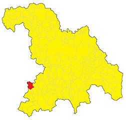
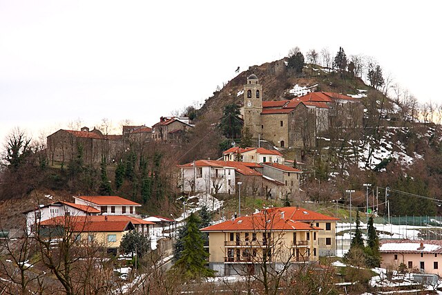
Ponti (Ponti)
- municipality in Italy
Hiking in Ponti, located in the Piedmont region of Italy, offers a blend of beautiful landscapes, rich history, and diverse trails suitable for various skill levels. Here are some key highlights about hiking in this area:
Natural Landscape
- Scenic Views: The landscape around Ponti is characterized by rolling hills, vineyards, and picturesque countryside typical of Piedmont. Hikers can enjoy stunning views, especially during sunrise and sunset.
- Forests and Trails: The region is home to picturesque forests, particularly oak and chestnut trees, providing shaded paths and a cool environment for hiking.
Trail Recommendations
- Local Trails: There are several local trails in and around Ponti that vary in difficulty. Some trails lead through vineyards, while others may take you to higher altitudes, offering panoramic views of the surrounding hills.
- Interconnected Routes: Many trails connect to broader hiking networks, allowing for longer hikes and diverse routes. You can easily plan a day hike or even multi-day excursions.
Tips for Hiking in Ponti
- Suitable Gear: Wear comfortable hiking shoes and appropriate clothing for the season. A good backpack with water, snacks, and a first aid kit is essential.
- Navigation: While many trails are marked, it’s advisable to carry a map or use a GPS device. Apps for hiking can also help track routes and provide additional information.
- Weather: Check the weather forecast before heading out, as conditions can change rapidly in the hills.
Local Culture
- Agrotourism: Many vineyards and farms in the area offer tours and tastings, which can be a wonderful way to relax after a hike. Enjoy local wines and traditional Piedmontese cuisine.
- Historic Sites: While hiking, you may encounter historical landmarks like ancient churches or castles, adding a cultural dimension to your outdoor experience.
Accessibility
- Transportation: Ponti is accessible by public transport and is a good starting point for exploring the surrounding areas. Consider visiting nearby towns, which might have additional hiking opportunities.
Conclusion
Hiking in Ponti, Piedmont, provides a wonderful opportunity to connect with nature while exploring the region's rich cultural heritage. Whether you're an experienced hiker or just starting out, there's something for everyone to enjoy in this beautiful area of Italy.
- Country:

- Postal Code: 15010
- Local Dialing Code: 0144
- Licence Plate Code: AL
- Coordinates: 44° 37' 44" N, 8° 21' 59" E


- GPS tracks (wikiloc): [Link]
- AboveSeaLevel: 186 м m
- Area: 11.97 sq km
- Population: 591
- Web site: https://www.comune.ponti.al.it
- Wikipedia en: wiki(en)
- Wikipedia: wiki(it)
- Wikidata storage: Wikidata: Q17642
- Wikipedia Commons Category: [Link]
- Freebase ID: [/m/0gbn8q]
- GeoNames ID: Alt: [6540314]
- OSM relation ID: [43395]
- ISTAT ID: 006134
- Italian cadastre code: G861
Shares border with regions:


Bistagno
- Comune of Italy
Bistagno is a charming village located in the Piedmont region of Italy, surrounded by beautiful landscapes that offer various hiking opportunities. While the area may not be as well-known as some larger hiking destinations, it provides a serene environment for outdoor enthusiasts, with trails that showcase the natural beauty of the region....
- Country:

- Postal Code: 15012
- Local Dialing Code: 0144
- Licence Plate Code: AL
- Coordinates: 44° 39' 40" N, 8° 22' 17" E


- GPS tracks (wikiloc): [Link]
- AboveSeaLevel: 175 м m
- Area: 17.59 sq km
- Population: 1813
- Web site: [Link]

Castelletto d'Erro
- municipality in Italy
Castelletto d'Erro is a small town in the Piedmont region of Italy, nestled in the scenic hills of the Monferrato area, making it a great destination for hiking enthusiasts. The landscape in this region is characterized by rolling hills, vineyards, and forests, offering a variety of trails suitable for different skill levels....
- Country:

- Postal Code: 15010
- Local Dialing Code: 0144
- Licence Plate Code: AL
- Coordinates: 44° 37' 38" N, 8° 23' 41" E


- GPS tracks (wikiloc): [Link]
- AboveSeaLevel: 544 м m
- Area: 4.66 sq km
- Population: 152
- Web site: [Link]
Denice
- municipality in Italy
It seems you might be referring to a specific location for hiking, but "Denice" is not a recognized hiking destination in major hiking directories or outdoor resources. It's possible you meant "Denali" in Alaska, which is a popular hiking and outdoor destination. If you meant a specific town or area named Denice, please provide me with more details so I can assist you better....
- Country:

- Postal Code: 15010
- Local Dialing Code: 0144
- Licence Plate Code: AL
- Coordinates: 44° 35' 59" N, 8° 20' 3" E


- GPS tracks (wikiloc): [Link]
- AboveSeaLevel: 387 м m
- Area: 7.46 sq km
- Population: 172
- Web site: [Link]

Montechiaro d'Acqui
- municipality in Italy
Montechiaro d'Acqui is a charming village located in the Piedmont region of Italy, particularly known for its beautiful landscapes and rich natural environment. While it may not be a major hiking destination, it offers various trails suitable for hiking enthusiasts looking to explore the lesser-known paths of the region....
- Country:

- Postal Code: 15010
- Local Dialing Code: 0144
- Licence Plate Code: AL
- Coordinates: 44° 35' 43" N, 8° 22' 47" E


- GPS tracks (wikiloc): [Link]
- AboveSeaLevel: 540 м m
- Area: 17.6 sq km
- Population: 540
- Web site: [Link]


Monastero Bormida
- Italian comune
Monastero Bormida is a charming village located in the Piedmont region of Italy, known for its picturesque landscapes, vineyards, and serene countryside. It is an excellent destination for hiking enthusiasts who wish to explore the beautiful terrain of the area....
- Country:

- Postal Code: 14058
- Local Dialing Code: 0144
- Licence Plate Code: AT
- Coordinates: 44° 38' 58" N, 8° 19' 40" E


- GPS tracks (wikiloc): [Link]
- AboveSeaLevel: 191 м m
- Area: 14.21 sq km
- Population: 934
- Web site: [Link]
Sessame
- Italian comune
It seems there might be a typo or misunderstanding regarding the name "Sessame." If you're referring to a specific hiking location, it could help to clarify the name or provide additional context....
- Country:

- Postal Code: 14050
- Local Dialing Code: 0144
- Licence Plate Code: AT
- Coordinates: 44° 40' 18" N, 8° 20' 16" E


- GPS tracks (wikiloc): [Link]
- AboveSeaLevel: 325 м m
- Area: 8.45 sq km
- Population: 264
- Web site: [Link]
