Pontvallain (Pontvallain)
- commune in Sarthe, France
- Country:

- Postal Code: 72510
- Coordinates: 47° 45' 1" N, 0° 11' 29" E


- GPS tracks (wikiloc): [Link]
- Area: 34.88 sq km
- Population: 1730
- Wikipedia en: wiki(en)
- Wikipedia: wiki(fr)
- Wikidata storage: Wikidata: Q769338
- Wikipedia Commons Category: [Link]
- Freebase ID: [/m/03qj0s9]
- GeoNames ID: Alt: [2986087]
- SIREN number: [217202431]
- BnF ID: [15273797h]
- INSEE municipality code: 72243
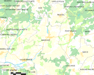
Shares border with regions:


Château-l'Hermitage
- commune in Sarthe, France
- Country:

- Postal Code: 72510
- Coordinates: 47° 48' 13" N, 0° 10' 54" E


- GPS tracks (wikiloc): [Link]
- Area: 9.39 sq km
- Population: 272


Mayet
- commune in Sarthe, France
- Country:

- Postal Code: 72360
- Coordinates: 47° 45' 32" N, 0° 16' 29" E


- GPS tracks (wikiloc): [Link]
- Area: 53.96 sq km
- Population: 3168
- Web site: [Link]


Saint-Biez-en-Belin
- commune in Sarthe, France
- Country:

- Postal Code: 72220
- Coordinates: 47° 49' 18" N, 0° 14' 19" E


- GPS tracks (wikiloc): [Link]
- Area: 9.27 sq km
- Population: 730
- Web site: [Link]


Écommoy
- commune in Sarthe, France
- Country:

- Postal Code: 72220
- Coordinates: 47° 49' 42" N, 0° 16' 23" E


- GPS tracks (wikiloc): [Link]
- Area: 28.5 sq km
- Population: 4642
- Web site: [Link]


Coulongé
- commune in Sarthe, France
- Country:

- Postal Code: 72800
- Coordinates: 47° 41' 22" N, 0° 12' 8" E


- GPS tracks (wikiloc): [Link]
- Area: 15.05 sq km
- Population: 536


Mansigné
- commune in Sarthe, France
- Country:

- Postal Code: 72510
- Coordinates: 47° 44' 50" N, 0° 8' 6" E


- GPS tracks (wikiloc): [Link]
- Area: 36.31 sq km
- Population: 1594
- Web site: [Link]


Requeil
- commune in Sarthe, France
- Country:

- Postal Code: 72510
- Coordinates: 47° 47' 4" N, 0° 9' 43" E


- GPS tracks (wikiloc): [Link]
- Area: 13.89 sq km
- Population: 1216
- Web site: [Link]


Sarcé
- commune in Sarthe, France
- Country:

- Postal Code: 72360
- Coordinates: 47° 43' 13" N, 0° 13' 14" E


- GPS tracks (wikiloc): [Link]
- Area: 10.99 sq km
- Population: 296
