
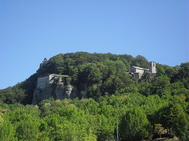
Poppi (Poppi)
.svg)
- Italian comune
 Hiking in Poppi
Poppi, located in the Tuscany region of Italy, offers wonderful hiking opportunities that allow you to explore both the natural beauty of the surrounding landscape and the rich history of the area. Here are some highlights for hiking in Poppi:
Scenic Trails
-
Casentino Forests: The nearby Casentino Forests, Monte Falterona, and Campigna National Park provide numerous trails that meander through lush forests, along rivers, and through breathtaking valleys. These trails cater to different skill levels, making it a great spot for both novice and experienced hikers.
-
Historical Trails: You can find trails that pass by historical landmarks, such as the Poppi Castle and ancient hermitages. This not only offers a physical challenge but also a chance to absorb the region's rich culture and history.
-
Nature and Wildlife: Look out for diverse flora and fauna, including deer, wild boars, and various bird species while hiking in the forests. The changing seasons add to the allure, with beautiful wildflowers in spring and vibrant autumn foliage.
Recommended Hikes
-
The Sentiero degli Dei (Path of the Gods): A panoramic route that offers stunning views of the Casentino Valley, ideal for those looking to experience the breathtaking scenery Tuscany is famous for.
-
E1 European Path: A part of the E1 trail runs through this region, connecting various points in Europe. Hiking this segment can give you a sense of the longer journey that many trekkers embark upon.
Preparation Tips
-
Weather Considerations: Check the local weather conditions before heading out, as they can change quickly, especially in higher elevations.
-
Trail Maps: It’s advisable to bring a detailed map or use a hiking app to navigate the trails, particularly if you are exploring less marked paths.
-
Proper Gear: Good hiking shoes, weather-appropriate clothing, and a backpack with sufficient water and snacks are essential for a comfortable hiking experience.
Local Regulations and Safety
Be sure to familiarize yourself with local regulations regarding hiking, such as any restrictions in natural reserves, and always practice Leave No Trace principles to preserve the natural beauty of the area.
Exploring the trails around Poppi is an excellent way to experience the spectacular landscapes of Tuscany while enjoying an active outdoor adventure!
- Country:

- Postal Code: 52014
- Local Dialing Code: 0575
- Licence Plate Code: AR
- Coordinates: 43° 44' 9" N, 11° 45' 42" E


- GPS tracks (wikiloc): [Link]
- AboveSeaLevel: 437 м m
- Area: 97.09 sq km
- Population: 6153
- Web site: http://www.comune.poppi.ar.it/
- Wikipedia en: wiki(en)
- Wikipedia: wiki(it)
- Wikidata storage: Wikidata: Q52095
- Wikipedia Commons Gallery: [Link]
- Wikipedia Commons Category: [Link]
- Freebase ID: [/m/0gm0fl]
- GeoNames ID: Alt: [6541883]
- VIAF ID: Alt: [154281216]
- OSM relation ID: [42565]
- GND ID: Alt: [4199590-9]
- archINFORM location ID: [1070]
- Quora topic ID: [Poppi]
- UN/LOCODE: [ITOIP]
- DMOZ ID: Alt: [Regional/Europe/Italy/Tuscany/Localities/Poppi/]
- ISTAT ID: 051031
- Italian cadastre code: G879
Shares border with regions:


Bibbiena
- Italian comune
Hiking in Bibbiena
Bibbiena, located in the Casentino area of Tuscany, Italy, is a fantastic destination for hiking enthusiasts. The region is characterized by its lush landscapes, rolling hills, and rich history. Here are some highlights to consider when hiking in and around Bibbiena:...
- Country:
- Postal Code: 52011
- Local Dialing Code: 0575
- Licence Plate Code: AR
- Coordinates: 43° 41' 51" N, 11° 48' 52" E
- GPS tracks (wikiloc): [Link]
- AboveSeaLevel: 425 м m
- Area: 87 sq km
- Population: 12177
- Web site: [Link]


Castel Focognano
- Italian comune
Hiking in Castel Focognano
Castel Focognano is a charming area located in the Tuscany region of Italy, known for its beautiful landscapes and hiking opportunities. Nestled in the Casentino Valley, this location is surrounded by nature, with trails that lead through picturesque forests, rolling hills, and offer stunning views of the surrounding countryside....
- Country:
- Postal Code: 52016
- Local Dialing Code: 0575
- Licence Plate Code: AR
- Coordinates: 43° 39' 12" N, 11° 47' 17" E
- GPS tracks (wikiloc): [Link]
- AboveSeaLevel: 310 м m
- Area: 56.63 sq km
- Population: 3093
- Web site: [Link]


Castel San Niccolò
- Italian comune
Hiking in Castel San Niccolò
Castel San Niccolò is a charming town located in the Casentino Valley in Tuscany, Italy. It's surrounded by picturesque landscapes and offers a variety of hiking opportunities, appealing to both seasoned hikers and casual walkers. Here are some key points to consider if you're planning a hike in the area:...
- Country:
- Postal Code: 52010; 52018
- Local Dialing Code: 0575
- Licence Plate Code: AR
- Coordinates: 43° 44' 43" N, 11° 42' 36" E
- GPS tracks (wikiloc): [Link]
- AboveSeaLevel: 380 м m
- Area: 83.27 sq km
- Population: 2667
- Web site: [Link]

Chiusi della Verna
- Italian comune
Hiking in Chiusi della Verna
Chiusi della Verna, nestled in the Casentino Forests of Tuscany, Italy, is a fantastic destination for hikers. It offers a blend of natural beauty, historical significance, and a variety of trails catering to different skill levels. Here are some key points to consider when hiking in Chiusi della Verna:...
- Country:
- Postal Code: 52010
- Local Dialing Code: 0575
- Licence Plate Code: AR
- Coordinates: 43° 41' 54" N, 11° 56' 10" E
- GPS tracks (wikiloc): [Link]
- AboveSeaLevel: 960 м m
- Area: 102.33 sq km
- Population: 2000
- Web site: [Link]


Ortignano Raggiolo
- Italian comune
Hiking in Ortignano Raggiolo
Ortignano Raggiolo is a charming village located in the Tuscany region of Italy, nestled in the Casentino Forests area. It offers a variety of hiking opportunities amid stunning landscapes characterized by picturesque hills, dense forests, and beautiful vistas. Here are some highlights and tips for hiking in and around Ortignano Raggiolo:...
- Country:
- Postal Code: 52010
- Local Dialing Code: 0575
- Licence Plate Code: AR
- Coordinates: 43° 40' 51" N, 11° 44' 59" E
- GPS tracks (wikiloc): [Link]
- AboveSeaLevel: 483 м m
- Area: 36.3 sq km
- Population: 881
- Web site: [Link]

Bagno di Romagna
- Italian comune
Hiking in Bagno di Romagna
Bagno di Romagna, located in the Emilia-Romagna region of Italy, is a beautiful destination for hiking enthusiasts. Nestled in the Casentino Forests, Monte Falterona, and Campigna National Park, this area offers a variety of trails that cater to different skill levels and interests, all within stunning natural surroundings....
- Country:
- Postal Code: 47021
- Local Dialing Code: 0543
- Licence Plate Code: FC
- Coordinates: 43° 50' 0" N, 11° 58' 0" E
- GPS tracks (wikiloc): [Link]
- AboveSeaLevel: 491 м m
- Area: 233.52 sq km
- Population: 5874
- Web site: [Link]