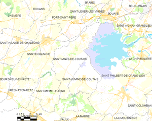
Port-Saint-Père (Port-Saint-Père)

- commune in Loire-Atlantique, France
- Country:

- Postal Code: 44710
- Coordinates: 47° 7' 59" N, 1° 44' 54" E


- GPS tracks (wikiloc): [Link]
- Area: 32.57 sq km
- Population: 2894
- Web site: http://www.mairie-port-saint-pere.fr
- Wikipedia en: wiki(en)
- Wikipedia: wiki(fr)
- Wikidata storage: Wikidata: Q650520
- Wikipedia Commons Category: [Link]
- Freebase ID: [/m/03nwctf]
- Freebase ID: [/m/03nwctf]
- GeoNames ID: Alt: [2985932]
- GeoNames ID: Alt: [2985932]
- SIREN number: [214401333]
- SIREN number: [214401333]
- BnF ID: [15260302z]
- BnF ID: [15260302z]
- VIAF ID: Alt: [236126279]
- VIAF ID: Alt: [236126279]
- GND ID: Alt: [4673127-1]
- GND ID: Alt: [4673127-1]
- PACTOLS thesaurus ID: [pcrtBblfdohmbc]
- PACTOLS thesaurus ID: [pcrtBblfdohmbc]
- Songkick venue ID: [2629743]
- Songkick venue ID: [2629743]
- INSEE municipality code: 44133
- INSEE municipality code: 44133
Shares border with regions:

Saint-Mars-de-Coutais
- commune in Loire-Atlantique, France
- Country:
- Postal Code: 44680
- Coordinates: 47° 6' 42" N, 1° 44' 4" E
- GPS tracks (wikiloc): [Link]
- Area: 34.67 sq km
- Population: 2627
- Web site: [Link]


Saint-Hilaire-de-Chaléons
- commune in Loire-Atlantique, France
- Country:
- Postal Code: 44680
- Coordinates: 47° 6' 11" N, 1° 51' 54" E
- GPS tracks (wikiloc): [Link]
- Area: 34.98 sq km
- Population: 2235
- Web site: [Link]


Sainte-Pazanne
- commune in Loire-Atlantique, France
- Country:
- Postal Code: 44680
- Coordinates: 47° 6' 11" N, 1° 48' 39" E
- GPS tracks (wikiloc): [Link]
- Area: 41.56 sq km
- Population: 6547
- Web site: [Link]


Cheix-en-Retz
- commune in Loire-Atlantique, France
- Country:
- Postal Code: 44640
- Coordinates: 47° 10' 54" N, 1° 48' 56" E
- GPS tracks (wikiloc): [Link]
- Area: 8.34 sq km
- Population: 1027
- Web site: [Link]


Rouans
- commune in Loire-Atlantique, France
- Country:
- Postal Code: 44640
- Coordinates: 47° 11' 7" N, 1° 51' 35" E
- GPS tracks (wikiloc): [Link]
- Area: 37.73 sq km
- Population: 2860
- Web site: [Link]


Saint-Léger-les-Vignes
- commune in Loire-Atlantique, France
- Country:
- Postal Code: 44710
- Coordinates: 47° 8' 10" N, 1° 43' 56" E
- GPS tracks (wikiloc): [Link]
- Area: 6.49 sq km
- Population: 1708
- Web site: [Link]


Brains
- commune in Loire-Atlantique, France
- Country:
- Postal Code: 44830
- Coordinates: 47° 10' 9" N, 1° 43' 18" E
- GPS tracks (wikiloc): [Link]
- Area: 15.31 sq km
- Population: 2741
- Web site: [Link]