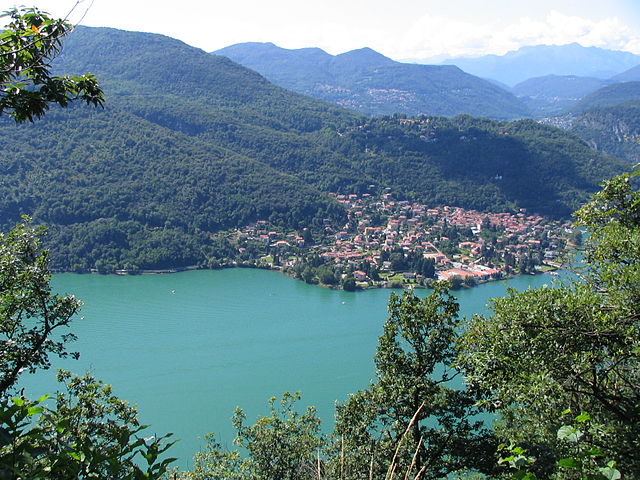
Porto Ceresio (Porto Ceresio)
.svg)
- Italian comune
 Hiking in Porto Ceresio
Porto Ceresio is a charming town located on the shores of Lake Lugano in Italy, near the Swiss border. It is surrounded by beautiful landscapes and offers various hiking opportunities for outdoor enthusiasts. Here are some highlights of hiking in and around Porto Ceresio:
-
Scenic Trails: The area features a mix of wooded paths, lakeside promenades, and mountain trails. The views over Lake Lugano and the surrounding hills are breathtaking and make for excellent photography opportunities.
-
Monte S. Giorgio: A UNESCO World Heritage site, this mountain offers several hiking routes. The trails vary in difficulty and provide stunning views of Lake Lugano and the surrounding area, making it a popular spot for more experienced hikers as well.
-
Sentiero del Viandante: This is a well-marked hiking trail that runs along the eastern shore of Lake Lugano and offers a beautiful way to experience the region's natural beauty and quaint villages.
-
Wildlife and Flora: The area around Porto Ceresio is rich in biodiversity. Hikers may encounter diverse plant species and local wildlife, making the hikes not only scenic but also an opportunity for nature enthusiasts to observe and enjoy natural habitats.
-
Preparation: As with any hiking trip, it's important to prepare adequately. Bring enough water, snacks, and wear appropriate footwear. Weather can change quickly, so check forecasts and consider layering your clothing.
-
Local Guides: If you're new to the area or looking for a more structured experience, consider hiring a local hiking guide. They can provide insights into the region's history, ecology, and hidden gems.
-
Accessibility: Many of the trails are accessible and suitable for different skill levels. However, some may be steep or rugged, so it's advisable to choose paths that match your fitness level.
-
Cultural Experience: Porto Ceresio has a rich cultural backdrop, so take time to explore local architecture, cuisine, and hospitality after your hike.
In summary, Porto Ceresio offers a diverse hiking experience with stunning views, varied trails, and a chance to enjoy local culture. Whether you’re a beginner or an experienced hiker, this area has something to offer for everyone.
- Country:

- Postal Code: 21050
- Local Dialing Code: 0332
- Licence Plate Code: VA
- Coordinates: 45° 54' 0" N, 8° 54' 0" E


- GPS tracks (wikiloc): [Link]
- AboveSeaLevel: 280 м m
- Area: 5.34 sq km
- Population: 2940
- Web site: http://www.comune.portoceresio.va.it
- Wikipedia en: wiki(en)
- Wikipedia: wiki(it)
- Wikidata storage: Wikidata: Q39216
- Wikipedia Commons Gallery: [Link]
- Wikipedia Commons Category: [Link]
- Freebase ID: [/m/0ghzpj]
- GeoNames ID: Alt: [6540572]
- VIAF ID: Alt: [134768434]
- OSM relation ID: [46462]
- ISTAT ID: 012113
- Italian cadastre code: G906
Shares border with regions:

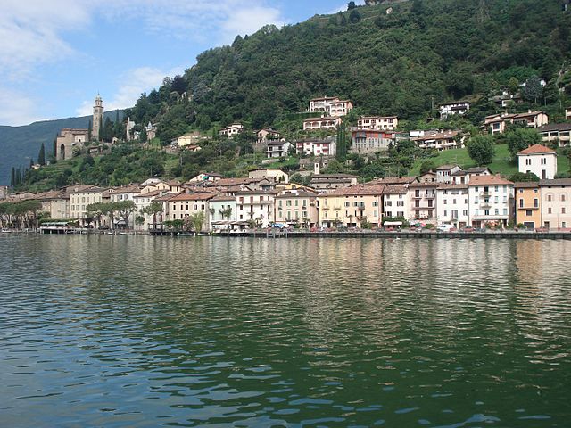
Brusimpiano
- Italian comune
Hiking in Brusimpiano
Brusimpiano is a charming village located in the province of Varese, Lombardy, Italy, and is situated near the beautiful Lake Lugano. The surrounding area offers lovely hiking opportunities, blending stunning natural scenery with views of the lake and the nearby mountains....
- Country:
- Postal Code: 21050
- Local Dialing Code: 0332
- Licence Plate Code: VA
- Coordinates: 45° 57' 0" N, 8° 53' 0" E
- GPS tracks (wikiloc): [Link]
- AboveSeaLevel: 289 м m
- Area: 5.91 sq km
- Population: 1213
- Web site: [Link]
Cuasso al Monte
- Italian comune
Hiking in Cuasso al Monte
Cuasso al Monte is a charming municipality located in the province of Varese, in the Lombardy region of northern Italy. It's nestled in the foothills of the Prealps and offers a variety of hiking opportunities that cater to different skill levels, with stunning views of the surrounding mountains and nearby Lake Lugano....
- Country:
- Postal Code: 21050
- Local Dialing Code: 0332
- Licence Plate Code: VA
- Coordinates: 45° 52' 0" N, 8° 52' 0" E
- GPS tracks (wikiloc): [Link]
- AboveSeaLevel: 537 м m
- Area: 16.18 sq km
- Population: 3613
- Web site: [Link]
Besano
- Italian comune
Hiking in Besano
Besano, located in the Lombardy region of Italy near the Swiss border, is known for its beautiful natural landscapes and hiking opportunities. This area offers a variety of trails suitable for different skill levels, ranging from easy walks to more challenging treks. Here are some highlights of hiking in Besano:...
- Country:
- Postal Code: 21050
- Local Dialing Code: 0332
- Licence Plate Code: VA
- Coordinates: 45° 53' 0" N, 8° 53' 0" E
- GPS tracks (wikiloc): [Link]
- AboveSeaLevel: 537 м m
- Area: 3.43 sq km
- Population: 2583
- Web site: [Link]

Morcote
- municipality in the canton of Ticino, Switzerland
Hiking in Morcote
Morcote, a picturesque village located on the shores of Lake Lugano in the canton of Ticino, Switzerland, offers stunning landscapes and various hiking opportunities that allow you to explore its natural beauty and cultural heritage....
- Country:

- Postal Code: 6922
- Local Dialing Code: 091
- Licence Plate Code: TI
- Coordinates: 45° 55' 30" N, 8° 54' 58" E
- GPS tracks (wikiloc): [Link]
- AboveSeaLevel: 632 м m
- Area: 2.8 sq km
- Population: 725
- Web site: [Link]

Mendrisio
- town in the canton of Ticino, Switzerland
Hiking in Mendrisio
Mendrisio, located in the Italian-speaking region of Switzerland, is a fantastic destination for hiking enthusiasts. The area is characterized by its stunning landscapes, charming villages, and impressive views of the surrounding hills and mountains. Here are some key points to consider when hiking in and around Mendrisio:...
- Country:
- Postal Code: 6850
- Local Dialing Code: 091
- Licence Plate Code: TI
- Coordinates: 45° 52' 0" N, 8° 59' 0" E
- GPS tracks (wikiloc): [Link]
- AboveSeaLevel: 354 м m
- Area: 32.01 sq km
- Population: 14914
- Web site: [Link]
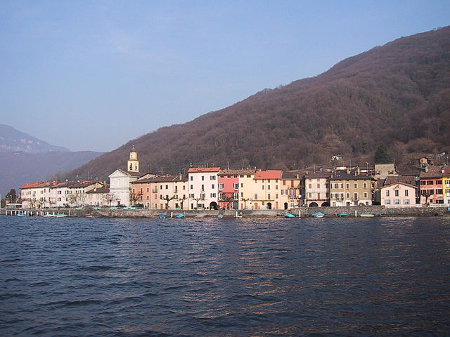

Brusino Arsizio
- municipality in the canton of Ticino, Switzerland
Hiking in Brusino Arsizio
Brusino Arsizio is a picturesque village located in the Swiss region of Ticino, near the shores of Lake Lugano. It's an excellent destination for hiking enthusiasts, offering a variety of trails that cater to different skill levels. Here are some highlights of hiking in this area:...
- Country:
- Postal Code: 6827
- Local Dialing Code: 091
- Licence Plate Code: TI
- Coordinates: 45° 55' 42" N, 8° 56' 19" E
- GPS tracks (wikiloc): [Link]
- AboveSeaLevel: 551 м m
- Area: 5.78 sq km
- Population: 485
- Web site: [Link]