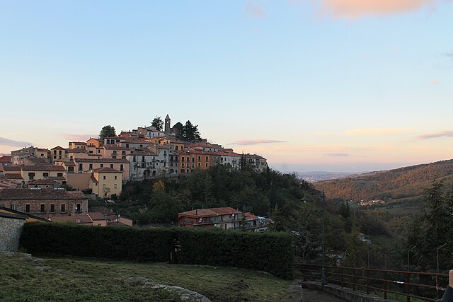
Potenza (Potenza)
.svg)
- Italian comune
 Hiking in Potenza
Potenza, the capital of the Basilicata region in southern Italy, offers a variety of hiking opportunities that allow you to explore its stunning natural landscapes and historical sites. Here are some key points to consider when hiking in and around Potenza:
Natural Attractions
-
Parco Nazionale Appennino Lucano Val d'Agri Lagonegrese: This national park offers numerous trails through unspoiled nature, featuring rugged mountains, lush forests, and rivers. The trails vary in difficulty, making it suitable for both beginners and experienced hikers. The park is also home to diverse wildlife and unique flora.
-
Monti Potenti: This mountain range near Potenza offers scenic views and a plethora of hiking trails. The area is great for day hikes, providing trails that can take you to panoramic viewpoints of the surrounding countryside.
-
Val d'Agri: This valley is known for its beautiful landscapes and is a great area for hiking. The region has several well-marked trails that can lead you to picturesque spots for photography and outdoor activities.
Historical Trails
Potenza has historical significance, and some trails combine hiking with visits to ancient ruins and medieval villages. Consider hiking routes that pass through towns like:
- Pietragalla: Known for its charming old town, it's a nice stop on a hike.
- Cancellara: A small village with historical buildings worth visiting.
General Tips
- Trail Markings: Most trails are well-marked, but it’s always good to have a map or GPS device with you, especially when exploring lesser-known paths.
- Weather Considerations: The climate can change quickly in the mountains, so check the weather forecast and be prepared with appropriate clothing and gear.
- Local Guides: If you’re new to the area or hiking, consider hiring a local guide who can enhance your experience with knowledge about the terrain, flora, and fauna.
- Accommodations: Look for local agriturismos or bed-and-breakfasts in Potenza for a local experience and to support the community.
Summary
Hiking in Potenza is a delightful way to experience the natural beauty and cultural heritage of Basilicata. Whether you’re trekking through national parks or exploring historical towns, you’ll find a range of options tailored to different levels of hikers. Don’t forget to savor local cuisine and wines after your adventures!
- Country:

- Postal Code: 85100
- Local Dialing Code: 0971
- Licence Plate Code: PZ
- Coordinates: 40° 38' 0" N, 15° 48' 0" E


- GPS tracks (wikiloc): [Link]
- AboveSeaLevel: 819 м m
- Area: 175.43 sq km
- Population: 67211
- Web site: http://www.comune.potenza.it/
- Wikipedia en: wiki(en)
- Wikipedia: wiki(it)
- Wikidata storage: Wikidata: Q3543
- Wikipedia Commons Gallery: [Link]
- Wikipedia Commons Category: [Link]
- Freebase ID: [/m/0cfcgz]
- GeoNames ID: Alt: [6541470]
- BnF ID: [122454912]
- VIAF ID: Alt: [3161153532461048820007]
- OSM relation ID: [40613]
- GND ID: Alt: [4243969-3]
- archINFORM location ID: [4843]
- PACTOLS thesaurus ID: [pcrtke1pXaNEbq]
- MusicBrainz area ID: [4b7fdc39-918d-4a58-8839-721a1dbea876]
- Quora topic ID: [Potenza-Italy]
- UN/LOCODE: [ITQPO]
- Encyclopædia Britannica Online ID: [place/Potenza-Italy]
- Facebook Places ID: [106275046077052]
- Digital Atlas of the Roman Empire ID: [42258]
- ISTAT ID: 076063
- Italian cadastre code: G942
Shares border with regions:


Anzi, Italy
- Italian comune
Hiking in Anzi, Italy
Anzi is a charming village located in the Basilicata region of southern Italy, nestled in the heart of the Apennine mountains. The area surrounding Anzi offers a variety of hiking opportunities that showcase the stunning landscapes, rich biodiversity, and cultural heritage of Basilicata....
- Country:
- Postal Code: 85010
- Local Dialing Code: 0971
- Licence Plate Code: PZ
- Coordinates: 40° 31' 0" N, 15° 55' 0" E
- GPS tracks (wikiloc): [Link]
- AboveSeaLevel: 1067 м m
- Area: 77.1 sq km
- Population: 1648
- Web site: [Link]


Avigliano
- town and comune in the Italian region of Basilicata
Hiking in Avigliano
Avigliano is a charming town located in southern Italy, surrounded by beautiful natural landscapes, making it a great location for hiking enthusiasts. The area features rolling hills, forests, and scenic views that cater to various skill levels. Here are some highlights about hiking in and around Avigliano:...
- Country:
- Postal Code: 85021
- Local Dialing Code: 0971
- Licence Plate Code: PZ
- Coordinates: 40° 44' 0" N, 15° 43' 0" E
- GPS tracks (wikiloc): [Link]
- AboveSeaLevel: 827 м m
- Area: 85.48 sq km
- Population: 11350
- Web site: [Link]
Brindisi Montagna
- Italian comune
Hiking in Brindisi Montagna
Brindisi Montagna, located in the Basilicata region of southern Italy, is a great destination for hiking enthusiasts, thanks to its stunning natural landscapes, rich biodiversity, and historical significance. Here’s what you need to know about hiking in this beautiful area:...
- Country:
- Postal Code: 85010
- Local Dialing Code: 0971
- Licence Plate Code: PZ
- Coordinates: 40° 37' 0" N, 15° 56' 0" E
- GPS tracks (wikiloc): [Link]
- AboveSeaLevel: 800 м m
- Area: 59.88 sq km
- Population: 881
- Web site: [Link]
Picerno
- Italian comune
Hiking in Picerno
Picerno, a charming town located in the Basilicata region of southern Italy, offers a variety of hiking opportunities that allow you to explore its beautiful landscapes, rich flora and fauna, and historical sites. Here are some key points about hiking in and around Picerno:...
- Country:
- Postal Code: 85055
- Local Dialing Code: 0971
- Licence Plate Code: PZ
- Coordinates: 40° 38' 0" N, 15° 38' 0" E
- GPS tracks (wikiloc): [Link]
- AboveSeaLevel: 721 м m
- Area: 78.51 sq km
- Population: 5869
- Web site: [Link]


Pietragalla
- Italian comune
Hiking in Pietragalla
Pietragalla is a charming town located in the Basilicata region of southern Italy. It offers a great backdrop for hiking enthusiasts, thanks to its scenic landscapes and surrounding natural beauty....
- Country:
- Postal Code: 85016
- Local Dialing Code: 0971
- Licence Plate Code: PZ
- Coordinates: 40° 45' 0" N, 15° 53' 0" E
- GPS tracks (wikiloc): [Link]
- AboveSeaLevel: 839 м m
- Area: 66.1 sq km
- Population: 4064
- Web site: [Link]
Pignola
- Italian comune
Hiking in Pignola
Pignola, located in the Basilicata region of southern Italy, offers a range of hiking opportunities amidst its stunning landscapes, rich biodiversity, and charming rural scenery. Here are some key points to consider when hiking in and around Pignola:...
- Country:
- Postal Code: 85010
- Local Dialing Code: 0971
- Licence Plate Code: PZ
- Coordinates: 40° 34' 0" N, 15° 47' 0" E
- GPS tracks (wikiloc): [Link]
- AboveSeaLevel: 926 м m
- Area: 56.24 sq km
- Population: 6908
- Web site: [Link]
Ruoti
- Italian comune
Hiking in Ruoti
Ruoti is a charming village in the province of Potenza, located in the Basilicata region of southern Italy. It is known for its picturesque landscapes, lush greenery, and rich cultural heritage, making it an excellent destination for hiking enthusiasts. Here are some key points about hiking in and around Ruoti:...
- Country:
- Postal Code: 85056
- Local Dialing Code: 0971
- Licence Plate Code: PZ
- Coordinates: 40° 43' 0" N, 15° 41' 0" E
- GPS tracks (wikiloc): [Link]
- AboveSeaLevel: 756 м m
- Area: 55.45 sq km
- Population: 3542
- Web site: [Link]


Tito
- Italian comune
Hiking in Tito
Hiking in Tito, a town situated in the Basilicata region of Italy, offers a wonderful blend of natural beauty, historical sites, and diverse landscapes. Here are some key points to consider:...
- Country:
- Postal Code: 85050
- Local Dialing Code: 0971
- Licence Plate Code: PZ
- Coordinates: 40° 35' 0" N, 15° 41' 0" E
- GPS tracks (wikiloc): [Link]
- AboveSeaLevel: 650 м m
- Area: 71.27 sq km
- Population: 7355
- Web site: [Link]


Vaglio Basilicata
- Italian comune
Hiking in Vaglio Basilicata
Vaglio Basilicata, located in the Basilicata region of southern Italy, is a fantastic destination for hiking enthusiasts. Nestled in the Basento Valley, the area is characterized by its stunning natural landscapes, rich history, and charming rural setting. Here are some highlights and suggestions for hiking in Vaglio Basilicata:...
- Country:
- Postal Code: 85010
- Local Dialing Code: 0971
- Licence Plate Code: PZ
- Coordinates: 40° 40' 31" N, 15° 53' 46" E
- GPS tracks (wikiloc): [Link]
- AboveSeaLevel: 954 м m
- Area: 43.36 sq km
- Population: 1994
- Web site: [Link]