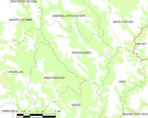
Prendeignes (Prendeignes)
- commune in Lot, France
- Country:

- Postal Code: 46270
- Coordinates: 44° 41' 51" N, 2° 5' 21" E


- GPS tracks (wikiloc): [Link]
- Area: 15.76 sq km
- Population: 227
- Web site: http://www.prendeignes.fr
- Wikipedia en: wiki(en)
- Wikipedia: wiki(fr)
- Wikidata storage: Wikidata: Q1321548
- Wikipedia Commons Category: [Link]
- Freebase ID: [/m/03nwnw6]
- GeoNames ID: Alt: [6434860]
- SIREN number: [214602260]
- BnF ID: [152609676]
- INSEE municipality code: 46226
Shares border with regions:
Saint-Cirgues
- commune in Lot, France
- Country:

- Postal Code: 46210
- Coordinates: 44° 44' 15" N, 2° 7' 27" E


- GPS tracks (wikiloc): [Link]
- Area: 32.5 sq km
- Population: 352
- Web site: [Link]
Sainte-Colombe
- commune in Lot, France
- Country:

- Postal Code: 46120
- Coordinates: 44° 43' 24" N, 2° 0' 9" E


- GPS tracks (wikiloc): [Link]
- Area: 11.35 sq km
- Population: 202
Sabadel-Latronquière
- commune in Lot, France
- Country:

- Postal Code: 46210
- Coordinates: 44° 44' 8" N, 2° 3' 38" E


- GPS tracks (wikiloc): [Link]
- Area: 12.29 sq km
- Population: 95


Linac
- commune in Lot, France
- Country:

- Postal Code: 46270
- Coordinates: 44° 39' 56" N, 2° 6' 52" E


- GPS tracks (wikiloc): [Link]
- Area: 12.3 sq km
- Population: 218


Saint-Perdoux
- commune in Lot, France
- Country:

- Postal Code: 46100
- Coordinates: 44° 40' 24" N, 2° 2' 51" E


- GPS tracks (wikiloc): [Link]
- Area: 12.53 sq km
- Population: 199
Viazac
- commune in Lot, France
- Country:

- Postal Code: 46100
- Coordinates: 44° 38' 28" N, 2° 4' 30" E


- GPS tracks (wikiloc): [Link]
- Area: 17.74 sq km
- Population: 324


Cardaillac
- commune in Lot, France
- Country:

- Postal Code: 46100
- Coordinates: 44° 40' 48" N, 1° 59' 49" E


- GPS tracks (wikiloc): [Link]
- Area: 18.1 sq km
- Population: 602
- Web site: [Link]
