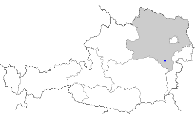
Prigglitz (Prigglitz)
- municipality in Austria
Prigglitz is a scenic village located in Lower Austria, surrounded by the beautiful landscapes of the Wienerwald (Vienna Woods). The region offers a variety of hiking opportunities, ranging from leisurely walks to more challenging hikes, making it suitable for all levels of hikers.
Hiking Trails
-
Wanderwege (Walking Paths): The area is crisscrossed with numerous marked walking paths. Look for local hiking maps or apps that provide details on trail lengths and difficulties.
-
Nature Trails: Many of the trails in the region focus on the natural beauty, showcasing local flora and fauna. Some paths are equipped with information boards about the local ecosystem.
-
Panoramic Routes: Some trails offer stunning views of the surrounding countryside and forests, making for great photo opportunities. The higher trails can provide stunning panoramas of the Vienna Woods.
Difficulty Levels
- Easy Trails: Suitable for families and beginners, with gentle slopes and well-marked paths.
- Moderate Trails: These may have some inclines and rocky sections but are still accessible to most hikers with a reasonable fitness level.
- Challenging Trails: For experienced hikers seeking more strenuous climbs and rugged terrain.
Best Time to Hike
- Spring and Fall: These seasons offer mild weather and beautiful scenery as the flora blooms or the leaves change color. Late spring may also reward you with blooming wildflowers.
- Summer: Ideal for longer hikes, but be mindful of heat and stay hydrated.
- Winter: Certain trails can be hiked in winter, but it's essential to check the conditions, as snow and ice may affect safety.
Safety Tips
- Always check the weather forecast before heading out.
- Wear appropriate footwear and clothing.
- Carry plenty of water, snacks, and a map of the area.
- Ensure you have a fully charged mobile phone for emergencies.
- Let someone know your hiking plans.
Local Amenities
After a day of hiking, you may find taverns and restaurants in Prigglitz where you can enjoy local Austrian cuisine. It's a good idea to experience regional dishes and perhaps sample some local wines.
Conclusion
Hiking in Prigglitz offers a fantastic way to connect with nature and explore the stunning scenery of Lower Austria. Whether you're a beginner or an experienced hiker, there are trails to suit everyone. Always prioritize safety and enjoy the beauty of the great outdoors!
- Country:

- Postal Code: 2630, 2640
- Local Dialing Code: 02662
- Licence Plate Code: NK
- Coordinates: 47° 42' 9" N, 15° 55' 41" E


- GPS tracks (wikiloc): [Link]
- AboveSeaLevel: 635 м m
- Area: 17.97 sq km
- Population: 434
- Web site: http://www.prigglitz.at/
- Wikipedia en: wiki(en)
- Wikipedia: wiki(de)
- Wikidata storage: Wikidata: Q592775
- Wikipedia Commons Category: [Link]
- Freebase ID: [/m/02qzlqg]
- GeoNames ID: Alt: [7871868]
- VIAF ID: Alt: [240528312]
- Austrian municipality key: [31825]
Shares border with regions:


Ternitz
- municipality in Austria
Ternitz, located in Lower Austria, offers a variety of hiking opportunities that cater to different skill levels. The region is characterized by its beautiful landscapes, rolling hills, and lush forests, providing a scenic backdrop for outdoor enthusiasts....
- Country:

- Postal Code: 2620, 2630, 2631, 2632, 2732, 2733, 2734
- Local Dialing Code: 02630
- Licence Plate Code: NK
- Coordinates: 47° 43' 0" N, 16° 2' 0" E


- GPS tracks (wikiloc): [Link]
- AboveSeaLevel: 393 м m
- Area: 65.35 sq km
- Population: 14632
- Web site: [Link]
Bürg-Vöstenhof
- municipality in Austria
Bürg-Vöstenhof is a charming area located in Germany, well-known for its picturesque landscapes and outdoor recreation opportunities, including hiking. The region typically features a variety of marked trails that cater to different skill levels, making it accessible for both novice hikers and seasoned trekkers....
- Country:

- Postal Code: 2630
- Local Dialing Code: 02630
- Licence Plate Code: NK
- Coordinates: 47° 43' 0" N, 15° 58' 0" E


- GPS tracks (wikiloc): [Link]
- AboveSeaLevel: 570 м m
- Area: 25.12 sq km
- Population: 179
- Web site: [Link]


Payerbach
- municipality in Austria
Payerbach is a picturesque village located in the Lower Austria region, nestled at the foot of the Rax mountains. It serves as a great starting point for various hiking trails that cater to different levels of experience and fitness. Here are some key highlights of hiking in and around Payerbach:...
- Country:

- Local Dialing Code: 02666
- Licence Plate Code: NK
- Coordinates: 47° 40' 0" N, 15° 50' 0" E


- GPS tracks (wikiloc): [Link]
- AboveSeaLevel: 483 м m
- Area: 17.66 sq km
- Population: 2076
- Web site: [Link]

Gloggnitz
- municipality in Austria
Gloggnitz is a charming town located in Austria's Lower Austria region, surrounded by picturesque landscapes and a variety of hiking opportunities. Here are some key points to consider if you're planning a hiking trip to Gloggnitz:...
- Country:

- Local Dialing Code: 02662
- Licence Plate Code: NK
- Coordinates: 47° 40' 33" N, 15° 56' 18" E


- GPS tracks (wikiloc): [Link]
- AboveSeaLevel: 442 м m
- Area: 19.55 sq km
- Population: 5916
- Web site: [Link]
Buchbach
- municipality in Austria
Buchbach, located in Austria, is an excellent destination for hiking enthusiasts, offering a variety of trails that cater to different skill levels. Nestled in a picturesque landscape of rolling hills, lush forests, and scenic mountain views, it provides both beginners and experienced hikers with ample opportunities to explore the natural beauty of the region....
- Country:

- Local Dialing Code: 02630
- Licence Plate Code: NK
- Coordinates: 47° 41' 48" N, 15° 59' 3" E


- GPS tracks (wikiloc): [Link]
- AboveSeaLevel: 485 м m
- Area: 2.99 sq km
- Population: 330
- Web site: [Link]
