Quincy (Quincy)

- commune in Cher, France
- Country:

- Postal Code: 18120
- Coordinates: 47° 8' 1" N, 2° 9' 25" E


- GPS tracks (wikiloc): [Link]
- Area: 18.19 sq km
- Population: 884
- Wikipedia en: wiki(en)
- Wikipedia: wiki(fr)
- Wikidata storage: Wikidata: Q829696
- Wikipedia Commons Category: [Link]
- Freebase ID: [/m/03md2mx]
- GeoNames ID: Alt: [6428255]
- SIREN number: [211801907]
- BnF ID: [15249536k]
- INSEE municipality code: 18190
Shares border with regions:


Cerbois
- commune in Cher, France
- Country:
- Postal Code: 18120
- Coordinates: 47° 6' 22" N, 2° 6' 9" E
- GPS tracks (wikiloc): [Link]
- Area: 18.45 sq km
- Population: 432
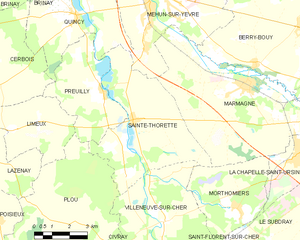
Sainte-Thorette
- commune in Cher, France
- Country:
- Postal Code: 18500
- Coordinates: 47° 4' 53" N, 2° 11' 56" E
- GPS tracks (wikiloc): [Link]
- Area: 26.54 sq km
- Population: 474


Brinay
- commune in Cher, France
- Country:
- Postal Code: 18120
- Coordinates: 47° 10' 39" N, 2° 7' 40" E
- GPS tracks (wikiloc): [Link]
- Area: 29.48 sq km
- Population: 530


Foëcy
- commune in Cher, France
- Country:
- Postal Code: 18500
- Coordinates: 47° 10' 37" N, 2° 9' 42" E
- GPS tracks (wikiloc): [Link]
- Area: 16.21 sq km
- Population: 2079

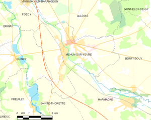
Mehun-sur-Yèvre
- commune in Cher, France
- Country:
- Postal Code: 18500
- Coordinates: 47° 8' 43" N, 2° 12' 57" E
- GPS tracks (wikiloc): [Link]
- Area: 24.45 sq km
- Population: 6644
- Web site: [Link]


Preuilly
- commune in Cher, France
- Country:
- Postal Code: 18120
- Coordinates: 47° 5' 42" N, 2° 10' 36" E
- GPS tracks (wikiloc): [Link]
- Area: 14.94 sq km
- Population: 446