Réjaumont (Réjaumont)

- commune in Hautes-Pyrénées, France
- Country:

- Postal Code: 65300
- Coordinates: 43° 9' 34" N, 0° 26' 59" E


- GPS tracks (wikiloc): [Link]
- Area: 6.7 sq km
- Population: 168
- Wikipedia en: wiki(en)
- Wikipedia: wiki(fr)
- Wikidata storage: Wikidata: Q1410556
- Wikipedia Commons Category: [Link]
- Freebase ID: [/m/03w9mhj]
- Freebase ID: [/m/03w9mhj]
- GeoNames ID: Alt: [6613841]
- GeoNames ID: Alt: [6613841]
- SIREN number: [216503771]
- SIREN number: [216503771]
- BnF ID: [15270808m]
- BnF ID: [15270808m]
- INSEE municipality code: 65377
- INSEE municipality code: 65377
Shares border with regions:


Clarens
- commune in Hautes-Pyrénées, France
- Country:
- Postal Code: 65300
- Coordinates: 43° 9' 46" N, 0° 24' 52" E
- GPS tracks (wikiloc): [Link]
- Area: 11.3 sq km
- Population: 526
Uglas
- commune in Hautes-Pyrénées, France
- Country:
- Postal Code: 65300
- Coordinates: 43° 8' 28" N, 0° 26' 1" E
- GPS tracks (wikiloc): [Link]
- Area: 8.54 sq km
- Population: 288
Monlong
- commune in Hautes-Pyrénées, France
- Country:
- Postal Code: 65670
- Coordinates: 43° 12' 22" N, 0° 27' 51" E
- GPS tracks (wikiloc): [Link]
- Area: 7.21 sq km
- Population: 107

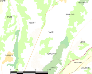
Tajan
- commune in Hautes-Pyrénées, France
- Country:
- Postal Code: 65300
- Coordinates: 43° 11' 18" N, 0° 27' 36" E
- GPS tracks (wikiloc): [Link]
- Area: 4.93 sq km
- Population: 142
Arné
- commune in Hautes-Pyrénées, France
- Country:
- Postal Code: 65670
- Coordinates: 43° 11' 9" N, 0° 30' 19" E
- GPS tracks (wikiloc): [Link]
- Area: 8.34 sq km
- Population: 214