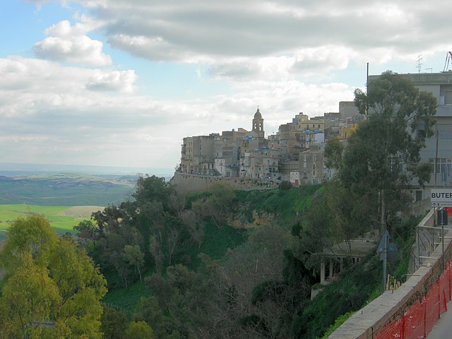
Ravanusa (Ravanusa)
.svg)
- Italian comune
 Hiking in Ravanusa
Ravanusa, a small town in Sicily, Italy, is not widely recognized as a traditional hiking destination. However, the surrounding region offers beautiful landscapes and opportunities for hiking enthusiasts. Here are some things to consider when hiking around Ravanusa:
-
Natural Terrain: The area around Ravanusa features hilly terrain and scenic views typical of Sicily. You'll find rolling hills, vineyards, and possibly some remote areas that showcase the island's natural beauty.
-
Nearby Parks: While Ravanusa itself may not have dedicated hiking trails, it is located relatively close to several natural parks and reserves. For example, you can explore the nearby Gangi Natural Reserve or the Etna Regional Park (though a bit further away) if you’re willing to drive. These parks offer a range of trails from gentle walks to more strenuous hikes.
-
Culture and Heritage: Hiking in this area also allows you to combine outdoor activities with cultural experiences. You can explore ancient ruins, churches, and local vineyards. Consider planning hikes that lead to small villages or historical sites.
-
Climate Considerations: Sicily generally enjoys a Mediterranean climate, which means warm, dry summers and mild winters. Early spring and late fall are ideal times for hiking, as temperatures are more moderate and the scenery is often lush and vibrant.
-
Safety and Preparation: Always ensure you are well-prepared. Bring adequate water, wear appropriate footwear, and take a map or GPS device, especially if you are venturing into less well-marked trails.
-
Local regulations: Be aware of any regulations regarding access to certain areas, especially if hiking in a protected area. It’s also respectful to be mindful of the local wildlife and plant life.
In conclusion, while Ravanusa itself may not be famous for hiking, the surrounding areas provide ample opportunities for outdoor exploration. Combining your hiking pursuits with cultural exploration will enhance your experience in this beautiful part of Sicily.
- Country:

- Postal Code: 92029
- Local Dialing Code: 0922
- Licence Plate Code: AG
- Coordinates: 37° 16' 4" N, 13° 58' 11" E


- GPS tracks (wikiloc): [Link]
- AboveSeaLevel: 320 м m
- Area: 49.5 sq km
- Population: 11471
- Web site: http://www.comune.ravanusa.ag.it/
- Wikipedia en: wiki(en)
- Wikipedia: wiki(it)
- Wikidata storage: Wikidata: Q372261
- Wikipedia Commons Category: [Link]
- Freebase ID: [/m/0gqgc9]
- GeoNames ID: Alt: [6537782]
- VIAF ID: Alt: [144523104]
- OSM relation ID: [39198]
- GND ID: Alt: [7858661-6]
- UN/LOCODE: [ITRV5]
- Gran Enciclopèdia Catalana ID: [0054430]
- Digital Atlas of the Roman Empire ID: [30210]
- ISTAT ID: 084031
- Italian cadastre code: H194
Shares border with regions:


Campobello di Licata
- Italian comune
Hiking in Campobello di Licata
Campobello di Licata, located in the province of Agrigento in Sicily, Italy, offers a mix of natural beauty and cultural heritage, making it a unique destination for hiking enthusiasts. Here are some highlights and tips for hiking in and around Campobello di Licata:...
- Country:
- Postal Code: 92023
- Local Dialing Code: 0922
- Licence Plate Code: AG
- Coordinates: 37° 15' 34" N, 13° 55' 9" E
- GPS tracks (wikiloc): [Link]
- AboveSeaLevel: 316 м m
- Area: 81.33 sq km
- Population: 9860
- Web site: [Link]


Canicattì
- Italian comune
Hiking in Canicattì
Canicattì, located in the southern part of Sicily, Italy, offers a unique landscape for hikers, with its rolling hills, rocky terrain, and rich cultural history. While it may not be as famous for hiking as some of the larger Sicilian destinations like Mount Etna or the Madonie Mountains, it does provide opportunities for outdoor enthusiasts looking for a more off-the-beaten-path experience....
- Country:
- Postal Code: 92024
- Local Dialing Code: 0922
- Licence Plate Code: AG
- Coordinates: 37° 21' 36" N, 13° 51' 4" E
- GPS tracks (wikiloc): [Link]
- AboveSeaLevel: 465 м m
- Area: 91.86 sq km
- Population: 35722
- Web site: [Link]


Licata
- Italian comune
Hiking in Licata
Licata, located on the southern coast of Sicily, Italy, is a great destination for hiking enthusiasts. The region boasts a variety of landscapes, including coastal trails, rolling hills, and paths through ancient ruins. Here are some highlights for hiking in and around Licata:...
- Country:
- Postal Code: 92027
- Local Dialing Code: 0922
- Licence Plate Code: AG
- Coordinates: 37° 6' 30" N, 13° 56' 49" E
- GPS tracks (wikiloc): [Link]
- AboveSeaLevel: 8 м m
- Area: 179.68 sq km
- Population: 37008
- Web site: [Link]


Naro
- Italian comune
Hiking in Naro
Naro, being a less commonly mentioned location, may refer to several places. However, if you're referring to Naro, Italy, it is generally known for its scenic landscapes, historical sites, and various outdoor activities, including hiking. Here are some highlights about hiking in the area:...
- Country:
- Postal Code: 92028
- Local Dialing Code: 0922
- Licence Plate Code: AG
- Coordinates: 37° 17' 33" N, 13° 47' 36" E
- GPS tracks (wikiloc): [Link]
- AboveSeaLevel: 600 м m
- Area: 207.49 sq km
- Population: 7580
- Web site: [Link]

Butera, Sicily
- Italian comune
Hiking in Butera, Sicily
Butera, located in the province of Caltanissetta in Sicily, Italy, offers a unique and beautiful setting for hiking enthusiasts. The area is characterized by its rugged landscapes, historical sites, and natural beauty. Here are some key points about hiking in and around Butera:...
- Country:
- Postal Code: 93011
- Local Dialing Code: 0934
- Licence Plate Code: CL
- Coordinates: 37° 11' 0" N, 14° 11' 0" E
- GPS tracks (wikiloc): [Link]
- AboveSeaLevel: 402 м m
- Area: 295 sq km
- Population: 4620
- Web site: [Link]


Mazzarino
- Italian comune
Hiking in Mazzarino
Mazzarino, located in the province of Caltanissetta in Sicily, offers hikers a unique blend of historical sites and natural beauty. While the area might not be as well-known for hiking as some other parts of Sicily, it provides opportunities for those looking to explore the Sicilian countryside....
- Country:
- Postal Code: 93013
- Local Dialing Code: 0934
- Licence Plate Code: CL
- Coordinates: 37° 18' 0" N, 14° 12' 0" E
- GPS tracks (wikiloc): [Link]
- AboveSeaLevel: 553 м m
- Area: 295.59 sq km
- Population: 11842
- Web site: [Link]


Riesi
- Italian comune
Hiking in Riesi
Riesi, a town located in the province of Caltanissetta in Sicily, Italy, is a less-traveled destination for hiking enthusiasts but offers some unique opportunities for exploration. The surrounding landscape is characterized by rolling hills, agricultural areas, and views of the nearby mountains and valleys, making it a picturesque location for outdoor activities....
- Country:
- Postal Code: 93016
- Local Dialing Code: 0934
- Licence Plate Code: CL
- Coordinates: 37° 17' 0" N, 14° 5' 0" E
- GPS tracks (wikiloc): [Link]
- AboveSeaLevel: 330 м m
- Area: 67 sq km
- Population: 11402
- Web site: [Link]
Sommatino
- Italian comune
Hiking in Sommatino
Sommatino is a small town located in the province of Caltanissetta in Sicily, Italy. The surrounding area offers a blend of natural beauty and cultural heritage, which can make for a rewarding hiking experience. Here are some aspects to consider if you're planning to hike in and around Sommatino:...
- Country:
- Postal Code: 93019
- Local Dialing Code: 0922
- Licence Plate Code: CL
- Coordinates: 37° 20' 13" N, 13° 59' 51" E
- GPS tracks (wikiloc): [Link]
- AboveSeaLevel: 359 м m
- Area: 34 sq km
- Population: 6877
- Web site: [Link]