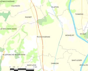
Razimet (Razimet)

- commune in Lot-et-Garonne, France
- Country:

- Postal Code: 47160
- Coordinates: 44° 21' 8" N, 0° 14' 5" E


- GPS tracks (wikiloc): [Link]
- Area: 7.18 sq km
- Population: 323
- Wikipedia en: wiki(en)
- Wikipedia: wiki(fr)
- Wikidata storage: Wikidata: Q975337
- Wikipedia Commons Category: [Link]
- Freebase ID: [/m/03qm2k3]
- GeoNames ID: Alt: [6435043]
- SIREN number: [214702201]
- BnF ID: [15261301v]
- INSEE municipality code: 47220
Shares border with regions:

Puch-d'Agenais
- commune in Lot-et-Garonne, France
- Country:
- Postal Code: 47160
- Coordinates: 44° 19' 43" N, 0° 14' 36" E
- GPS tracks (wikiloc): [Link]
- Area: 23 sq km
- Population: 705


Villeton
- commune in Lot-et-Garonne, France
- Country:
- Postal Code: 47400
- Coordinates: 44° 21' 44" N, 0° 16' 18" E
- GPS tracks (wikiloc): [Link]
- Area: 10.24 sq km
- Population: 460
Calonges
- commune in Lot-et-Garonne, France
- Country:
- Postal Code: 47430
- Coordinates: 44° 22' 26" N, 0° 14' 27" E
- GPS tracks (wikiloc): [Link]
- Area: 15.99 sq km
- Population: 625
- Web site: [Link]
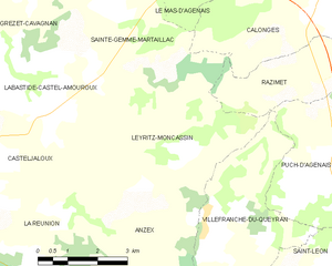
Leyritz-Moncassin
- commune in Lot-et-Garonne, France
- Country:
- Postal Code: 47700
- Coordinates: 44° 19' 38" N, 0° 9' 39" E
- GPS tracks (wikiloc): [Link]
- Area: 20.24 sq km
- Population: 214