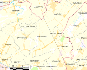
Richebourg (Richebourg)
- commune in Pas-de-Calais, France
- Country:

- Postal Code: 62136
- Coordinates: 50° 34' 45" N, 2° 44' 22" E


- GPS tracks (wikiloc): [Link]
- Area: 17.31 sq km
- Population: 2590
- Web site: http://www.richebourg62.com
- Wikipedia en: wiki(en)
- Wikipedia: wiki(fr)
- Wikidata storage: Wikidata: Q495705
- Wikipedia Commons Category: [Link]
- Freebase ID: [/m/03ck7fy]
- GeoNames ID: Alt: [6617296]
- SIREN number: [216207068]
- BnF ID: [15269147j]
- PACTOLS thesaurus ID: [pcrt3ZMVK9vcSD]
- INSEE municipality code: 62706
Shares border with regions:


Violaines
- commune in Pas-de-Calais, France
- Country:

- Postal Code: 62138
- Coordinates: 50° 32' 27" N, 2° 47' 20" E


- GPS tracks (wikiloc): [Link]
- Area: 10.01 sq km
- Population: 3612
- Web site: [Link]


Vieille-Chapelle
- commune in Pas-de-Calais, France
- Country:

- Postal Code: 62136
- Coordinates: 50° 35' 30" N, 2° 42' 20" E


- GPS tracks (wikiloc): [Link]
- Area: 3.41 sq km
- Population: 792


Neuve-Chapelle
- commune in Pas-de-Calais, France
- Country:

- Postal Code: 62840
- Coordinates: 50° 35' 2" N, 2° 46' 49" E


- GPS tracks (wikiloc): [Link]
- Area: 1.86 sq km
- Population: 1394


Lorgies
- commune in Pas-de-Calais, France
- Country:

- Postal Code: 62840
- Coordinates: 50° 34' 5" N, 2° 47' 26" E


- GPS tracks (wikiloc): [Link]
- Area: 6.84 sq km
- Population: 1585
- Web site: [Link]


Lestrem
- commune in Pas-de-Calais, France
- Country:

- Postal Code: 62136
- Coordinates: 50° 37' 20" N, 2° 41' 6" E


- GPS tracks (wikiloc): [Link]
- Area: 21.15 sq km
- Population: 4441
- Web site: [Link]


Festubert
- commune in Pas-de-Calais, France
- Country:

- Postal Code: 62149
- Coordinates: 50° 32' 36" N, 2° 44' 12" E


- GPS tracks (wikiloc): [Link]
- Area: 7.64 sq km
- Population: 1319
- Web site: [Link]


Laventie
- commune in Pas-de-Calais, France
- Country:

- Postal Code: 62840
- Coordinates: 50° 37' 39" N, 2° 46' 16" E


- GPS tracks (wikiloc): [Link]
- Area: 18.13 sq km
- Population: 4982
- Web site: [Link]


La Gorgue
- commune in Nord, France
- Country:

- Postal Code: 59253
- Coordinates: 50° 38' 18" N, 2° 42' 51" E


- GPS tracks (wikiloc): [Link]
- Area: 15.03 sq km
- Population: 5704
- Web site: [Link]


La Couture
- commune in Pas-de-Calais, France
- Country:

- Postal Code: 62136
- Coordinates: 50° 34' 53" N, 2° 42' 43" E


- GPS tracks (wikiloc): [Link]
- Area: 13.52 sq km
- Population: 2799
- Web site: [Link]
