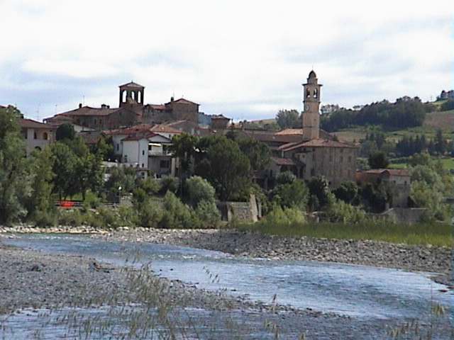
Rivergaro (Rivergaro)
.svg)
- Italian comune
 Hiking in Rivergaro
Rivergaro is a charming village located near the Trebbia River in the Emilia-Romagna region of Italy. The area offers beautiful landscapes, rolling hills, and ample opportunities for hiking. Here are some insights about hiking in Rivergaro:
Scenic Trails
-
Trebbia River Trails: The banks of the Trebbia River provide a variety of trails ranging from easy walks to more challenging hikes. Enjoy stunning views, historical landmarks, and the lush countryside.
-
Hiking in the Apennines: The nearby Apennine mountains are perfect for those looking for more challenging terrains. You can find numerous trails leading you through forests, up mountains, and to panoramic viewpoints.
-
Nature Reserves: Some trails may take you to nearby nature reserves where you can observe local flora and fauna, with opportunities for wildlife spotting.
Trail Difficulty
- Easy: Generally flat trails along the river or gentle slopes suitable for families and beginners.
- Moderate to Challenging: Trails that involve elevation changes, rocky terrains, or longer distances, recommended for more experienced hikers.
Recommendations
- What to Bring: Make sure to have appropriate hiking gear (sturdy shoes, weather-appropriate clothing), water, snacks, and a map.
- Best Time to Visit: Spring and early autumn are ideal for hiking in Rivergaro. The weather is usually mild, and the natural surroundings are vibrant and beautiful.
Safety Tips
- Always inform someone about your hiking plans.
- Check the weather forecast and local conditions before hiking.
- Stick to marked trails to stay safe and protect the environment.
Local Culture
While hiking in Rivergaro, take time to enjoy the local culture. You might encounter local villages, traditional Italian cuisine, and friendly locals who share a love for the outdoors.
Whether you are a seasoned hiker or just looking for a leisurely walk, Rivergaro offers a delightful escape into nature with its picturesque landscapes and tranquil atmosphere.
- Country:

- Postal Code: 29029
- Local Dialing Code: 0523
- Licence Plate Code: PC
- Coordinates: 44° 54' 0" N, 9° 36' 0" E


- GPS tracks (wikiloc): [Link]
- AboveSeaLevel: 140 м m
- Area: 43.83 sq km
- Population: 7066
- Web site: http://www.comune.rivergaro.pc.it/
- Wikipedia en: wiki(en)
- Wikipedia: wiki(it)
- Wikidata storage: Wikidata: Q102958
- Wikipedia Commons Category: [Link]
- Freebase ID: [/m/0gkd52]
- GeoNames ID: Alt: [6536339]
- VIAF ID: Alt: [244333008]
- OSM relation ID: [43813]
- UN/LOCODE: [ITRGR]
- Digital Atlas of the Roman Empire ID: [22876]
- ISTAT ID: 033038
- Italian cadastre code: H350
Shares border with regions:


Gazzola
- Italian comune
Hiking in Gazzola
Gazzola is a charming area located in the Emilia-Romagna region of Italy, not far from the city of Piacenza. While it's not as widely recognized as some major hiking destinations, it offers a variety of scenic trails and picturesque landscapes that make for a delightful outdoor experience....
- Country:
- Postal Code: 29010
- Local Dialing Code: 0523
- Licence Plate Code: PC
- Coordinates: 44° 57' 36" N, 9° 32' 56" E
- GPS tracks (wikiloc): [Link]
- AboveSeaLevel: 146 м m
- Area: 44.48 sq km
- Population: 2052
- Web site: [Link]


Gossolengo
- Italian comune
Hiking in Gossolengo
Gossolengo is a charming village located in the province of Piacenza, in the Emilia-Romagna region of Italy. While Gossolengo itself is small, it is surrounded by beautiful natural landscapes, making it a great starting point for various hiking adventures. Here are some details to consider if you're planning to hike in and around Gossolengo:...
- Country:
- Postal Code: 29020
- Local Dialing Code: 0523
- Licence Plate Code: PC
- Coordinates: 45° 0' 0" N, 9° 37' 0" E
- GPS tracks (wikiloc): [Link]
- AboveSeaLevel: 86 м m
- Area: 31.1 sq km
- Population: 5652
- Web site: [Link]


Podenzano
- Italian comune
Hiking in Podenzano
Podenzano is a charming village situated in the Emilia-Romagna region of Italy, not far from the city of Piacenza. The area offers beautiful landscapes and several opportunities for hiking enthusiasts. Here’s what you can expect when hiking in and around Podenzano:...
- Country:
- Postal Code: 29027
- Local Dialing Code: 0523
- Licence Plate Code: PC
- Coordinates: 44° 57' 0" N, 9° 41' 0" E
- GPS tracks (wikiloc): [Link]
- AboveSeaLevel: 118 м m
- Area: 44.34 sq km
- Population: 9144
- Web site: [Link]


Ponte dell'Olio
- Italian comune
Hiking in Ponte dell'Olio
Ponte dell'Olio is a charming village located in the province of Piacenza, in the Emilia-Romagna region of Italy. Known for its scenic landscapes and rolling hills, it offers various hiking opportunities that cater to different skill levels....
- Country:
- Postal Code: 29028
- Local Dialing Code: 0523
- Licence Plate Code: PC
- Coordinates: 44° 52' 0" N, 9° 38' 0" E
- GPS tracks (wikiloc): [Link]
- AboveSeaLevel: 217 м m
- Area: 43.92 sq km
- Population: 4691
- Web site: [Link]
Travo
- Italian comune
Hiking in Travo
Travo, located in the Corsica region of France, offers a unique blend of scenic beauty, rich history, and outdoor adventures for hiking enthusiasts. Here are some key points about hiking in and around Travo:...
- Country:
- Postal Code: 29020
- Local Dialing Code: 0523
- Licence Plate Code: PC
- Coordinates: 44° 52' 0" N, 9° 33' 0" E
- GPS tracks (wikiloc): [Link]
- AboveSeaLevel: 171 м m
- Area: 81.01 sq km
- Population: 2121
- Web site: [Link]


Vigolzone
- Italian comune
Hiking in Vigolzone
Vigolzone is a charming village located in the Emilia-Romagna region of Italy, offering beautiful landscapes and hiking opportunities for outdoor enthusiasts. Here are some key points about hiking in Vigolzone:...
- Country:
- Postal Code: 29020
- Local Dialing Code: 0523
- Licence Plate Code: PC
- Coordinates: 44° 55' 0" N, 9° 40' 0" E
- GPS tracks (wikiloc): [Link]
- AboveSeaLevel: 151 м m
- Area: 42.04 sq km
- Population: 4294
- Web site: [Link]