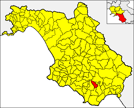
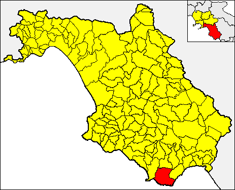
Roccagloriosa (Roccagloriosa)

- Italian comune
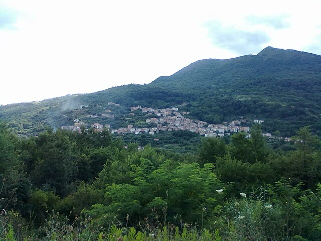
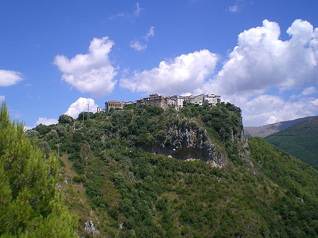
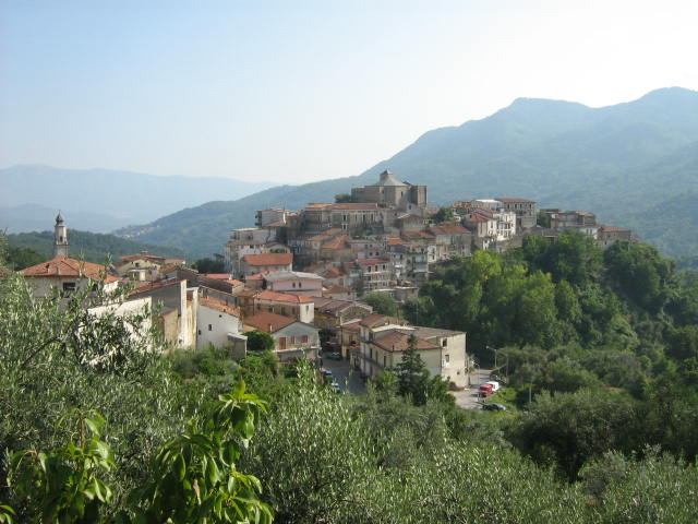
 Hiking in Roccagloriosa
Roccagloriosa, located in the Campania region of Italy, is a lesser-known but stunning destination for hiking enthusiasts. Nestled in the Cilento and Vallo di Diano National Park, this picturesque village offers a unique combination of natural beauty, historical ruins, and a rich local culture.
Hiking Trails:
-
Sentiero del Parco: This trail meanders through the lush landscapes of the national park, showcasing diverse flora and fauna, panoramic views of the surrounding mountains, and opportunities to spot wildlife.
-
Historical Trails: There are several routes that take you past the ancient ruins of Roccagloriosa, where you can explore remnants of old churches and cottages, while soaking in the history and culture of the area.
-
Cilento Coast Trails: If you're willing to venture a bit further, the trails leading down towards the coast provide breathtaking views of the Tyrrhenian Sea and the opportunity to swim in its clear waters.
Best Time to Hike:
- Spring (April to June) and Fall (September to October) are the best times for hiking in Roccagloriosa. During these seasons, the weather is mild, and the landscapes are rich with wildflowers or vibrant autumn colors.
What to Bring:
- Hiking Boots: Ensure you have sturdy footwear suitable for rocky and uneven terrain.
- Water: Hydration is crucial, so bring enough for your hike.
- Snacks: Energy bars or local treats can keep your energy up during the hike.
- Map or GPS: Navigation tools are essential, especially on less-marked trails.
- Sun Protection and First Aid Kit: Sunscreen, hats, and a basic first aid kit are recommended for safety.
Local Attractions:
- After your hike, consider visiting the charming village of Roccagloriosa itself, known for its warm hospitality, delicious local cuisine, and opportunities to experience traditional Italian culture.
Important Tips:
- Always check the weather before heading out on your hike.
- Inform someone about your hiking plans and estimated return time for safety.
- Respect nature and local regulations, staying on marked trails and not disturbing wildlife.
Hiking in Roccagloriosa offers a unique blend of adventure, culture, and stunning scenery, making it a rewarding experience for all those who venture into this hidden gem in Italy.
- Country:

- Postal Code: 84060
- Local Dialing Code: 0974
- Licence Plate Code: SA
- Coordinates: 40° 7' 0" N, 15° 26' 0" E


- GPS tracks (wikiloc): [Link]
- AboveSeaLevel: 430 м m
- Area: 40.56 sq km
- Population: 1698
- Web site: http://www.comune.roccagloriosa.sa.it
- Wikipedia en: wiki(en)
- Wikipedia: wiki(it)
- Wikidata storage: Wikidata: Q81446
- Wikipedia Commons Category: [Link]
- Freebase ID: [/m/0frgj9]
- GeoNames ID: Alt: [6537410]
- BnF ID: [12302728r]
- VIAF ID: Alt: [130323329]
- OSM relation ID: [40245]
- GND ID: Alt: [4500526-6]
- Library of Congress authority ID: Alt: [n91104358]
- PACTOLS thesaurus ID: [pcrtAUgjsB2aU2]
- SUDOC authorities ID: [031898823]
- Digital Atlas of the Roman Empire ID: [25285]
- ISTAT ID: 065107
- Italian cadastre code: H412
Shares border with regions:

Laurito
- Italian comune
Hiking in Laurito
Laurito is a charming village located in the Campania region of Italy, nestled in the mountains of the Cilento and Vallo di Diano National Park. This area is known for its stunning landscapes, rich biodiversity, and historical significance....
- Country:
- Postal Code: 84050
- Local Dialing Code: 0974
- Licence Plate Code: SA
- Coordinates: 40° 10' 0" N, 15° 24' 0" E
- GPS tracks (wikiloc): [Link]
- AboveSeaLevel: 475 м m
- Area: 20.22 sq km
- Population: 782
- Web site: [Link]

Alfano
- Italian comune
Hiking in Alfano
Alfano is a small yet fascinating area located in the Campania region of Italy, primarily known for its picturesque landscapes, historical sites, and connection to nature. When it comes to hiking in and around Alfano, there are several key points to consider:...
- Country:
- Postal Code: 84040
- Local Dialing Code: 0974
- Licence Plate Code: SA
- Coordinates: 40° 10' 39" N, 15° 25' 29" E
- GPS tracks (wikiloc): [Link]
- AboveSeaLevel: 250 м m
- Area: 4.82 sq km
- Population: 1011
- Web site: [Link]
Camerota
- Italian comune
Hiking in Camerota
Camerota, located in the Campania region of Italy, is renowned for its stunning natural beauty, picturesque landscapes, and diverse hiking opportunities. It is part of the Cilento and Vallo di Diano National Park, a UNESCO World Heritage site that boasts an impressive variety of flora and fauna, along with captivating coastal views and rugged mountain trails....
- Country:
- Postal Code: 84059; 84050; 84040
- Local Dialing Code: 0974
- Licence Plate Code: SA
- Coordinates: 40° 1' 59" N, 15° 22' 12" E
- GPS tracks (wikiloc): [Link]
- AboveSeaLevel: 422 м m
- Area: 70.58 sq km
- Population: 7107
- Web site: [Link]


Celle di Bulgheria
- Italian comune
Hiking in Celle di Bulgheria
Celle di Bulgheria, a charming village located in the Cilento and Vallo di Diano National Park in southern Italy, offers a variety of hiking opportunities that cater to both novice and experienced hikers. Here are some key points to consider when hiking in this beautiful area:...
- Country:
- Postal Code: 84040
- Local Dialing Code: 0974
- Licence Plate Code: SA
- Coordinates: 40° 6' 0" N, 15° 24' 0" E
- GPS tracks (wikiloc): [Link]
- AboveSeaLevel: 234 м m
- Area: 31.62 sq km
- Population: 1861
- Web site: [Link]

Rofrano
- Italian comune
Hiking in Rofrano
Rofrano, a picturesque village in the Campania region of southern Italy, is surrounded by the stunning landscapes of the Cilento and Vallo di Diano National Park. This area is rich in natural beauty, offering a variety of hiking opportunities suitable for different skill levels....
- Country:
- Postal Code: 84070
- Local Dialing Code: 0974
- Licence Plate Code: SA
- Coordinates: 40° 13' 0" N, 15° 26' 0" E
- GPS tracks (wikiloc): [Link]
- AboveSeaLevel: 450 м m
- Area: 63.59 sq km
- Population: 1509
- Web site: [Link]


San Giovanni a Piro
- Italian comune
Hiking in San Giovanni a Piro
San Giovanni a Piro is a picturesque town located in the Campania region of Italy, near the Cilento National Park. It offers a range of hiking opportunities that allow you to explore its stunning natural landscapes, coastal views, and rich biodiversity....
- Country:
- Postal Code: 84070
- Local Dialing Code: 0974
- Licence Plate Code: SA
- Coordinates: 40° 3' 0" N, 15° 26' 0" E
- GPS tracks (wikiloc): [Link]
- AboveSeaLevel: 450 м m
- Area: 37.9 sq km
- Population: 3763
- Web site: [Link]
Torre Orsaia
- Italian comune
Hiking in Torre Orsaia
Torre Orsaia, located in the Campania region of southern Italy, is a hidden gem nestled in the stunning scenery of the Cilento and Vallo di Diano National Park. This area is known for its rich biodiversity, rugged terrain, and diverse hiking opportunities, making it an excellent destination for outdoor enthusiasts....
- Country:
- Postal Code: 84077
- Local Dialing Code: 0974
- Licence Plate Code: SA
- Coordinates: 40° 8' 0" N, 15° 28' 0" E
- GPS tracks (wikiloc): [Link]
- AboveSeaLevel: 295 м m
- Area: 21.03 sq km
- Population: 2082
- Web site: [Link]