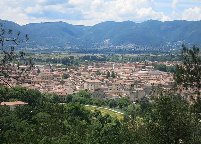
Roccantica (Roccantica)
.svg)
- Italian comune
 Hiking in Roccantica
Roccantica, a charming village located in the Lazio region of Italy, offers a variety of hiking opportunities amidst breathtaking landscapes rich in history and nature. The area is characterized by its rolling hills, ancient forests, and picturesque views of the surrounding countryside, making it an appealing destination for both novice and experienced hikers.
Hiking Trails
-
Sentiero del Bivio: This trail takes you through beautiful woodlands and offers a moderate hike suitable for families. It's well-marked and provides great views of the surrounding valleys.
-
Roccantica to Mount Soratte Trail: This more challenging hike leads you towards Mount Soratte, offering panoramic vistas. The trail is rugged, so good footwear is essential. Look out for local flora and fauna along the way.
-
Ancient Paths: Exploring the historical paths that connect Roccantica to nearby towns can be an enriching experience. These trails often reveal remnants of ancient Roman roads.
Tips for Hiking in Roccantica
- Best Time to Hike: The ideal seasons for hiking in Roccantica are spring (April to June) and autumn (September to October) when the weather is mild and the scenery is vibrant.
- Water and Snacks: Always carry sufficient water and some snacks, especially on longer hikes.
- Footwear: Wear sturdy hiking boots or shoes with good traction, as some trails can be uneven and rocky.
- Local Maps: It's advisable to have a local map or GPS app, as trails may not always be well-marked.
Safety Considerations
- Weather Awareness: Check the weather forecast before heading out, as conditions can change rapidly in mountainous areas.
- Tell Someone Your Plans: Inform a friend or family member about your hiking route and expected return time, especially if hiking alone.
Nearby Attractions
After your hikes, you can explore the quaint village of Roccantica itself, with its small shops, local eateries, and historic sites. Additionally, consider visiting nearby towns like Civita Castellana or Farfa Abbey, which are rich in cultural heritage.
Hiking in Roccantica is not just about the physical activity; it's also an opportunity to connect with nature and experience the authentic Italian countryside. Enjoy your adventure!
- Country:

- Postal Code: 02040
- Local Dialing Code: 0765
- Licence Plate Code: RI
- Coordinates: 42° 19' 0" N, 12° 42' 0" E


- GPS tracks (wikiloc): [Link]
- AboveSeaLevel: 457 м m
- Area: 16.72 sq km
- Population: 552
- Web site: http://www.comunediroccantica.it/
- Wikipedia en: wiki(en)
- Wikipedia: wiki(it)
- Wikidata storage: Wikidata: Q224439
- Wikipedia Commons Gallery: [Link]
- Wikipedia Commons Category: [Link]
- Freebase ID: [/m/0gm685]
- GeoNames ID: Alt: [6538661]
- VIAF ID: Alt: [243218271]
- OSM relation ID: [41949]
- ISTAT ID: 057061
- Italian cadastre code: H427
Shares border with regions:

Rieti
- Italian comune
Hiking in Rieti
Rieti, located in the Lazio region of Italy, is a wonderful destination for hiking enthusiasts. This area is characterized by its stunning natural landscapes, rich history, and diverse wildlife. Here are some key points about hiking in Rieti:...
- Country:
- Postal Code: 02100
- Local Dialing Code: 0746
- Licence Plate Code: RI
- Coordinates: 42° 24' 16" N, 12° 51' 24" E
- GPS tracks (wikiloc): [Link]
- AboveSeaLevel: 405 м m
- Area: 206.46 sq km
- Population: 47436
- Web site: [Link]


Cantalupo in Sabina
- Italian comune
Hiking in Cantalupo in Sabina
Cantalupo in Sabina is a picturesque village located in the Sabina region of the Lazio region in Italy. Nestled in the hills, it's surrounded by beautiful landscapes, offering various hiking opportunities for nature lovers and outdoor enthusiasts. Here’s what you need to know about hiking in this area:...
- Country:
- Postal Code: 02040
- Local Dialing Code: 0765
- Licence Plate Code: RI
- Coordinates: 42° 18' 0" N, 12° 39' 0" E
- GPS tracks (wikiloc): [Link]
- AboveSeaLevel: 297 м m
- Area: 10.62 sq km
- Population: 1682
- Web site: [Link]


Casperia
- Italian comune
Hiking in Casperia
Casperia is a beautiful medieval village located in the Sabina region of Italy, known for its stunning landscapes, historical architecture, and a peaceful atmosphere. Hiking in and around Casperia offers a blend of natural beauty and historical sites, making it an enriching outdoor experience....
- Country:
- Postal Code: 02041
- Local Dialing Code: 0765
- Coordinates: 42° 20' 0" N, 12° 40' 0" E
- GPS tracks (wikiloc): [Link]
- AboveSeaLevel: 397 м m
- Area: 25.31 sq km
- Population: 1257
- Web site: [Link]
Monte San Giovanni in Sabina
- Italian comune
Hiking in Monte San Giovanni in Sabina
Monte San Giovanni in Sabina is a beautiful area located in the Sabina region of Italy, known for its stunning landscapes, rich history, and charming villages. Hiking in this area offers a unique opportunity to explore both nature and culture. Here are some key points about hiking in Monte San Giovanni in Sabina:...
- Country:
- Postal Code: 02040
- Local Dialing Code: 0765
- Licence Plate Code: RI
- Coordinates: 42° 20' 0" N, 12° 47' 0" E
- GPS tracks (wikiloc): [Link]
- AboveSeaLevel: 728 м m
- Area: 30.76 sq km
- Population: 681
- Web site: [Link]


Poggio Catino
- Italian comune
Hiking in Poggio Catino
Poggio Catino is a charming village located in the province of Rieti in the Lazio region of Italy. It is surrounded by beautiful hills and offers a variety of scenic hiking opportunities that cater to different levels of experience. Here are some highlights and tips for hiking in and around Poggio Catino:...
- Country:
- Postal Code: 02040
- Local Dialing Code: 0765
- Licence Plate Code: RI
- Coordinates: 42° 18' 0" N, 12° 42' 0" E
- GPS tracks (wikiloc): [Link]
- AboveSeaLevel: 387 м m
- Area: 14.98 sq km
- Population: 1288
- Web site: [Link]


Salisano
- Italian comune
Hiking in Salisano
Salisano, a charming village in the Lazio region of Italy, is located near the beautiful Sabine Hills and offers outdoor enthusiasts a variety of hiking opportunities. Here are some highlights and tips for hiking in Salisano:...
- Country:
- Postal Code: 02040
- Local Dialing Code: 0765
- Licence Plate Code: RI
- Coordinates: 42° 16' 0" N, 12° 45' 0" E
- GPS tracks (wikiloc): [Link]
- AboveSeaLevel: 460 м m
- Area: 17.6 sq km
- Population: 550
- Web site: [Link]