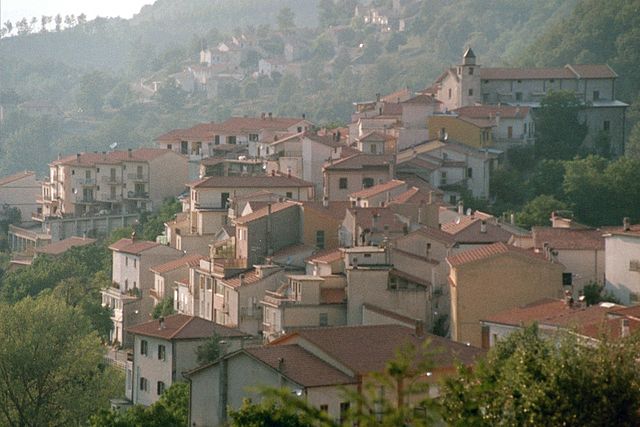
Rocchetta a Volturno (Rocchetta a Volturno)
.svg)
- Italian comune
 Hiking in Rocchetta a Volturno
Rocchetta a Volturno is a picturesque village located in the region of Molise in Italy, surrounded by the scenic landscapes of the Apennine Mountains. The area offers a variety of hiking opportunities for both beginners and experienced hikers, with trails that showcase its natural beauty, historical sites, and local wildlife.
Hiking Highlights in Rocchetta a Volturno:
-
Natural Scenery: The region is characterized by lush forests, rolling hills, and panoramic views of the Volturno River valley. The vibrant colors of the vegetation, especially in spring and autumn, add to the charm of the hikes.
-
Historic Sites: As you hike, you may come across several historic landmarks, including remnants of ancient castles and monasteries. The Monastery of San Domenico, situated near the village, is a notable site worth visiting.
-
Wildlife: The area is home to diverse flora and fauna. Keep an eye out for various bird species, animals like deer and foxes, and stunning wildflowers, especially in the spring.
-
Recommended Trails:
- Trail to Monte Meta: This trail offers a challenging hike with rewarding views at the summit. It is well-marked and takes you through dense forests.
- Valle del Volturno Trail: Following the Volturno River, this trail is less strenuous and ideal for families or those looking for a leisurely walk. It offers enchanting landscapes and tranquil spots for picnics.
-
Difficulty Levels: Trails around Rocchetta a Volturno vary in difficulty. Always assess your fitness level and experience before choosing a trail. It’s advisable to start with easier paths if you’re new to hiking.
-
Best Time to Hike: The best time to hike in the region is during spring (April to June) and fall (September to October) when the weather is pleasant, and the landscapes are particularly beautiful.
-
Local Guidance: Consider hiring a local guide or joining a hiking group to enhance your experience. They can provide insights into the area’s ecology, history, and geology.
Tips for Hiking in Rocchetta a Volturno:
- Dress Appropriately: Wear layered clothing suitable for changing weather conditions and sturdy hiking boots.
- Stay Hydrated: Carry enough water, especially on longer hikes.
- Respect Nature: Follow Leave No Trace principles to help preserve the beauty and integrity of the trails.
- Always Inform Someone: Let someone know your hiking plans and expected return time for safety.
Overall, hiking in Rocchetta a Volturno offers a mix of adventure, natural beauty, and cultural heritage, making it a delightful destination for outdoor enthusiasts.
- Country:

- Postal Code: 86070
- Local Dialing Code: 0865
- Licence Plate Code: IS
- Coordinates: 41° 37' 0" N, 14° 5' 0" E


- GPS tracks (wikiloc): [Link]
- AboveSeaLevel: 540 м m
- Area: 23.34 sq km
- Population: 1096
- Web site: http://www.comune.rocchettaavolturno.is.it/
- Wikipedia en: wiki(en)
- Wikipedia: wiki(it)
- Wikidata storage: Wikidata: Q279573
- Wikipedia Commons Category: [Link]
- Freebase ID: [/m/0gq_vk]
- GeoNames ID: Alt: [6541553]
- VIAF ID: Alt: [124641861]
- OSM relation ID: [41432]
- Library of Congress authority ID: Alt: [nb2010021041]
- ISTAT ID: 094042
- Italian cadastre code: H458
Shares border with regions:

San Biagio Saracinisco
- Italian comune
Hiking in San Biagio Saracinisco
San Biagio Saracinisco is a picturesque town located in the province of Frosinone, in the Lazio region of Italy. Nestled in the foothills of the Apennines, it offers a range of hiking opportunities that take advantage of its stunning natural landscapes, rich history, and diverse flora and fauna....
- Country:
- Postal Code: 03040
- Local Dialing Code: 0776
- Licence Plate Code: FR
- Coordinates: 41° 37' 0" N, 13° 56' 0" E
- GPS tracks (wikiloc): [Link]
- AboveSeaLevel: 836 м m
- Area: 31.21 sq km
- Population: 332
- Web site: [Link]
Vallerotonda
- Italian comune
Hiking in Vallerotonda
Vallerotonda is a charming village located in the Italian region of Lazio, within the province of Frosinone. Nestled in the scenic landscapes of the Aurunci Mountains, it's a great destination for hiking enthusiasts looking for both natural beauty and cultural experiences....
- Country:
- Postal Code: 03040
- Local Dialing Code: 0776
- Licence Plate Code: FR
- Coordinates: 41° 33' 0" N, 13° 55' 0" E
- GPS tracks (wikiloc): [Link]
- AboveSeaLevel: 620 м m
- Area: 59.66 sq km
- Population: 1532
- Web site: [Link]


Colli a Volturno
- Italian comune
Hiking in Colli a Volturno
Colli a Volturno, located in the province of Isernia in the Molise region of Italy, is a picturesque destination for hiking enthusiasts. Nestled in the Apennine mountains and surrounded by lush landscapes, it offers a range of hiking trails that cater to all skill levels, from leisurely walks to more challenging treks....
- Country:
- Postal Code: 86073
- Local Dialing Code: 0865
- Licence Plate Code: IS
- Coordinates: 41° 36' 0" N, 14° 6' 0" E
- GPS tracks (wikiloc): [Link]
- AboveSeaLevel: 411 м m
- Area: 25.25 sq km
- Population: 1339
- Web site: [Link]
Castel San Vincenzo
- Italian comune
Hiking in Castel San Vincenzo
Castel San Vincenzo, located in the province of Isernia in the Molise region of Italy, offers a beautiful hiking experience surrounded by the striking landscapes of the Mainarde mountains and the natural beauty of the region. The area is rich in history, with the remains of the ancient monastery of San Vincenzo al Volturno nearby, which adds cultural interest to your hike....
- Country:
- Postal Code: 86071
- Local Dialing Code: 0865
- Licence Plate Code: IS
- Coordinates: 41° 39' 0" N, 14° 4' 0" E
- GPS tracks (wikiloc): [Link]
- AboveSeaLevel: 749 м m
- Area: 21.98 sq km
- Population: 504
- Web site: [Link]


Cerro al Volturno
- Italian comune
Hiking in Cerro al Volturno
Cerro al Volturno is a picturesque area located in the province of Isernia, in the Molise region of Italy. This destination is particularly popular among hikers and nature enthusiasts due to its stunning landscapes, rich biodiversity, and cultural heritage. Here’s what you can expect when hiking in and around Cerro al Volturno:...
- Country:
- Postal Code: 86072
- Local Dialing Code: 0865
- Licence Plate Code: IS
- Coordinates: 41° 39' 0" N, 14° 8' 0" E
- GPS tracks (wikiloc): [Link]
- AboveSeaLevel: 572 м m
- Area: 23.79 sq km
- Population: 1250
- Web site: [Link]
Filignano
- Italian comune
Hiking in Filignano
Filignano is a charming hilltop village located in the Molise region of Italy, surrounded by beautiful landscapes and rich in natural beauty, making it a great destination for hiking enthusiasts. Here are some highlights and tips about hiking in and around Filignano:...
- Country:
- Postal Code: 86074
- Local Dialing Code: 0865
- Licence Plate Code: IS
- Coordinates: 41° 33' 0" N, 14° 3' 0" E
- GPS tracks (wikiloc): [Link]
- AboveSeaLevel: 460 м m
- Area: 30.88 sq km
- Population: 636
- Web site: [Link]


Scapoli
- Italian comune
Hiking in Scapoli
Scapoli is a picturesque village located in the Molise region of Italy, surrounded by the beautiful Apennine Mountains. It's known for its stunning landscapes, rich history, and cultural heritage. Hiking in and around Scapoli offers a variety of trails suitable for different skill levels, with opportunities to explore natural beauty, local wildlife, and historical sites....
- Country:
- Postal Code: 86070
- Local Dialing Code: 0865
- Licence Plate Code: IS
- Coordinates: 41° 37' 0" N, 14° 3' 0" E
- GPS tracks (wikiloc): [Link]
- AboveSeaLevel: 611 м m
- Area: 18.94 sq km
- Population: 649
- Web site: [Link]