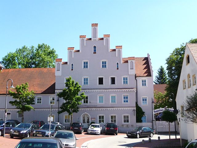
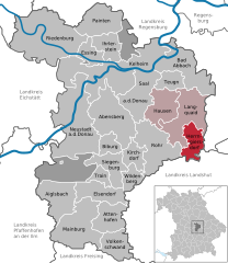
Rohr in Niederbayern (Rohr in Niederbayern)

- municipality of Germany
 Hiking in Rohr in Niederbayern
Rohr in Niederbayern, located in the Lower Bavaria region of Germany, is surrounded by beautiful landscapes that are ideal for hiking. The area features a mix of scenic forests, rolling hills, and charming villages, making it a great destination for outdoor enthusiasts.
Hiking Trails:
- Local Trails: There are several marked trails in and around Rohr that cater to various skill levels, from easy walks suitable for families to more challenging routes for experienced hikers.
- Nature and Culture: Hiking in this area often allows hikers to experience both the natural beauty of the Bavarian countryside and cultural landmarks, such as traditional farms and historic churches.
Popular Hiking Routes:
- The Bavarian Forest: A bit further out, the Bavarian Forest National Park offers extensive hiking trails and breathtaking views. Though it requires a bit of travel, it can be a rewarding day trip for avid hikers.
- Cultural Route: Some trails connect Rohr with nearby towns, allowing hikers to explore the local culture and cuisine.
Tips for Hiking in Rohr:
- Trail Maps: Always carry a trail map or use a GPS-based app to stay on track, as not all trails may be well-marked.
- Weather Conditions: Check the weather before heading out, as conditions can change rapidly in this region.
- Equipment: Wear appropriate hiking boots, clothing, and bring water and snacks, especially for longer hikes.
- Wildlife: Be aware of local wildlife and follow guidelines for safe interaction.
Local Amenities:
Rohr and neighboring villages may have small shops or cafes where hikers can replenish supplies or enjoy a meal. Make sure to check local offerings for a restful break after a day of hiking.
Overall, hiking in Rohr in Niederbayern provides a fantastic opportunity to enjoy the natural beauty and cultural richness of Bavaria. Whether you’re a seasoned hiker or just looking for a casual walk, you’re sure to find a trail that suits your needs in this picturesque area.
- Country:

- Postal Code: 93352
- Local Dialing Code: 08783
- Licence Plate Code: KEH
- Coordinates: 48° 46' 0" N, 11° 58' 0" E


- GPS tracks (wikiloc): [Link]
- AboveSeaLevel: 426 м m
- Area: 54.12 sq km
- Population: 2956
- Web site: http://www.markt-rohr.de
- Wikipedia en: wiki(en)
- Wikipedia: wiki(de)
- Wikidata storage: Wikidata: Q529002
- Wikipedia Commons Category: [Link]
- Freebase ID: [/m/02q3rvv]
- GeoNames ID: Alt: [2845750]
- VIAF ID: Alt: [236837418]
- OSM relation ID: [956646]
- GND ID: Alt: [4104949-4]
- Historical Gazetteer (GOV) ID: [ROHERNJN58XS]
- Bavarikon ID: [ODB_A00001502]
- NKCR AUT ID: [ge893094]
- German municipality key: 09273165
Shares border with regions:

Rottenburg an der Laaber
- municipality of Germany
Hiking in Rottenburg an der Laaber
Rottenburg an der Laaber is a charming town in Bavaria, Germany, that offers a variety of hiking opportunities in its surrounding landscapes. The region is known for its picturesque countryside, forested areas, and the scenic Laaber River, making it an excellent destination for hikers of all skill levels....
- Country:
- Postal Code: 84056
- Local Dialing Code: 08781
- Coordinates: 48° 42' 7" N, 12° 1' 38" E
- GPS tracks (wikiloc): [Link]
- AboveSeaLevel: 453 м m
- Area: 90.11 sq km
- Population: 7827
- Web site: [Link]


Abensberg
- town in Bavaria
Hiking in Abensberg
Abensberg, located in Bavaria, Germany, is a charming small town known for its rich history and beautiful landscapes, making it a nice destination for hikers. Here are some highlights and tips for hiking in and around Abensberg:...
- Country:
- Postal Code: 93326
- Local Dialing Code: 09443
- Licence Plate Code: KEH
- Coordinates: 48° 48' 39" N, 11° 51' 34" E
- GPS tracks (wikiloc): [Link]
- AboveSeaLevel: 370 м m
- Area: 60.27 sq km
- Population: 13540
- Web site: [Link]

Herrngiersdorf
- municipality of Germany
Hiking in Herrngiersdorf
Herrngiersdorf is a small village located in Bavaria, Germany, and it offers a wonderful experience for hiking enthusiasts. While it may not be as renowned as other hiking destinations, its surrounding landscapes provide charming trails and a glimpse into the scenic beauty of the Bavarian countryside....
- Country:
- Postal Code: 84097
- Local Dialing Code: 09452
- Licence Plate Code: KEH
- Coordinates: 48° 48' 0" N, 12° 4' 0" E
- GPS tracks (wikiloc): [Link]
- AboveSeaLevel: 405 м m
- Area: 25.08 sq km
- Population: 1010
- Web site: [Link]