Roncey (Roncey)

- commune in Manche, France
- Country:

- Postal Code: 50210
- Coordinates: 48° 59' 22" N, 1° 20' 1" E


- GPS tracks (wikiloc): [Link]
- Area: 12.15 sq km
- Population: 817
- Wikipedia en: wiki(en)
- Wikipedia: wiki(fr)
- Wikidata storage: Wikidata: Q656753
- Wikipedia Commons Category: [Link]
- Freebase ID: [/m/03nxbgx]
- Freebase ID: [/m/03nxbgx]
- GeoNames ID: Alt: [2982952]
- GeoNames ID: Alt: [2982952]
- SIREN number: [215004375]
- SIREN number: [215004375]
- BnF ID: [15262411p]
- BnF ID: [15262411p]
- VIAF ID: Alt: [238168448]
- VIAF ID: Alt: [238168448]
- Library of Congress authority ID: Alt: [n85283914]
- Library of Congress authority ID: Alt: [n85283914]
- INSEE municipality code: 50437
- INSEE municipality code: 50437
Shares border with regions:


Saint-Martin-de-Cenilly
- commune in Manche, France
- Country:
- Postal Code: 50210
- Coordinates: 48° 58' 56" N, 1° 16' 54" E
- GPS tracks (wikiloc): [Link]
- Area: 6.76 sq km
- Population: 186

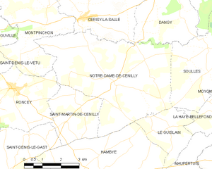
Notre-Dame-de-Cenilly
- commune in Manche, France
- Country:
- Postal Code: 50210
- Coordinates: 48° 59' 43" N, 1° 15' 29" E
- GPS tracks (wikiloc): [Link]
- Area: 25.23 sq km
- Population: 675

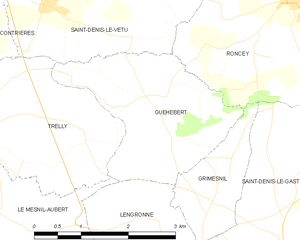
Guéhébert
- commune in Manche, France
- Country:
- Postal Code: 50210
- Coordinates: 48° 58' 12" N, 1° 22' 24" E
- GPS tracks (wikiloc): [Link]
- AboveSeaLevel: 67 м m
- Area: 6.29 sq km
- Population: 121


Saint-Denis-le-Vêtu
- commune in Manche, France
- Country:
- Postal Code: 50210
- Coordinates: 48° 59' 10" N, 1° 24' 11" E
- GPS tracks (wikiloc): [Link]
- Area: 14.08 sq km
- Population: 618


Grimesnil
- commune in Manche, France
- Country:
- Postal Code: 50450
- Coordinates: 48° 57' 14" N, 1° 21' 0" E
- GPS tracks (wikiloc): [Link]
- Area: 2.61 sq km
- Population: 62


Montpinchon
- commune in Manche, France
- Country:
- Postal Code: 50210
- Coordinates: 49° 1' 20" N, 1° 18' 36" E
- GPS tracks (wikiloc): [Link]
- Area: 16.94 sq km
- Population: 546


Saint-Denis-le-Gast
- commune in Manche, France
- Country:
- Postal Code: 50450
- Coordinates: 48° 56' 25" N, 1° 19' 46" E
- GPS tracks (wikiloc): [Link]
- Area: 16.73 sq km
- Population: 549