Rosnay-l'Hôpital (Rosnay-l'Hôpital)

- commune in Aube, France
- Country:

- Postal Code: 10500
- Coordinates: 48° 27' 34" N, 4° 30' 13" E


- GPS tracks (wikiloc): [Link]
- AboveSeaLevel: 118 м m
- Area: 12.47 sq km
- Population: 212
- Wikipedia en: wiki(en)
- Wikipedia: wiki(fr)
- Wikidata storage: Wikidata: Q1363396
- Wikipedia Commons Category: [Link]
- Freebase ID: [/m/03m8vfb]
- SIREN number: [211003157]
- BnF ID: [15246418n]
- VIAF ID: Alt: [238790799]
- INSEE municipality code: 10326
Shares border with regions:
Courcelles-sur-Voire
- commune in Aube, France
- Country:
- Postal Code: 10500
- Coordinates: 48° 28' 21" N, 4° 32' 20" E
- GPS tracks (wikiloc): [Link]
- Area: 4.9 sq km
- Population: 25

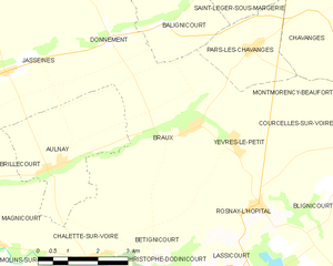
Braux
- commune in Aube, France
- Country:
- Postal Code: 10500
- Coordinates: 48° 29' 3" N, 4° 28' 18" E
- GPS tracks (wikiloc): [Link]
- AboveSeaLevel: 127 м m
- Area: 15.21 sq km
- Population: 100
Lassicourt
- commune in Aube, France
- Country:
- Postal Code: 10500
- Coordinates: 48° 26' 34" N, 4° 29' 21" E
- GPS tracks (wikiloc): [Link]
- AboveSeaLevel: 113 м m
- Area: 7.73 sq km
- Population: 65
Perthes-lès-Brienne
- commune in Aube, France
- Country:
- Postal Code: 10500
- Coordinates: 48° 25' 49" N, 4° 32' 23" E
- GPS tracks (wikiloc): [Link]
- Area: 3.63 sq km
- Population: 82


Saint-Christophe-Dodinicourt
- commune in Aube, France
- Country:
- Postal Code: 10500
- Coordinates: 48° 26' 20" N, 4° 28' 12" E
- GPS tracks (wikiloc): [Link]
- Area: 4.87 sq km
- Population: 34


Yèvres-le-Petit
- commune in Aube, France
- Country:
- Postal Code: 10500
- Coordinates: 48° 28' 43" N, 4° 29' 26" E
- GPS tracks (wikiloc): [Link]
- Area: 8.35 sq km
- Population: 61
Bétignicourt
- commune in Aube, France
- Country:
- Postal Code: 10500
- Coordinates: 48° 26' 48" N, 4° 27' 20" E
- GPS tracks (wikiloc): [Link]
- Area: 3.18 sq km
- Population: 32
Blignicourt
- commune in Aube, France
- Country:
- Postal Code: 10500
- Coordinates: 48° 27' 43" N, 4° 31' 55" E
- GPS tracks (wikiloc): [Link]
- Area: 4.27 sq km
- Population: 41