Saint-Aignan, Sarthe (Saint-Aignan)

- commune in Sarthe, France
- Country:

- Postal Code: 72110
- Coordinates: 48° 12' 57" N, 0° 20' 34" E


- GPS tracks (wikiloc): [Link]
- Area: 15.13 sq km
- Population: 274
- Wikipedia en: wiki(en)
- Wikipedia: wiki(fr)
- Wikidata storage: Wikidata: Q952806
- Wikipedia Commons Category: [Link]
- Freebase ID: [/m/03qk2sz]
- GeoNames ID: Alt: [6613685]
- SIREN number: [217202654]
- BnF ID: [15273818n]
- INSEE municipality code: 72265
Shares border with regions:

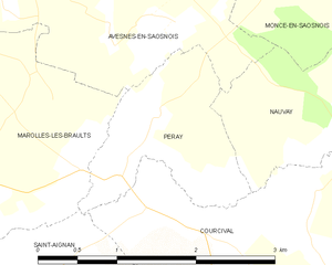
Peray
- commune in Sarthe, France
- Country:
- Postal Code: 72260
- Coordinates: 48° 14' 54" N, 0° 21' 51" E
- GPS tracks (wikiloc): [Link]
- Area: 2.45 sq km
- Population: 65


Jauzé
- commune in Sarthe, France
- Country:
- Postal Code: 72110
- Coordinates: 48° 12' 41" N, 0° 22' 38" E
- GPS tracks (wikiloc): [Link]
- Area: 5.68 sq km
- Population: 86


Mézières-sur-Ponthouin
- commune in Sarthe, France
- Country:
- Postal Code: 72290
- Coordinates: 48° 11' 35" N, 0° 17' 55" E
- GPS tracks (wikiloc): [Link]
- Area: 17.88 sq km
- Population: 692
- Web site: [Link]
Dissé-sous-Ballon
- commune in Sarthe, France
- Country:
- Postal Code: 72260
- Coordinates: 48° 14' 14" N, 0° 17' 51" E
- GPS tracks (wikiloc): [Link]
- Area: 3.55 sq km
- Population: 140

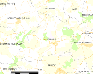
Courcemont
- commune in Sarthe, France
- Country:
- Postal Code: 72110
- Coordinates: 48° 10' 24" N, 0° 21' 8" E
- GPS tracks (wikiloc): [Link]
- Area: 19.26 sq km
- Population: 687
- Web site: [Link]


Courcival
- commune in Sarthe, France
- Country:
- Postal Code: 72110
- Coordinates: 48° 13' 45" N, 0° 23' 49" E
- GPS tracks (wikiloc): [Link]
- Area: 8.94 sq km
- Population: 93


Briosne-lès-Sables
- commune in Sarthe, France
- Country:
- Postal Code: 72110
- Coordinates: 48° 10' 27" N, 0° 23' 44" E
- GPS tracks (wikiloc): [Link]
- Area: 9.85 sq km
- Population: 570


Marolles-les-Braults
- commune in Sarthe, France
- Country:
- Postal Code: 72260
- Coordinates: 48° 15' 8" N, 0° 18' 51" E
- GPS tracks (wikiloc): [Link]
- Area: 20.64 sq km
- Population: 2067
- Web site: [Link]