Saint-Bômer-les-Forges (Saint-Bômer-les-Forges)

- commune in Orne, France
- Country:

- Postal Code: 61700
- Coordinates: 48° 38' 38" N, 0° 38' 0" E


- GPS tracks (wikiloc): [Link]
- Area: 31.08 sq km
- Population: 1043
- Web site: http://www.saint-bomer-les-forges.fr/
- Wikipedia en: wiki(en)
- Wikipedia: wiki(fr)
- Wikidata storage: Wikidata: Q1096987
- Wikipedia Commons Category: [Link]
- Freebase ID: [/m/03x_xn6]
- Freebase ID: [/m/03x_xn6]
- GeoNames ID: Alt: [6439231]
- GeoNames ID: Alt: [6439231]
- SIREN number: [216103697]
- SIREN number: [216103697]
- BnF ID: [15268299t]
- BnF ID: [15268299t]
- INSEE municipality code: 61369
- INSEE municipality code: 61369
Shares border with regions:

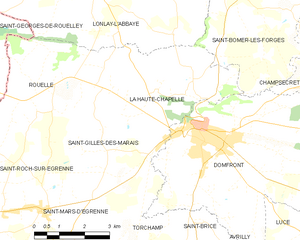
La Haute-Chapelle
- former commune in Orne, France
- Country:
- Postal Code: 61700
- Coordinates: 48° 36' 18" N, 0° 40' 17" E
- GPS tracks (wikiloc): [Link]
- Area: 19.31 sq km
- Population: 597


Le Châtellier
- commune in Orne, France
- Country:
- Postal Code: 61450
- Coordinates: 48° 40' 33" N, 0° 34' 54" E
- GPS tracks (wikiloc): [Link]
- Area: 8.18 sq km
- Population: 420


Banvou
- commune in Orne, France
- Country:
- Postal Code: 61450
- Coordinates: 48° 39' 54" N, 0° 33' 11" E
- GPS tracks (wikiloc): [Link]
- Area: 12.98 sq km
- Population: 633


Lonlay-l'Abbaye
- commune in Orne, France
- Country:
- Postal Code: 61700
- Coordinates: 48° 38' 48" N, 0° 42' 36" E
- GPS tracks (wikiloc): [Link]
- Area: 53.41 sq km
- Population: 1142
- Web site: [Link]

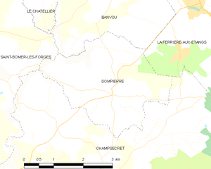
Dompierre
- commune in Orne, France
- Country:
- Postal Code: 61700
- Coordinates: 48° 37' 56" N, 0° 33' 7" E
- GPS tracks (wikiloc): [Link]
- Area: 8.56 sq km
- Population: 396

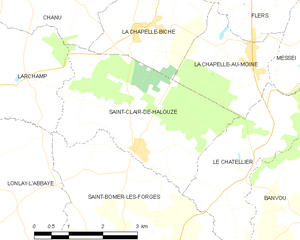
Saint-Clair-de-Halouze
- commune in Orne, France
- Country:
- Postal Code: 61490
- Coordinates: 48° 40' 45" N, 0° 37' 31" E
- GPS tracks (wikiloc): [Link]
- Area: 11.81 sq km
- Population: 869


Champsecret
- commune in Orne, France
- Country:
- Postal Code: 61700
- Coordinates: 48° 36' 33" N, 0° 33' 2" E
- GPS tracks (wikiloc): [Link]
- Area: 44.68 sq km
- Population: 934