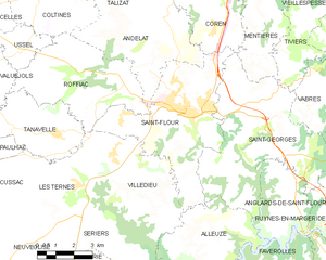
Saint-Flour (Saint-Flour)
- commune in Cantal, France
- Country:

- Postal Code: 15100
- Coordinates: 45° 2' 1" N, 3° 5' 34" E


- GPS tracks (wikiloc): [Link]
- Area: 27.14 sq km
- Population: 6630
- Web site: http://www.saint-flour.fr
- Wikipedia en: wiki(en)
- Wikipedia: wiki(fr)
- Wikidata storage: Wikidata: Q210763
- Wikipedia Commons Category: [Link]
- Freebase ID: [/m/08rgxy]
- Freebase ID: [/m/08rgxy]
- Freebase ID: [/m/08rgxy]
- Freebase ID: [/m/08rgxy]
- GeoNames ID: Alt: [2980104]
- GeoNames ID: Alt: [2980104]
- GeoNames ID: Alt: [2980104]
- GeoNames ID: Alt: [2980104]
- SIREN number: [211501879]
- SIREN number: [211501879]
- SIREN number: [211501879]
- SIREN number: [211501879]
- BnF ID: [15248357r]
- BnF ID: [15248357r]
- BnF ID: [15248357r]
- BnF ID: [15248357r]
- VIAF ID: Alt: [242132272]
- VIAF ID: Alt: [242132272]
- VIAF ID: Alt: [242132272]
- VIAF ID: Alt: [242132272]
- OSM relation ID: [135753]
- OSM relation ID: [135753]
- OSM relation ID: [135753]
- OSM relation ID: [135753]
- archINFORM location ID: [7072]
- archINFORM location ID: [7072]
- archINFORM location ID: [7072]
- archINFORM location ID: [7072]
- MusicBrainz area ID: [dbd08e4e-cb82-4c89-95a6-7c71487881e8]
- MusicBrainz area ID: [dbd08e4e-cb82-4c89-95a6-7c71487881e8]
- MusicBrainz area ID: [dbd08e4e-cb82-4c89-95a6-7c71487881e8]
- MusicBrainz area ID: [dbd08e4e-cb82-4c89-95a6-7c71487881e8]
- SUDOC authorities ID: [086198122]
- SUDOC authorities ID: [086198122]
- SUDOC authorities ID: [086198122]
- SUDOC authorities ID: [086198122]
- Digital Atlas of the Roman Empire ID: [12389]
- Digital Atlas of the Roman Empire ID: [12389]
- Digital Atlas of the Roman Empire ID: [12389]
- Digital Atlas of the Roman Empire ID: [12389]
- INSEE municipality code: 15187
- INSEE municipality code: 15187
- INSEE municipality code: 15187
- INSEE municipality code: 15187
Shares border with regions:


Coren
- commune in Cantal, France
- Country:

- Postal Code: 15100
- Coordinates: 45° 4' 38" N, 3° 6' 27" E


- GPS tracks (wikiloc): [Link]
- Area: 16.86 sq km
- Population: 419


Villedieu
- commune in Cantal, France
- Country:

- Postal Code: 15100
- Coordinates: 44° 59' 56" N, 3° 3' 51" E


- GPS tracks (wikiloc): [Link]
- Area: 18.99 sq km
- Population: 542


Alleuze
- commune in Cantal, France
- Country:

- Postal Code: 15100
- Coordinates: 44° 57' 44" N, 3° 5' 9" E


- GPS tracks (wikiloc): [Link]
- Area: 22.85 sq km
- Population: 212


Roffiac
- commune in Cantal, France
- Country:

- Postal Code: 15100
- Coordinates: 45° 3' 9" N, 3° 2' 17" E


- GPS tracks (wikiloc): [Link]
- Area: 21.26 sq km
- Population: 610


Andelat
- commune in Cantal, France
- Country:

- Postal Code: 15100
- Coordinates: 45° 3' 38" N, 3° 3' 41" E


- GPS tracks (wikiloc): [Link]
- Area: 21.05 sq km
- Population: 463


Saint-Georges
- commune in Cantal, France
- Country:

- Postal Code: 15100
- Coordinates: 45° 1' 7" N, 3° 7' 39" E


- GPS tracks (wikiloc): [Link]
- Area: 33.14 sq km
- Population: 1158
- Web site: [Link]
