Saint-Genès-Champespe (Saint-Genès-Champespe)

- commune in Puy-de-Dôme, France
- Country:

- Postal Code: 63850
- Coordinates: 45° 25' 8" N, 2° 43' 24" E


- GPS tracks (wikiloc): [Link]
- Area: 32.33 sq km
- Population: 224
- Wikipedia en: wiki(en)
- Wikipedia: wiki(fr)
- Wikidata storage: Wikidata: Q541580
- Wikipedia Commons Category: [Link]
- Freebase ID: [/m/03ql2cb]
- SIREN number: [216303461]
- BnF ID: [152696964]
- INSEE municipality code: 63346
Shares border with regions:

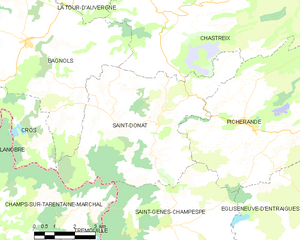
Saint-Donat
- commune in Puy-de-Dôme, France
- Country:
- Postal Code: 63680
- Coordinates: 45° 28' 9" N, 2° 43' 7" E
- GPS tracks (wikiloc): [Link]
- Area: 33.27 sq km
- Population: 224

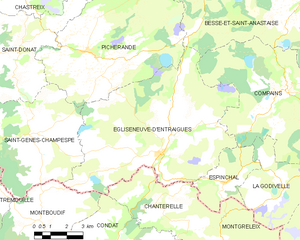
Égliseneuve-d'Entraigues
- commune in Puy-de-Dôme, France
- Country:
- Postal Code: 63850
- Coordinates: 45° 24' 29" N, 2° 49' 38" E
- GPS tracks (wikiloc): [Link]
- AboveSeaLevel: 950 м m
- Area: 56.43 sq km
- Population: 389


Trémouille
- commune in Cantal, France
- Country:
- Postal Code: 15270
- Coordinates: 45° 22' 23" N, 2° 40' 29" E
- GPS tracks (wikiloc): [Link]
- Area: 29.09 sq km
- Population: 178

Champs-sur-Tarentaine-Marchal
- commune in Cantal, France
- Country:
- Postal Code: 15270
- Coordinates: 45° 23' 45" N, 2° 33' 39" E
- GPS tracks (wikiloc): [Link]
- AboveSeaLevel: 450 м m
- Area: 60.32 sq km
- Population: 1059
Montboudif
- commune in Cantal, France
- Country:
- Postal Code: 15190
- Coordinates: 45° 22' 17" N, 2° 43' 53" E
- GPS tracks (wikiloc): [Link]
- Area: 20.42 sq km
- Population: 190


Picherande
- commune in Puy-de-Dôme, France
- Country:
- Postal Code: 63113
- Coordinates: 45° 27' 51" N, 2° 46' 1" E
- GPS tracks (wikiloc): [Link]
- Area: 44.26 sq km
- Population: 357
- Web site: [Link]