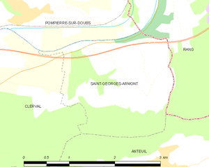
Saint-Georges-Armont (Saint-Georges-Armont)
- commune in Doubs, France
 Hiking in Saint-Georges-Armont
Saint-Georges-Armont, located in the picturesque Vosges region of France, offers a unique hiking experience amidst beautiful landscapes. The area is characterized by rolling hills, dense forests, and panoramic views of the surrounding countryside. Here are some highlights and tips for hiking in this region:
Hiking Trails
-
Marked Trails: The region has several well-marked hiking trails that cater to different skill levels. You can find short, family-friendly paths as well as more challenging routes for experienced hikers.
-
Scenic Views: Many trails offer stunning views of the Vosges mountains and the surrounding valleys. Look for lookout points along the way to take in the scenery and capture some great photographs.
-
Nature Reserves: Hikers can explore nearby nature reserves where you may encounter diverse wildlife and plant species. The flora and fauna are rich and varied, making it a great spot for nature lovers.
Preparation Tips
-
Maps and Guides: Before heading out, it's a good idea to acquire a detailed map of the area or download a hiking app that includes GPS functionality.
-
Weather: Check the weather forecast before your hike, as conditions can change rapidly in mountainous regions. Dress in layers and be prepared for sudden weather shifts.
-
Footwear: Wear sturdy hiking boots to ensure comfort and support, especially on uneven terrain.
Safety Considerations
- Stay on Marked Paths: To protect the environment and avoid getting lost, stick to designated trails.
- Bring Essentials: Always carry enough water, snacks, a first-aid kit, and sun protection.
Best Times to Hike
- Spring and Fall: These seasons are ideal for hiking in Saint-Georges-Armont due to mild temperatures and the vibrant colors of nature. Summer can also be pleasant, but be aware of higher traffic on popular trails.
Local Insights
- Cultural Attractions: After a day of hiking, consider visiting local villages to experience the culture and cuisine of the Vosges region. Traditional dishes and local products are worth exploring.
By planning ahead and respecting nature, you can enjoy a wonderful hiking experience in Saint-Georges-Armont and the Vosges mountains. Happy trails!
- Country:

- Postal Code: 25340
- Coordinates: 47° 23' 56" N, 6° 33' 25" E


- GPS tracks (wikiloc): [Link]
- Area: 4.74 sq km
- Population: 118
- Wikipedia en: wiki(en)
- Wikipedia: wiki(fr)
- Wikidata storage: Wikidata: Q996146
- Wikipedia Commons Category: [Link]
- Freebase ID: [/m/03mgy2g]
- Freebase ID: [/m/03mgy2g]
- GeoNames ID: Alt: [6429975]
- GeoNames ID: Alt: [6429975]
- SIREN number: [212505168]
- SIREN number: [212505168]
- BnF ID: [15252742k]
- BnF ID: [15252742k]
- INSEE municipality code: 25516
- INSEE municipality code: 25516
Shares border with regions:


Anteuil
- commune in Doubs, France
Anteuil is a small commune in the Doubs department in eastern France. While it might not be as widely recognized for hiking as some larger national parks or regions, it offers beautiful landscapes typical of the Jura foothills. Here are some things to consider when hiking in and around Anteuil:...
- Country:

- Postal Code: 25340
- Coordinates: 47° 23' 15" N, 6° 33' 39" E


- GPS tracks (wikiloc): [Link]
- Area: 24.29 sq km
- Population: 661


Clerval
- former commune in Doubs, France
Clerval, located in the Doubs department of the Bourgogne-Franche-Comté region in eastern France, offers a charming backdrop for hiking enthusiasts. The area is rich in natural beauty, with rolling hills, forests, and the scenic Doubs River winding through the landscape....
- Country:

- Postal Code: 25340
- Coordinates: 47° 23' 32" N, 6° 29' 51" E


- GPS tracks (wikiloc): [Link]
- Area: 11.83 sq km
- Population: 1035


Pompierre-sur-Doubs
- commune in Doubs, France
Pompierre-sur-Doubs is a picturesque village located in the Doubs department in the Bourgogne-Franche-Comté region of France. The area offers beautiful natural scenery, making it a suitable destination for hiking enthusiasts. Here are some highlights and tips for hiking in and around Pompierre-sur-Doubs:...
- Country:

- Postal Code: 25340
- Coordinates: 47° 25' 7" N, 6° 31' 27" E


- GPS tracks (wikiloc): [Link]
- Area: 8.16 sq km
- Population: 304


Rang
- commune in Doubs, France
Hiking in Rang, located in the Doubs department of France, offers a fantastic opportunity to explore the natural beauty of the Jura Mountains and the surrounding landscapes. The area is known for its stunning scenery, diverse wildlife, and numerous trails that cater to all levels of hikers....
- Country:

- Postal Code: 25250
- Coordinates: 47° 25' 35" N, 6° 33' 46" E


- GPS tracks (wikiloc): [Link]
- Area: 10.32 sq km
- Population: 420
