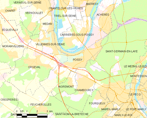
Saint-Germain-en-Laye (Saint-Germain-en-Laye)
- commune in Yvelines, France
- Country:

- Postal Code: 78100
- Coordinates: 48° 53' 47" N, 2° 5' 26" E


- GPS tracks (wikiloc): [Link]
- AboveSeaLevel: 78 м m
- Area: 48.27 sq km
- Population: 39980
- Web site: http://www.saintgermainenlaye.fr
- Wikipedia en: wiki(en)
- Wikipedia: wiki(fr)
- Wikidata storage: Wikidata: Q185075
- Wikipedia Commons Gallery: [Link]
- Wikipedia Commons Category: [Link]
- Wikipedia Commons Maps Category: [Link]
- Freebase ID: [/m/0k2fj]
- Freebase ID: [/m/0k2fj]
- Freebase ID: [/m/0k2fj]
- GeoNames ID: Alt: [2979783]
- GeoNames ID: Alt: [2979783]
- GeoNames ID: Alt: [2979783]
- SIREN number: [217805514]
- SIREN number: [217805514]
- SIREN number: [217805514]
- BnF ID: [15276089p]
- BnF ID: [15276089p]
- BnF ID: [15276089p]
- VIAF ID: Alt: [157859625]
- VIAF ID: Alt: [157859625]
- VIAF ID: Alt: [157859625]
- OSM relation ID: [75454]
- OSM relation ID: [75454]
- OSM relation ID: [75454]
- GND ID: Alt: [4116311-4]
- GND ID: Alt: [4116311-4]
- GND ID: Alt: [4116311-4]
- archINFORM location ID: [662]
- archINFORM location ID: [662]
- archINFORM location ID: [662]
- Library of Congress authority ID: Alt: [n80115548]
- Library of Congress authority ID: Alt: [n80115548]
- Library of Congress authority ID: Alt: [n80115548]
- PACTOLS thesaurus ID: [pcrtjpHFZmEWo3]
- PACTOLS thesaurus ID: [pcrtjpHFZmEWo3]
- PACTOLS thesaurus ID: [pcrtjpHFZmEWo3]
- MusicBrainz area ID: [3a84b7b0-2e32-4cf3-9b54-08741a9c59ca]
- MusicBrainz area ID: [3a84b7b0-2e32-4cf3-9b54-08741a9c59ca]
- MusicBrainz area ID: [3a84b7b0-2e32-4cf3-9b54-08741a9c59ca]
- Quora topic ID: [Saint-Germain-en-Laye]
- Quora topic ID: [Saint-Germain-en-Laye]
- Quora topic ID: [Saint-Germain-en-Laye]
- SUDOC authorities ID: [026555700]
- SUDOC authorities ID: [026555700]
- SUDOC authorities ID: [026555700]
- Encyclopædia Britannica Online ID: [place/Saint-Germain-en-Laye]
- Encyclopædia Britannica Online ID: [place/Saint-Germain-en-Laye]
- Encyclopædia Britannica Online ID: [place/Saint-Germain-en-Laye]
- EMLO location ID: [2b888dec-cbc1-4093-baa7-457cc8bc2f25]
- EMLO location ID: [2b888dec-cbc1-4093-baa7-457cc8bc2f25]
- EMLO location ID: [2b888dec-cbc1-4093-baa7-457cc8bc2f25]
- Twitter username: Alt: [StGermainLaye]
- Twitter username: Alt: [StGermainLaye]
- Twitter username: Alt: [StGermainLaye]
- NKCR AUT ID: [ge947248]
- NKCR AUT ID: [ge947248]
- NKCR AUT ID: [ge947248]
- INSEE municipality code: 78551
- INSEE municipality code: 78551
- INSEE municipality code: 78551
- US National Archives Identifier: 10046183
- US National Archives Identifier: 10046183
- US National Archives Identifier: 10046183
Shares border with regions:


Achères
- commune in Yvelines, France
- Country:

- Postal Code: 78260
- Coordinates: 48° 57' 44" N, 2° 4' 7" E


- GPS tracks (wikiloc): [Link]
- Area: 9.44 sq km
- Population: 21053
- Web site: [Link]


Le Pecq
- commune in Yvelines, France
- Country:

- Postal Code: 78230
- Coordinates: 48° 53' 48" N, 2° 6' 22" E


- GPS tracks (wikiloc): [Link]
- Area: 2.84 sq km
- Population: 16131
- Web site: [Link]


Chambourcy
- commune in Yvelines, France
- Country:

- Postal Code: 78240
- Coordinates: 48° 54' 22" N, 2° 2' 25" E


- GPS tracks (wikiloc): [Link]
- Area: 7.87 sq km
- Population: 5724


Poissy
- commune in Yvelines, France
- Country:

- Postal Code: 78300
- Coordinates: 48° 55' 44" N, 2° 2' 41" E


- GPS tracks (wikiloc): [Link]
- AboveSeaLevel: 27 м m
- Area: 13.28 sq km
- Population: 37093
- Web site: [Link]


Maisons-Laffitte
- commune in Yvelines, France
- Country:

- Postal Code: 78600
- Coordinates: 48° 56' 46" N, 2° 8' 42" E


- GPS tracks (wikiloc): [Link]
- AboveSeaLevel: 38 м m
- Area: 6.75 sq km
- Population: 23371
- Web site: [Link]


Fourqueux
- commune in Yvelines, France
- Country:

- Postal Code: 78112
- Coordinates: 48° 53' 13" N, 2° 3' 55" E


- GPS tracks (wikiloc): [Link]
- Area: 3.67 sq km
- Population: 3996


Le Mesnil-le-Roi
- commune in Yvelines, France
- Country:

- Postal Code: 78600
- Coordinates: 48° 55' 41" N, 2° 7' 21" E


- GPS tracks (wikiloc): [Link]
- AboveSeaLevel: 42 м m
- Area: 3.25 sq km
- Population: 6303
- Web site: [Link]


Mareil-Marly
- commune in Yvelines, France
- Country:

- Postal Code: 78750
- Coordinates: 48° 52' 55" N, 2° 4' 36" E


- GPS tracks (wikiloc): [Link]
- Area: 1.77 sq km
- Population: 3524
- Web site: [Link]
