Saint-Germain-le-Gaillard (Saint-Germain-le-Gaillard)

- commune in Manche, France
- Country:

- Postal Code: 50340
- Coordinates: 49° 29' 11" N, 1° 46' 56" E


- GPS tracks (wikiloc): [Link]
- Area: 13.83 sq km
- Population: 747
- Wikipedia en: wiki(en)
- Wikipedia: wiki(fr)
- Wikidata storage: Wikidata: Q745289
- Wikipedia Commons Category: [Link]
- Freebase ID: [/m/03nxbx6]
- Freebase ID: [/m/03nxbx6]
- GeoNames ID: Alt: [6435592]
- GeoNames ID: Alt: [6435592]
- SIREN number: [215004805]
- SIREN number: [215004805]
- BnF ID: [15262453m]
- BnF ID: [15262453m]
- INSEE municipality code: 50480
- INSEE municipality code: 50480
Shares border with regions:


Le Vrétot
- former commune in Manche, France
- Country:
- Postal Code: 50260
- Coordinates: 49° 27' 7" N, 1° 42' 39" E
- GPS tracks (wikiloc): [Link]
- Area: 20.56 sq km
- Population: 631


Pierreville
- commune in Manche, France
- Country:
- Postal Code: 50340
- Coordinates: 49° 28' 24" N, 1° 46' 54" E
- GPS tracks (wikiloc): [Link]
- Area: 10.11 sq km
- Population: 735


Les Pieux
- commune in Manche, France
- Country:
- Postal Code: 50340
- Coordinates: 49° 30' 47" N, 1° 48' 28" E
- GPS tracks (wikiloc): [Link]
- Area: 15.25 sq km
- Population: 3147
- Web site: [Link]


Le Rozel
- commune in Manche, France
- Country:
- Postal Code: 50340
- Coordinates: 49° 29' 13" N, 1° 49' 44" E
- GPS tracks (wikiloc): [Link]
- Area: 5.52 sq km
- Population: 250

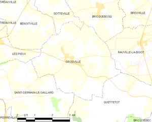
Grosville
- commune in Manche, France
- Country:
- Postal Code: 50340
- Coordinates: 49° 30' 34" N, 1° 44' 35" E
- GPS tracks (wikiloc): [Link]
- Area: 13.15 sq km
- Population: 787


Quettetot
- former commune in Manche, France
- Country:
- Postal Code: 50260
- Coordinates: 49° 29' 15" N, 1° 40' 0" E
- GPS tracks (wikiloc): [Link]
- Area: 12.43 sq km
- Population: 711