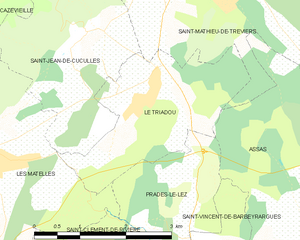
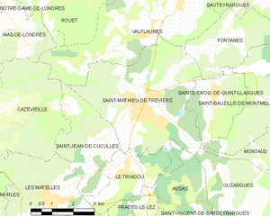
Saint-Jean-de-Cuculles (Saint-Jean-de-Cuculles)

- commune in Hérault, France
- Country:

- Postal Code: 34270
- Coordinates: 43° 45' 9" N, 3° 50' 4" E


- GPS tracks (wikiloc): [Link]
- Area: 9.09 sq km
- Population: 487
- Web site: http://www.saint-jean-de-cuculles.fr
- Wikipedia en: wiki(en)
- Wikipedia: wiki(fr)
- Wikidata storage: Wikidata: Q584908
- Wikipedia Commons Category: [Link]
- Freebase ID: [/m/03mgp72]
- Freebase ID: [/m/03mgp72]
- GeoNames ID: Alt: [6432637]
- GeoNames ID: Alt: [6432637]
- SIREN number: [213402662]
- SIREN number: [213402662]
- BnF ID: [152568675]
- BnF ID: [152568675]
- INSEE municipality code: 34266
- INSEE municipality code: 34266
Shares border with regions:


Les Matelles
- commune in Hérault, France
- Country:
- Postal Code: 34270
- Coordinates: 43° 43' 50" N, 3° 48' 32" E
- GPS tracks (wikiloc): [Link]
- Area: 16.81 sq km
- Population: 1991
- Web site: [Link]

Le Triadou
- commune in Hérault, France
- Country:
- Postal Code: 34270
- Coordinates: 43° 44' 23" N, 3° 51' 7" E
- GPS tracks (wikiloc): [Link]
- Area: 6.3 sq km
- Population: 388
- Web site: [Link]


Valflaunès
- commune in Hérault, France
- Country:
- Postal Code: 34270
- Coordinates: 43° 48' 2" N, 3° 52' 19" E
- GPS tracks (wikiloc): [Link]
- Area: 21.04 sq km
- Population: 745
- Web site: [Link]


Cazevieille
- commune in Hérault, France
- Country:
- Postal Code: 34270
- Coordinates: 43° 46' 12" N, 3° 47' 19" E
- GPS tracks (wikiloc): [Link]
- Area: 16.21 sq km
- Population: 181

Saint-Mathieu-de-Tréviers
- commune in Hérault, France
- Country:
- Postal Code: 34270
- Coordinates: 43° 46' 11" N, 3° 52' 7" E
- GPS tracks (wikiloc): [Link]
- Area: 21.92 sq km
- Population: 4688
- Web site: [Link]