Saint-Julien-en-Genevois (Saint-Julien-en-Genevois)

- commune in Haute-Savoie, France
 Hiking in Saint-Julien-en-Genevois
Saint-Julien-en-Genevois is a charming town nestled between the beautiful Jura Mountains and the French-Swiss border. It serves as an excellent base for hikers looking to explore the surrounding natural landscapes. Here’s a brief overview of hiking in the area:
Trails and Natural Attractions
-
Jura Mountains: The nearby Jura offers a variety of trails ranging from easy walks to more challenging hikes. The trails often provide stunning views of Lake Geneva, the Alps, and the surrounding valleys.
-
Parc Naturel Régional du Haut-Jura: Just a short drive away, this regional park features numerous hiking routes. You can enjoy paths that meander through forests, past pristine lakes, and over rolling hills. The park is well-marked and provides a great opportunity to see local wildlife and flora.
-
Bristling Ridge: For those who enjoy panoramic views, the hike up to Bristling Ridge (Crêt de la Neige) is highly recommended. It is one of the highest points in the Jura range and offers breathtaking vistas.
-
Local Trails: Within Saint-Julien-en-Genevois itself, there are shorter, well-maintained trails that are accessible for all fitness levels. Check local maps and tourist information for trailheads and guides.
Tips for Hiking in the Area
-
Weather: The weather can change rapidly in the mountains. Always check the forecast and be prepared for varying conditions.
-
Gear: Wear appropriate hiking boots and comfortable clothing. Consider bringing trekking poles for stability, especially on uneven terrain.
-
Safety: Be aware of your surroundings, inform someone of your hiking plans, and carry a map or GPS device. Mobile signal may be weak in remote areas.
-
Local Regulations: Respect the environment by staying on marked trails, adhering to local guidelines, and being mindful of wildlife.
-
Hydration and Nutrition: Bring plenty of water and snacks. Some trails may not have accessible water sources.
Conclusion
Hiking in and around Saint-Julien-en-Genevois offers a wonderful mix of scenic beauty, challenging terrain, and the tranquility of nature. Whether you're an experienced hiker or a beginner, you’re sure to find a trail that suits your level and allows you to enjoy the stunning landscapes of this region. Always remember to plan ahead, stay safe, and enjoy your adventure!
- Country:

- Postal Code: 74160
- Coordinates: 46° 8' 39" N, 6° 5' 3" E


- GPS tracks (wikiloc): [Link]
- Area: 10.59 sq km
- Population: 14085
- Web site: http://www.st-julien-en-genevois.fr
- Wikipedia en: wiki(en)
- Wikipedia: wiki(fr)
- Wikidata storage: Wikidata: Q368160
- Wikipedia Commons Category: [Link]
- Wikipedia Commons Maps Category: [Link]
- Freebase ID: [/m/08shk_]
- GeoNames ID: Alt: [2979072]
- SIREN number: [217402437]
- BnF ID: [152744988]
- VIAF ID: Alt: [135574314]
- GND ID: Alt: [4268065-7]
- Library of Congress authority ID: Alt: [n78090868]
- PACTOLS thesaurus ID: [pcrt6vAHRxQPw9]
- MusicBrainz area ID: [4d26c272-83cb-4af1-9adf-6a32b5edd392]
- Quora topic ID: [Saint-Julien-en-Genevois-1]
- SUDOC authorities ID: [057686629]
- HDS ID: [7108]
- INSEE municipality code: 74243
Shares border with regions:


Archamps
- commune in Haute-Savoie, France
Hiking in Archamps
Archamps, located near the border of France and Switzerland, offers a unique blend of scenic landscapes that cater to hikers of various skill levels. The area is characterized by its lush green hills, wooded areas, and panoramic views of the surrounding mountains, making it a great destination for nature enthusiasts....
- Country:
- Postal Code: 74160
- Coordinates: 46° 8' 8" N, 6° 7' 57" E
- GPS tracks (wikiloc): [Link]
- Area: 10.69 sq km
- Population: 2585


Perly-Certoux
- municipality in Switzerland
Hiking in Perly-Certoux
Perly-Certoux is a charming area located near Geneva, Switzerland, and is known for its picturesque landscapes that are ideal for hiking. While relatively small, the area offers a number of trails that allow hikers to enjoy the natural beauty of the region, including rolling hills, forests, and views of the surrounding Alps and the Jura Mountains....
- Country:

- Postal Code: 1258
- Local Dialing Code: 022
- Licence Plate Code: GE
- Coordinates: 46° 9' 26" N, 6° 5' 32" E
- GPS tracks (wikiloc): [Link]
- AboveSeaLevel: 437 м m
- Area: 2.53 sq km
- Population: 3074
- Web site: [Link]


Soral
- municipality in the canton of Geneva, Switzerland
Hiking in Soral
Soral is a small town in the Canton of Geneva, Switzerland, located near the French border. While it may not be as well-known as other hiking destinations in the region, it offers scenic nature and picturesque landscapes that can appeal to hikers looking for less crowded trails....
- Country:
- Postal Code: 1286
- Local Dialing Code: 022
- Licence Plate Code: GE
- Coordinates: 46° 8' 36" N, 6° 2' 34" E
- GPS tracks (wikiloc): [Link]
- AboveSeaLevel: 459 м m
- Area: 2.95 sq km
- Population: 822
- Web site: [Link]
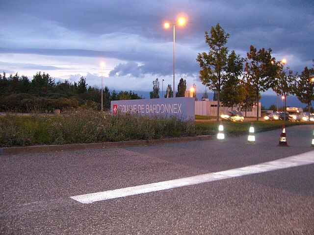
Bardonnex
- municipality in Switzerland
Hiking in Bardonnex
Bardonnex, located in the Haute-Savoie region of France near the Swiss border, offers a variety of outdoor experiences, including numerous hiking trails that cater to different skill levels. The beautiful landscapes, with views of the surrounding mountains and valleys, make it a fantastic destination for hikers....
- Country:
- Local Dialing Code: 022
- Licence Plate Code: GE
- Coordinates: 46° 8' 0" N, 6° 6' 0" E
- GPS tracks (wikiloc): [Link]
- AboveSeaLevel: 470 м m
- Area: 5.0 sq km
- Population: 2215
- Web site: [Link]


Viry
- commune in Haute-Savoie, France
Hiking in Viry
Viry, located in the Haute-Savoie region of France, is a beautiful area that offers a variety of hiking opportunities for both beginners and experienced trekkers. The region is characterized by its stunning alpine scenery, lush forests, and picturesque views of the surrounding mountains, including the iconic Mont Blanc....
- Country:
- Postal Code: 74580
- Coordinates: 46° 7' 3" N, 6° 2' 15" E
- GPS tracks (wikiloc): [Link]
- Area: 26.16 sq km
- Population: 4806

Neydens
- commune in Haute-Savoie, France
Hiking in Neydens
Neydens, located in the Haute-Savoie region of France, is a charming destination that offers beautiful natural landscapes and opportunities for hiking enthusiasts. Situated near the foothills of the Alps, it provides access to a variety of trails that cater to different skill levels....
- Country:
- Postal Code: 74160
- Coordinates: 46° 7' 17" N, 6° 6' 16" E
- GPS tracks (wikiloc): [Link]
- Area: 6.96 sq km
- Population: 1794


Feigères
- commune in Haute-Savoie, France
Hiking in Feigères
Feigères is a charming commune located in the Auvergne-Rhône-Alpes region of France, near the border with Switzerland. It provides a picturesque backdrop for hiking enthusiasts, with its beautiful landscapes, rolling hills, and proximity to the Alps....
- Country:
- Postal Code: 74160
- Coordinates: 46° 6' 46" N, 6° 4' 50" E
- GPS tracks (wikiloc): [Link]
- Area: 7.66 sq km
- Population: 1561