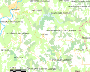
Saint-Julien-le-Pèlerin (Saint-Julien-le-Pèlerin)

- commune in Corrèze, France
- Country:

- Postal Code: 19430
- Coordinates: 45° 1' 3" N, 2° 4' 38" E


- GPS tracks (wikiloc): [Link]
- Area: 15.4 sq km
- Population: 129
- Wikipedia en: wiki(en)
- Wikipedia: wiki(fr)
- Wikidata storage: Wikidata: Q736007
- Wikipedia Commons Category: [Link]
- Freebase ID: [/m/03mf_vt]
- SIREN number: [211921507]
- BnF ID: [152498519]
- INSEE municipality code: 19215
Shares border with regions:


Camps-Saint-Mathurin-Léobazel
- commune in Corrèze, France
- Country:
- Postal Code: 19430
- Coordinates: 44° 58' 58" N, 1° 59' 23" E
- GPS tracks (wikiloc): [Link]
- AboveSeaLevel: 540 м m
- Area: 34.08 sq km
- Population: 244

Sexcles
- commune in Corrèze, France
- Country:
- Postal Code: 19430
- Coordinates: 45° 2' 49" N, 2° 0' 29" E
- GPS tracks (wikiloc): [Link]
- Area: 25.91 sq km
- Population: 234
Siran
- commune in Cantal, France
- Country:
- Postal Code: 15150
- Coordinates: 44° 57' 17" N, 2° 7' 40" E
- GPS tracks (wikiloc): [Link]
- Area: 50.88 sq km
- Population: 489


Lamativie
- former commune in Lot, France
- Country:
- Postal Code: 46190
- Coordinates: 44° 57' 36" N, 2° 2' 26" E
- GPS tracks (wikiloc): [Link]
- Area: 12.82 sq km
- Population: 54

Goulles
- commune in Corrèze, France
- Country:
- Postal Code: 19430
- Coordinates: 45° 2' 33" N, 2° 4' 47" E
- GPS tracks (wikiloc): [Link]
- Area: 33.4 sq km
- Population: 321