Siran (Siran)

- commune in Cantal, France
- Country:

- Postal Code: 15150
- Coordinates: 44° 57' 17" N, 2° 7' 40" E


- GPS tracks (wikiloc): [Link]
- Area: 50.88 sq km
- Population: 489
- Wikipedia en: wiki(en)
- Wikipedia: wiki(fr)
- Wikidata storage: Wikidata: Q627263
- Wikipedia Commons Category: [Link]
- Freebase ID: [/m/03mbglp]
- GeoNames ID: Alt: [6427661]
- SIREN number: [211502281]
- BnF ID: [15248398b]
- INSEE municipality code: 15228
Shares border with regions:


Calviac
- former commune in Lot, France
- Country:
- Postal Code: 46190
- Coordinates: 44° 55' 23" N, 2° 2' 50" E
- GPS tracks (wikiloc): [Link]
- Area: 26.49 sq km
- Population: 139

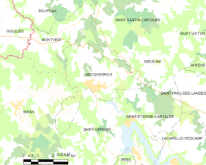
Laroquebrou
- commune in Cantal, France
- Country:
- Postal Code: 15150
- Coordinates: 44° 58' 7" N, 2° 11' 30" E
- GPS tracks (wikiloc): [Link]
- Area: 17.15 sq km
- Population: 887

Saint-Saury
- commune in Cantal, France
- Country:
- Postal Code: 15290
- Coordinates: 44° 52' 5" N, 2° 8' 23" E
- GPS tracks (wikiloc): [Link]
- Area: 30.11 sq km
- Population: 194


Glénat
- commune in Cantal, France
- Country:
- Postal Code: 15150
- Coordinates: 44° 54' 4" N, 2° 10' 51" E
- GPS tracks (wikiloc): [Link]
- Area: 24.27 sq km
- Population: 181

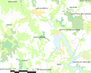
Saint-Gérons
- commune in Cantal, France
- Country:
- Postal Code: 15150
- Coordinates: 44° 57' 2" N, 2° 12' 59" E
- GPS tracks (wikiloc): [Link]
- Area: 16.68 sq km
- Population: 219
Saint-Julien-le-Pèlerin
- commune in Corrèze, France
- Country:
- Postal Code: 19430
- Coordinates: 45° 1' 3" N, 2° 4' 38" E
- GPS tracks (wikiloc): [Link]
- Area: 15.4 sq km
- Population: 129


Lamativie
- former commune in Lot, France
- Country:
- Postal Code: 46190
- Coordinates: 44° 57' 36" N, 2° 2' 26" E
- GPS tracks (wikiloc): [Link]
- Area: 12.82 sq km
- Population: 54


Montvert
- commune in Cantal, France
- Country:
- Postal Code: 15150
- Coordinates: 44° 59' 43" N, 2° 9' 37" E
- GPS tracks (wikiloc): [Link]
- Area: 11.37 sq km
- Population: 119

Goulles
- commune in Corrèze, France
- Country:
- Postal Code: 19430
- Coordinates: 45° 2' 33" N, 2° 4' 47" E
- GPS tracks (wikiloc): [Link]
- Area: 33.4 sq km
- Population: 321