Saint-Médard-la-Rochette (Saint-Médard-la-Rochette)

- commune in Creuse, France
- Country:

- Postal Code: 23200
- Coordinates: 46° 2' 38" N, 2° 8' 46" E


- GPS tracks (wikiloc): [Link]
- AboveSeaLevel: 570 м m
- Area: 38.92 sq km
- Population: 589
- Wikipedia en: wiki(en)
- Wikipedia: wiki(fr)
- Wikidata storage: Wikidata: Q176275
- Wikipedia Commons Category: [Link]
- Freebase ID: [/m/03mfkt1]
- Freebase ID: [/m/03mfkt1]
- GeoNames ID: Alt: [6616136]
- GeoNames ID: Alt: [6616136]
- SIREN number: [212322002]
- SIREN number: [212322002]
- BnF ID: [15251607j]
- BnF ID: [15251607j]
- VIAF ID: Alt: [157550863]
- VIAF ID: Alt: [157550863]
- Library of Congress authority ID: Alt: [nr93009705]
- Library of Congress authority ID: Alt: [nr93009705]
- INSEE municipality code: 23220
- INSEE municipality code: 23220
Shares border with regions:

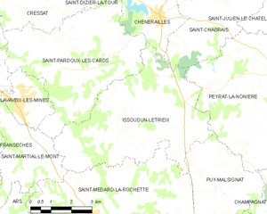
Issoudun-Létrieix
- commune in Creuse, France
- Country:
- Postal Code: 23130
- Coordinates: 46° 3' 37" N, 2° 8' 35" E
- GPS tracks (wikiloc): [Link]
- Area: 26.43 sq km
- Population: 302

Saint-Maixant
- commune in Creuse, France
- Country:
- Postal Code: 23200
- Coordinates: 45° 59' 37" N, 2° 12' 26" E
- GPS tracks (wikiloc): [Link]
- Area: 13.86 sq km
- Population: 234

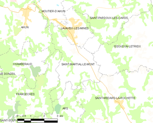
Saint-Martial-le-Mont
- commune in Creuse, France
- Country:
- Postal Code: 23150
- Coordinates: 46° 2' 58" N, 2° 5' 36" E
- GPS tracks (wikiloc): [Link]
- Area: 10.25 sq km
- Population: 244


Ars
- commune in Creuse, France
- Country:
- Postal Code: 23480
- Coordinates: 46° 0' 15" N, 2° 4' 42" E
- GPS tracks (wikiloc): [Link]
- Area: 21.69 sq km
- Population: 257

Alleyrat
- commune in Creuse, France
- Country:
- Postal Code: 23200
- Coordinates: 45° 59' 18" N, 2° 9' 13" E
- GPS tracks (wikiloc): [Link]
- Area: 9.54 sq km
- Population: 146


Blessac
- commune in Creuse, France
- Country:
- Postal Code: 23200
- Coordinates: 45° 57' 31" N, 2° 7' 36" E
- GPS tracks (wikiloc): [Link]
- Area: 17.75 sq km
- Population: 537
- Web site: [Link]


Puy-Malsignat
- commune in Creuse, France
- Country:
- Postal Code: 23130
- Coordinates: 46° 2' 17" N, 2° 13' 7" E
- GPS tracks (wikiloc): [Link]
- Area: 12.61 sq km
- Population: 172