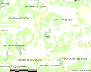
Saint-Maime-de-Péreyrol (Saint-Maime-de-Péreyrol)

- commune in Dordogne, France
- Country:

- Postal Code: 24380
- Coordinates: 45° 0' 53" N, 0° 38' 49" E


- GPS tracks (wikiloc): [Link]
- AboveSeaLevel: 228 м m
- Area: 10.75 sq km
- Population: 282
- Web site: http://www.saint-mayme-de-pereyrol.fr/
- Wikipedia en: wiki(en)
- Wikipedia: wiki(fr)
- Wikidata storage: Wikidata: Q199227
- Wikipedia Commons Category: [Link]
- Freebase ID: [/m/03mg96x]
- Freebase ID: [/m/03mg96x]
- SIREN number: [212404594]
- SIREN number: [212404594]
- BnF ID: [15252102p]
- BnF ID: [15252102p]
- VIAF ID: Alt: [241760276]
- VIAF ID: Alt: [241760276]
- INSEE municipality code: 24459
- INSEE municipality code: 24459
Shares border with regions:

Fouleix
- commune in Dordogne, France
- Country:
- Postal Code: 24380
- Coordinates: 44° 59' 4" N, 0° 40' 49" E
- GPS tracks (wikiloc): [Link]
- Area: 10.94 sq km
- Population: 242
- Web site: [Link]


Vergt
- commune in Dordogne, France
- Country:
- Postal Code: 24380
- Coordinates: 45° 1' 38" N, 0° 43' 6" E
- GPS tracks (wikiloc): [Link]
- Area: 32.52 sq km
- Population: 1650
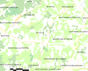
Douville
- commune in Dordogne, France
- Country:
- Postal Code: 24140
- Coordinates: 44° 59' 14" N, 0° 35' 38" E
- GPS tracks (wikiloc): [Link]
- Area: 19.91 sq km
- Population: 452

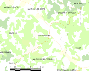
Grun-Bordas
- commune in Dordogne, France
- Country:
- Postal Code: 24380
- Coordinates: 45° 2' 47" N, 0° 39' 8" E
- GPS tracks (wikiloc): [Link]
- AboveSeaLevel: 128 м m
- Area: 12.28 sq km
- Population: 218

Saint-Amand-de-Vergt
- commune in Dordogne, France
- Country:
- Postal Code: 24380
- Coordinates: 44° 59' 14" N, 0° 41' 51" E
- GPS tracks (wikiloc): [Link]
- Area: 12.66 sq km
- Population: 250


Beauregard-et-Bassac
- commune in Dordogne, France
- Country:
- Postal Code: 24140
- Coordinates: 44° 59' 16" N, 0° 38' 31" E
- GPS tracks (wikiloc): [Link]
- Area: 12.02 sq km
- Population: 269