Saint-Manvieu-Norrey (Saint-Manvieu-Norrey)

- commune in Calvados, France
- Country:

- Postal Code: 14740
- Coordinates: 49° 10' 50" N, 0° 30' 5" E


- GPS tracks (wikiloc): [Link]
- AboveSeaLevel: 82 м m
- Area: 8.28 sq km
- Population: 1909
- Web site: http://www.saintmanvieunorrey.fr
- Wikipedia en: wiki(en)
- Wikipedia: wiki(fr)
- Wikidata storage: Wikidata: Q862757
- Wikipedia Commons Category: [Link]
- Freebase ID: [/m/03365t]
- GeoNames ID: Alt: [6615538]
- SIREN number: [211406103]
- BnF ID: [15248019c]
- INSEE municipality code: 14610
Shares border with regions:


Rots
- former commune in Calvados, France
- Country:
- Postal Code: 14980
- Coordinates: 49° 12' 28" N, 0° 28' 40" E
- GPS tracks (wikiloc): [Link]
- Area: 12.22 sq km
- Population: 1439
- Web site: [Link]

Carpiquet
- commune in Calvados, France
- Country:
- Postal Code: 14650
- Coordinates: 49° 11' 10" N, 0° 26' 40" E
- GPS tracks (wikiloc): [Link]
- AboveSeaLevel: 69 м m
- Area: 5.88 sq km
- Population: 2401
- Web site: [Link]


Cheux
- former commune in Calvados, France
- Country:
- Postal Code: 14210
- Coordinates: 49° 9' 58" N, 0° 31' 33" E
- GPS tracks (wikiloc): [Link]
- Area: 14.38 sq km
- Population: 1365
- Web site: [Link]

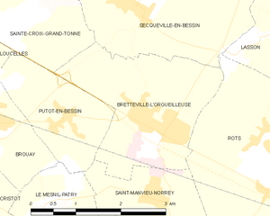
Bretteville-l'Orgueilleuse
- former commune in Calvados, France
- Country:
- Postal Code: 14740
- Coordinates: 49° 12' 41" N, 0° 30' 50" E
- GPS tracks (wikiloc): [Link]
- AboveSeaLevel: 65 м m
- Area: 6.18 sq km
- Population: 2747
- Web site: [Link]


Verson
- commune in Calvados, France
- Country:
- Postal Code: 14790
- Coordinates: 49° 9' 18" N, 0° 27' 9" E
- GPS tracks (wikiloc): [Link]
- Area: 10.36 sq km
- Population: 3498
- Web site: [Link]


Putot-en-Bessin
- former commune in Calvados, France
- Country:
- Postal Code: 14740
- Coordinates: 49° 12' 43" N, 0° 32' 26" E
- GPS tracks (wikiloc): [Link]
- Area: 3.51 sq km
- Population: 418
- Web site: [Link]


Le Mesnil-Patry
- former commune in Calvados, France
- Country:
- Postal Code: 14740
- Coordinates: 49° 11' 43" N, 0° 32' 43" E
- GPS tracks (wikiloc): [Link]
- Area: 3.51 sq km
- Population: 302