Saint-Martin-du-Clocher (Saint-Martin-du-Clocher)

- commune in Charente, France
- Country:

- Postal Code: 16700
- Coordinates: 46° 3' 41" N, 0° 9' 17" E


- GPS tracks (wikiloc): [Link]
- Area: 6.66 sq km
- Population: 124
- Wikipedia en: wiki(en)
- Wikipedia: wiki(fr)
- Wikidata storage: Wikidata: Q749866
- Wikipedia Commons Category: [Link]
- Freebase ID: [/m/03mcdj2]
- GeoNames ID: Alt: [2978305]
- SIREN number: [211603352]
- BnF ID: [15248772r]
- INSEE municipality code: 16335
Shares border with regions:


Les Adjots
- commune in Charente, France
- Country:
- Postal Code: 16700
- Coordinates: 46° 4' 37" N, 0° 12' 23" E
- GPS tracks (wikiloc): [Link]
- AboveSeaLevel: 130 м m
- Area: 10.94 sq km
- Population: 528

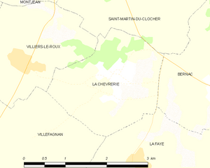
La Chèvrerie
- commune in Charente, France
- Country:
- Postal Code: 16240
- Coordinates: 46° 2' 48" N, 0° 8' 18" E
- GPS tracks (wikiloc): [Link]
- Area: 4.61 sq km
- Population: 132


Montjean
- commune in Charente, France
- Country:
- Postal Code: 16240
- Coordinates: 46° 5' 15" N, 0° 7' 10" E
- GPS tracks (wikiloc): [Link]
- Area: 8.01 sq km
- Population: 237


Villiers-le-Roux
- commune in Charente, France
- Country:
- Postal Code: 16240
- Coordinates: 46° 2' 56" N, 0° 6' 24" E
- GPS tracks (wikiloc): [Link]
- Area: 4.84 sq km
- Population: 138

Londigny
- commune in Charente, France
- Country:
- Postal Code: 16700
- Coordinates: 46° 4' 59" N, 0° 8' 13" E
- GPS tracks (wikiloc): [Link]
- Area: 9.67 sq km
- Population: 249


Bernac
- commune in Charente, France
- Country:
- Postal Code: 16700
- Coordinates: 46° 2' 45" N, 0° 10' 29" E
- GPS tracks (wikiloc): [Link]
- Area: 8.46 sq km
- Population: 493
Montalembert
- commune in Deux-Sèvres, France
- Country:
- Postal Code: 79190
- Coordinates: 46° 6' 38" N, 0° 9' 27" E
- GPS tracks (wikiloc): [Link]
- Area: 11.8 sq km
- Population: 273