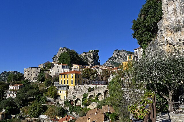
Saint-Martin-du-Var (Saint-Martin-du-Var)

- commune in Alpes-Maritimes, France
 Hiking in Saint-Martin-du-Var
Saint-Martin-du-Var is a charming village located in the Alpes-Maritimes region of France, near Nice. The area is less known than more popular destinations in the French Riviera, making it a great spot for a peaceful hiking experience amidst stunning natural surroundings.
Hiking Trails
-
Chemin des Mésanges: This is a beautiful trail that offers panoramic views of the Var valley and the surrounding mountains. It is relatively easy and suitable for families or beginners, featuring well-marked paths and scenic spots for rest.
-
Le Pont de la Louve: This trail leads you to a picturesque bridge over the Var River. The hike includes an exploration of the ravine and the diverse flora and fauna of the region, making it a great spot for nature lovers.
-
La Colline de Saint-Martin: This shorter hike takes you to the hill overlooking the village. From the top, you’ll have breathtaking views of the Mediterranean as well as the foothills of the Alps.
-
GR51 (Grande Randonnée 51): This long-distance hiking path runs along the Riviera and passes near St-Martin-du-Var. It's ideal for more experienced hikers and offers an extensive exploration of the stunning coastal and inland landscapes.
Preparation Tips
- Weather: Always check the weather before heading out, as conditions can vary greatly, especially in the mountains.
- Clothing: Wear comfortable hiking boots and dress in layers. Consider bringing waterproof gear depending on the season.
- Water and Snacks: Carry enough water and some energy-boosting snacks, especially for longer hikes.
- Maps and Trails: While many trails are marked, having a map or using a hiking app can enhance your experience and help you stay on track.
Local Attractions
After a day of hiking, you might want to explore the village itself, which boasts a lovely church and some charming streets. The area is also known for its local cuisine, so don’t miss the opportunity to try some regional dishes in nearby restaurants.
Overall, hiking in Saint-Martin-du-Var provides a wonderful blend of natural beauty and a quiet escape from the busier tourist spots of the French Riviera. Enjoy your adventure!
- Country:

- Postal Code: 06670
- Coordinates: 43° 49' 20" N, 7° 11' 32" E


- GPS tracks (wikiloc): [Link]
- Area: 5.59 sq km
- Population: 2882
- Web site: http://www.saintmartinduvar.fr/
- Wikipedia en: wiki(en)
- Wikipedia: wiki(fr)
- Wikidata storage: Wikidata: Q865786
- Wikipedia Commons Category: [Link]
- Freebase ID: [/m/03m4z6z]
- Freebase ID: [/m/03m4z6z]
- GeoNames ID: Alt: [6425676]
- GeoNames ID: Alt: [6425676]
- SIREN number: [210601266]
- SIREN number: [210601266]
- VIAF ID: Alt: [126829025]
- VIAF ID: Alt: [126829025]
- Library of Congress authority ID: Alt: [n95085661]
- Library of Congress authority ID: Alt: [n95085661]
- INSEE municipality code: 06126
- INSEE municipality code: 06126
Shares border with regions:


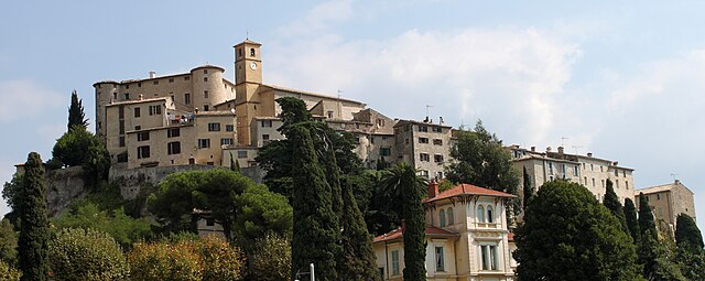
Saint-Blaise
- commune in Alpes-Maritimes, France
Hiking in Saint-Blaise
Saint-Blaise, situated in the Alpes-Maritimes region of France, offers a beautiful backdrop for hiking enthusiasts. Nestled near Nice and the Mediterranean coast, it provides not only stunning views but also a variety of trails suitable for different skill levels....
- Country:
- Postal Code: 06670
- Coordinates: 43° 49' 18" N, 7° 14' 15" E
- GPS tracks (wikiloc): [Link]
- Area: 8.04 sq km
- Population: 1013

Gilette
- commune in Alpes-Maritimes, France
Hiking in Gilette
Gillette, Wyoming, is surrounded by a variety of outdoor recreational opportunities for hiking enthusiasts. The area is characterized by scenic landscapes, rolling hills, and rugged terrain typical of the high plains region. Here are a few hiking options and considerations while exploring the area:...
- Country:
- Postal Code: 06830
- Coordinates: 43° 50' 58" N, 7° 9' 49" E
- GPS tracks (wikiloc): [Link]
- Area: 10.18 sq km
- Population: 1536


La Roquette-sur-Var
- commune in Alpes-Maritimes, France
Hiking in La Roquette-sur-Var
La Roquette-sur-Var is a charming village located in the Alpes-Maritimes department in the Provence-Alpes-Côte d'Azur region of France. It offers access to beautiful natural landscapes, making it a great spot for hiking enthusiasts. Here are some highlights and tips for hiking in and around La Roquette-sur-Var:...
- Country:
- Postal Code: 06670
- Coordinates: 43° 49' 41" N, 7° 11' 56" E
- GPS tracks (wikiloc): [Link]
- Area: 3.99 sq km
- Population: 906

Carros
- commune in Alpes-Maritimes, France
Hiking in Carros
Carros, located in the Alpes-Maritimes region of France near Nice, offers a variety of hiking opportunities that cater to all skill levels. The area is characterized by its stunning natural landscapes, including hills, forests, and panoramic views of the Mediterranean coast....
- Country:
- Postal Code: 06510
- Coordinates: 43° 46' 21" N, 7° 11' 36" E
- GPS tracks (wikiloc): [Link]
- Area: 15.11 sq km
- Population: 12008
- Web site: [Link]


Le Broc
- commune in Alpes-Maritimes, France
Hiking in Le Broc
Le Broc, located in the Alpes-Maritimes region of France, is a charming village that offers a variety of hiking opportunities suitable for different skill levels. The area's natural beauty is characterized by its rocky landscapes, rolling hills, and stunning views of the surrounding mountains and valleys....
- Country:
- Postal Code: 06510
- Coordinates: 43° 48' 34" N, 7° 10' 12" E
- GPS tracks (wikiloc): [Link]
- Area: 18.65 sq km
- Population: 1401
- Web site: [Link]