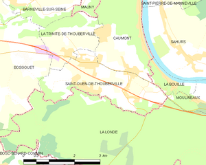
Saint-Ouen-de-Thouberville (Saint-Ouen-de-Thouberville)
- commune in Eure, France
- Country:

- Postal Code: 27310
- Coordinates: 49° 21' 24" N, 0° 53' 16" E


- GPS tracks (wikiloc): [Link]
- Area: 6.32 sq km
- Population: 2357
- Wikipedia en: wiki(en)
- Wikipedia: wiki(fr)
- Wikidata storage: Wikidata: Q775798
- Wikipedia Commons Category: [Link]
- Freebase ID: [/m/02x6cm7]
- GeoNames ID: Alt: [6430617]
- SIREN number: [212705800]
- BnF ID: [15253813h]
- VIAF ID: Alt: [238135562]
- INSEE municipality code: 27580
Shares border with regions:


La Bouille
- commune in Seine-Maritime, France
- Country:

- Postal Code: 76530
- Coordinates: 49° 21' 4" N, 0° 55' 54" E


- GPS tracks (wikiloc): [Link]
- Area: 1.27 sq km
- Population: 750
- Web site: [Link]


Moulineaux
- commune in Seine-Maritime, France
- Country:

- Postal Code: 76530
- Coordinates: 49° 20' 33" N, 0° 57' 57" E


- GPS tracks (wikiloc): [Link]
- Area: 3.47 sq km
- Population: 957
- Web site: [Link]
La Londe
- commune in Seine-Maritime, France
- Country:

- Postal Code: 76500
- Coordinates: 49° 18' 22" N, 0° 57' 11" E


- GPS tracks (wikiloc): [Link]
- Area: 30.98 sq km
- Population: 2310
- Web site: [Link]
