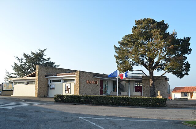
Saint-Père-en-Retz (Saint-Père-en-Retz)

- commune in Loire-Atlantique, France
- Country:

- Postal Code: 44320
- Coordinates: 47° 12' 20" N, 2° 2' 27" E


- GPS tracks (wikiloc): [Link]
- Area: 62.72 sq km
- Population: 4488
- Web site: http://www.saintpereenretz.fr
- Wikipedia en: wiki(en)
- Wikipedia: wiki(fr)
- Wikidata storage: Wikidata: Q1065269
- Wikipedia Commons Category: [Link]
- Freebase ID: [/m/03nwcmg]
- Freebase ID: [/m/03nwcmg]
- GeoNames ID: Alt: [2977614]
- GeoNames ID: Alt: [2977614]
- SIREN number: [214401879]
- SIREN number: [214401879]
- BnF ID: [15260356w]
- BnF ID: [15260356w]
- VIAF ID: Alt: [198572833]
- VIAF ID: Alt: [198572833]
- Library of Congress authority ID: Alt: [no2011170373]
- Library of Congress authority ID: Alt: [no2011170373]
- PACTOLS thesaurus ID: [pcrtAXGRN1iQDR]
- PACTOLS thesaurus ID: [pcrtAXGRN1iQDR]
- INSEE municipality code: 44187
- INSEE municipality code: 44187
Shares border with regions:


Corsept
- commune in Loire-Atlantique, France
- Country:
- Postal Code: 44560
- Coordinates: 47° 16' 39" N, 2° 3' 33" E
- GPS tracks (wikiloc): [Link]
- Area: 23.62 sq km
- Population: 2700
- Web site: [Link]
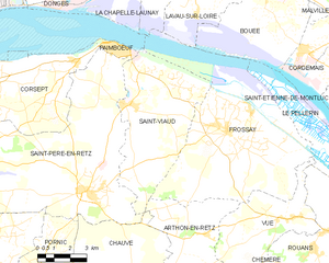
Saint-Viaud
- commune in Loire-Atlantique, France
- Country:
- Postal Code: 44320
- Coordinates: 47° 15' 21" N, 2° 1' 10" E
- GPS tracks (wikiloc): [Link]
- Area: 32.63 sq km
- Population: 2407
- Web site: [Link]


Saint-Michel-Chef-Chef
- commune in Loire-Atlantique, France
- Country:
- Postal Code: 44730
- Coordinates: 47° 10' 51" N, 2° 8' 55" E
- GPS tracks (wikiloc): [Link]
- Area: 25.12 sq km
- Population: 4642
- Web site: [Link]


Paimbœuf
- commune in Loire-Atlantique, France
- Country:
- Postal Code: 44560
- Coordinates: 47° 17' 15" N, 2° 1' 54" E
- GPS tracks (wikiloc): [Link]
- Area: 2 sq km
- Population: 3197
- Web site: [Link]


Chauvé
- commune in Loire-Atlantique, France
- Country:
- Postal Code: 44320
- Coordinates: 47° 9' 4" N, 1° 59' 10" E
- GPS tracks (wikiloc): [Link]
- Area: 40.98 sq km
- Population: 2753
- Web site: [Link]


Pornic
- commune in Loire-Atlantique, France
- Country:
- Postal Code: 44210
- Coordinates: 47° 6' 43" N, 2° 5' 20" E
- GPS tracks (wikiloc): [Link]
- Area: 94.18 sq km
- Population: 14902
- Web site: [Link]

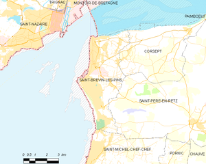
Saint-Brevin-les-Pins
- commune in Loire-Atlantique, France
- Country:
- Postal Code: 44250
- Coordinates: 47° 14' 47" N, 2° 10' 1" E
- GPS tracks (wikiloc): [Link]
- Area: 19.29 sq km
- Population: 13492
- Web site: [Link]