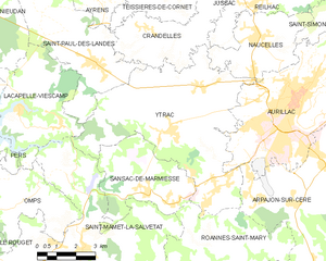
Saint-Paul-des-Landes (Saint-Paul-des-Landes)
- commune in Cantal, France
- Country:

- Postal Code: 15250
- Coordinates: 44° 56' 37" N, 2° 18' 52" E


- GPS tracks (wikiloc): [Link]
- Area: 19 sq km
- Population: 1539
- Web site: http://www.saint-paul-des-landes.fr
- Wikipedia en: wiki(en)
- Wikipedia: wiki(fr)
- Wikidata storage: Wikidata: Q808835
- Wikipedia Commons Category: [Link]
- Freebase ID: [/m/03mbb2y]
- GeoNames ID: Alt: [6427646]
- SIREN number: [211502042]
- BnF ID: [15248374b]
- INSEE municipality code: 15204
Shares border with regions:


Lacapelle-Viescamp
- commune in Cantal, France
- Country:

- Postal Code: 15150
- Coordinates: 44° 55' 22" N, 2° 15' 46" E


- GPS tracks (wikiloc): [Link]
- Area: 15.62 sq km
- Population: 511


Nieudan
- commune in Cantal, France
- Country:

- Postal Code: 15150
- Coordinates: 44° 59' 1" N, 2° 14' 35" E


- GPS tracks (wikiloc): [Link]
- Area: 12.4 sq km
- Population: 111


Ayrens
- commune in Cantal, France
- Country:

- Postal Code: 15250
- Coordinates: 44° 59' 5" N, 2° 19' 37" E


- GPS tracks (wikiloc): [Link]
- Area: 25.5 sq km
- Population: 654
Teissières-de-Cornet
- commune in Cantal, France
- Country:

- Postal Code: 15250
- Coordinates: 44° 58' 13" N, 2° 21' 19" E


- GPS tracks (wikiloc): [Link]
- Area: 9.32 sq km
- Population: 285
Crandelles
- commune in Cantal, France
- Country:

- Postal Code: 15250
- Coordinates: 44° 57' 31" N, 2° 20' 58" E


- GPS tracks (wikiloc): [Link]
- AboveSeaLevel: 620 м m
- Area: 12.46 sq km
- Population: 818


Saint-Étienne-Cantalès
- commune in Cantal, France
- Country:

- Postal Code: 15150
- Coordinates: 44° 56' 51" N, 2° 13' 25" E


- GPS tracks (wikiloc): [Link]
- Area: 11.21 sq km
- Population: 135
- Web site: [Link]


Saint-Victor
- commune in Cantal, France
- Country:

- Postal Code: 15150
- Coordinates: 45° 0' 36" N, 2° 17' 16" E


- GPS tracks (wikiloc): [Link]
- AboveSeaLevel: 600 м m
- Area: 13.53 sq km
- Population: 111


Ytrac
- commune in Cantal, France
- Country:

- Postal Code: 15000
- Coordinates: 44° 54' 43" N, 2° 21' 45" E


- GPS tracks (wikiloc): [Link]
- AboveSeaLevel: 591 м m
- Area: 38.37 sq km
- Population: 4184
- Web site: [Link]
