Saint-Planchers (Saint-Planchers)

- commune in Manche, France
- Country:

- Postal Code: 50400
- Coordinates: 48° 49' 23" N, 1° 31' 33" E


- GPS tracks (wikiloc): [Link]
- Area: 11.96 sq km
- Population: 1351
- Web site: http://www.mairiestplanchers.fr
- Wikipedia en: wiki(en)
- Wikipedia: wiki(fr)
- Wikidata storage: Wikidata: Q1061976
- Wikipedia Commons Category: [Link]
- Freebase ID: [/m/03x_zwd]
- Freebase ID: [/m/03x_zwd]
- GeoNames ID: Alt: [6435638]
- GeoNames ID: Alt: [6435638]
- SIREN number: [215005414]
- SIREN number: [215005414]
- BnF ID: [152625129]
- BnF ID: [152625129]
- INSEE municipality code: 50541
- INSEE municipality code: 50541
Shares border with regions:


Saint-Pair-sur-Mer
- commune in Manche, France
- Country:
- Postal Code: 50380
- Coordinates: 48° 48' 54" N, 1° 34' 7" E
- GPS tracks (wikiloc): [Link]
- Area: 14.42 sq km
- Population: 4025
- Web site: [Link]


Saint-Jean-des-Champs
- commune in Manche, France
- Country:
- Postal Code: 50320
- Coordinates: 48° 49' 39" N, 1° 27' 53" E
- GPS tracks (wikiloc): [Link]
- Area: 19.4 sq km
- Population: 1388


Coudeville-sur-Mer
- commune in Manche, France
- Country:
- Postal Code: 50290
- Coordinates: 48° 52' 52" N, 1° 31' 37" E
- GPS tracks (wikiloc): [Link]
- Area: 8.7 sq km
- Population: 859
- Web site: [Link]


Saint-Aubin-des-Préaux
- commune in Manche, France
- Country:
- Postal Code: 50380
- Coordinates: 48° 48' 15" N, 1° 30' 28" E
- GPS tracks (wikiloc): [Link]
- Area: 8.24 sq km
- Population: 425
- Web site: [Link]


Granville
- commune in Manche, France
- Country:
- Postal Code: 50400
- Coordinates: 48° 50' 17" N, 1° 35' 13" E
- GPS tracks (wikiloc): [Link]
- Area: 9.9 sq km
- Population: 13175
- Web site: [Link]
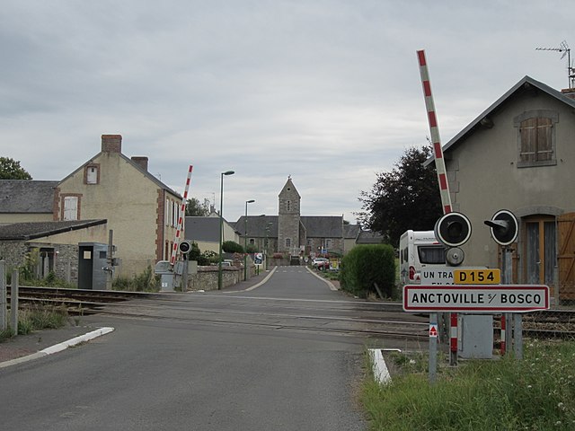
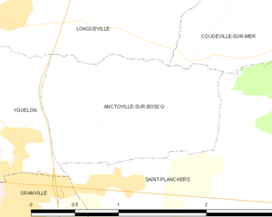
Anctoville-sur-Boscq
- commune in Manche, France
- Country:
- Postal Code: 50400
- Coordinates: 48° 50' 38" N, 1° 31' 56" E
- GPS tracks (wikiloc): [Link]
- AboveSeaLevel: 49 м m
- Area: 2.15 sq km
- Population: 464
- Web site: [Link]

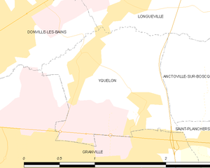
Yquelon
- commune in Manche, France
- Country:
- Postal Code: 50400
- Coordinates: 48° 50' 53" N, 1° 33' 21" E
- GPS tracks (wikiloc): [Link]
- Area: 2.14 sq km
- Population: 1063