Saint-Priest-la-Plaine (Saint-Priest-la-Plaine)

- commune in Creuse, France
- Country:

- Postal Code: 23240
- Coordinates: 46° 11' 28" N, 1° 37' 41" E


- GPS tracks (wikiloc): [Link]
- Area: 21.9 sq km
- Population: 263
- Wikipedia en: wiki(en)
- Wikipedia: wiki(fr)
- Wikidata storage: Wikidata: Q678575
- Wikipedia Commons Category: [Link]
- Freebase ID: [/m/03mfl00]
- Freebase ID: [/m/03mfl00]
- GeoNames ID: Alt: [6429308]
- GeoNames ID: Alt: [6429308]
- SIREN number: [212323604]
- SIREN number: [212323604]
- BnF ID: [15251623s]
- BnF ID: [15251623s]
- PACTOLS thesaurus ID: [pcrtV6b9H8YIND]
- PACTOLS thesaurus ID: [pcrtV6b9H8YIND]
- INSEE municipality code: 23236
- INSEE municipality code: 23236
Shares border with regions:


Noth
- commune in Creuse, France
- Country:
- Postal Code: 23300
- Coordinates: 46° 14' 5" N, 1° 35' 9" E
- GPS tracks (wikiloc): [Link]
- Area: 22.89 sq km
- Population: 515


Naillat
- commune in Creuse, France
- Country:
- Postal Code: 23800
- Coordinates: 46° 15' 52" N, 1° 38' 14" E
- GPS tracks (wikiloc): [Link]
- Area: 36.23 sq km
- Population: 668

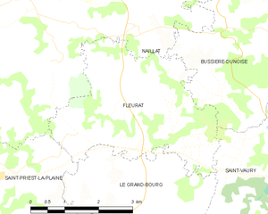
Fleurat
- commune in Creuse, France
- Country:
- Postal Code: 23320
- Coordinates: 46° 14' 26" N, 1° 40' 44" E
- GPS tracks (wikiloc): [Link]
- AboveSeaLevel: 500 м m
- Area: 12.3 sq km
- Population: 297
- Web site: [Link]


Le Grand-Bourg
- commune in Creuse, France
- Country:
- Postal Code: 23240
- Coordinates: 46° 9' 36" N, 1° 38' 40" E
- GPS tracks (wikiloc): [Link]
- Area: 78.91 sq km
- Population: 1219
Lizières
- commune in Creuse, France
- Country:
- Postal Code: 23240
- Coordinates: 46° 12' 39" N, 1° 34' 26" E
- GPS tracks (wikiloc): [Link]
- Area: 14.67 sq km
- Population: 272