Saint-Quentin-sur-Charente (Saint-Quentin-sur-Charente)

- commune in Charente, France
- Country:

- Postal Code: 16150
- Coordinates: 45° 50' 17" N, 0° 40' 13" E


- GPS tracks (wikiloc): [Link]
- Area: 14.39 sq km
- Population: 207
- Wikipedia en: wiki(en)
- Wikipedia: wiki(fr)
- Wikidata storage: Wikidata: Q1436189
- Wikipedia Commons Category: [Link]
- Freebase ID: [/m/03mcdnx]
- GeoNames ID: Alt: [2977264]
- SIREN number: [211603451]
- BnF ID: [152487822]
- INSEE municipality code: 16345
Shares border with regions:


Lésignac-Durand
- commune in Charente, France
- Country:
- Postal Code: 16310
- Coordinates: 45° 48' 42" N, 0° 38' 14" E
- GPS tracks (wikiloc): [Link]
- Area: 19.74 sq km
- Population: 184


Chabanais
- commune in Charente, France
- Country:
- Postal Code: 16150
- Coordinates: 45° 52' 27" N, 0° 43' 11" E
- GPS tracks (wikiloc): [Link]
- Area: 15.01 sq km
- Population: 1692
- Web site: [Link]


Exideuil
- commune in Charente, France
- Country:
- Postal Code: 16150
- Coordinates: 45° 53' 10" N, 0° 40' 25" E
- GPS tracks (wikiloc): [Link]
- Area: 20.56 sq km
- Population: 1037
- Web site: [Link]

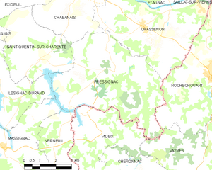
Pressignac
- commune in Charente, France
- Country:
- Postal Code: 16150
- Coordinates: 45° 49' 33" N, 0° 44' 35" E
- GPS tracks (wikiloc): [Link]
- Area: 28.15 sq km
- Population: 379


Suris
- commune in Charente, France
- Country:
- Postal Code: 16270
- Coordinates: 45° 50' 58" N, 0° 38' 14" E
- GPS tracks (wikiloc): [Link]
- Area: 11.08 sq km
- Population: 250