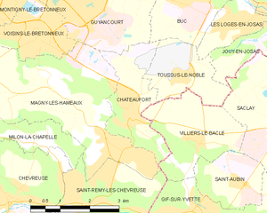
Saint-Rémy-lès-Chevreuse (Saint-Rémy-lès-Chevreuse)
- commune in Yvelines, France
- Country:

- Postal Code: 78470
- Coordinates: 48° 42' 21" N, 2° 4' 19" E


- GPS tracks (wikiloc): [Link]
- Area: 9.65 sq km
- Population: 7738
- Web site: http://www.ville-st-remy-chevreuse.fr
- Wikipedia en: wiki(en)
- Wikipedia: wiki(fr)
- Wikidata storage: Wikidata: Q794124
- Wikipedia Commons Category: [Link]
- Freebase ID: [/m/0c1z8g]
- Freebase ID: [/m/0c1z8g]
- GeoNames ID: Alt: [2977197]
- GeoNames ID: Alt: [2977197]
- SIREN number: [217805753]
- SIREN number: [217805753]
- BnF ID: [15276100c]
- BnF ID: [15276100c]
- VIAF ID: Alt: [126663057]
- VIAF ID: Alt: [126663057]
- archINFORM location ID: [46043]
- archINFORM location ID: [46043]
- Library of Congress authority ID: Alt: [n81108748]
- Library of Congress authority ID: Alt: [n81108748]
- MusicBrainz area ID: [e180baf8-233c-4bc2-ada3-6405217fb739]
- MusicBrainz area ID: [e180baf8-233c-4bc2-ada3-6405217fb739]
- Twitter username: Alt: [StRemyChevreuse]
- Twitter username: Alt: [StRemyChevreuse]
- INSEE municipality code: 78575
- INSEE municipality code: 78575
Shares border with regions:

Gif-sur-Yvette
- commune in Essonne, France
- Country:

- Postal Code: 91190
- Coordinates: 48° 42' 5" N, 2° 8' 1" E


- GPS tracks (wikiloc): [Link]
- Area: 11.6 sq km
- Population: 21069
- Web site: [Link]


Châteaufort
- commune in Yvelines, France
- Country:

- Postal Code: 78117
- Coordinates: 48° 44' 11" N, 2° 5' 28" E


- GPS tracks (wikiloc): [Link]
- Area: 4.88 sq km
- Population: 1366


Gometz-la-Ville
- commune in Essonne, France
- Country:

- Postal Code: 91400
- Coordinates: 48° 40' 18" N, 2° 7' 41" E


- GPS tracks (wikiloc): [Link]
- Area: 9.86 sq km
- Population: 1468
- Web site: [Link]


Chevreuse
- commune in Yvelines, France
- Country:

- Postal Code: 78460
- Coordinates: 48° 42' 27" N, 2° 2' 18" E


- GPS tracks (wikiloc): [Link]
- Area: 13.42 sq km
- Population: 5667
- Web site: [Link]


Boullay-les-Troux
- commune in Essonne, France
- Country:

- Postal Code: 91470
- Coordinates: 48° 40' 43" N, 2° 2' 54" E


- GPS tracks (wikiloc): [Link]
- Area: 4.8 sq km
- Population: 631


Les Molières
- commune in Essonne, France
- Country:

- Postal Code: 91470
- Coordinates: 48° 40' 20" N, 2° 4' 8" E


- GPS tracks (wikiloc): [Link]
- Area: 7.02 sq km
- Population: 2000
- Web site: [Link]


Milon-la-Chapelle
- commune in Yvelines, France
- Country:

- Postal Code: 78470
- Coordinates: 48° 43' 35" N, 2° 2' 57" E


- GPS tracks (wikiloc): [Link]
- Area: 3.06 sq km
- Population: 271


Magny-les-Hameaux
- commune in Yvelines, France
- Country:

- Postal Code: 78114
- Coordinates: 48° 43' 26" N, 2° 5' 3" E


- GPS tracks (wikiloc): [Link]
- Area: 16.64 sq km
- Population: 9197
- Web site: [Link]


Villiers-le-Bâcle
- commune in Essonne, France
- Country:

- Postal Code: 91190
- Coordinates: 48° 43' 32" N, 2° 7' 33" E


- GPS tracks (wikiloc): [Link]
- Area: 6.03 sq km
- Population: 1245
- Web site: [Link]
