Saint-Sulpice-sur-Risle (Saint-Sulpice-sur-Risle)

- commune in Orne, France
- Country:

- Postal Code: 61300
- Coordinates: 48° 46' 50" N, 0° 39' 24" E


- GPS tracks (wikiloc): [Link]
- AboveSeaLevel: 206 м m
- Area: 28.45 sq km
- Population: 1684
- Wikipedia en: wiki(en)
- Wikipedia: wiki(fr)
- Wikidata storage: Wikidata: Q250712
- Wikipedia Commons Category: [Link]
- Freebase ID: [/m/03x_yjb]
- Freebase ID: [/m/03x_yjb]
- GeoNames ID: Alt: [6439303]
- GeoNames ID: Alt: [6439303]
- SIREN number: [216104562]
- SIREN number: [216104562]
- BnF ID: [15268386r]
- BnF ID: [15268386r]
- INSEE municipality code: 61456
- INSEE municipality code: 61456
Shares border with regions:

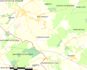
Chéronvilliers
- commune in Eure, France
- Country:
- Postal Code: 27250
- Coordinates: 48° 47' 22" N, 0° 44' 26" E
- GPS tracks (wikiloc): [Link]
- Area: 21.51 sq km
- Population: 520


Chaise-Dieu-du-Theil
- commune in Eure, France
- Country:
- Postal Code: 27580
- Coordinates: 48° 46' 5" N, 0° 45' 40" E
- GPS tracks (wikiloc): [Link]
- Area: 5.93 sq km
- Population: 238
- Web site: [Link]

Chandai
- commune in Orne, France
- Country:
- Postal Code: 61300
- Coordinates: 48° 45' 11" N, 0° 44' 21" E
- GPS tracks (wikiloc): [Link]
- Area: 13.73 sq km
- Population: 651
- Web site: [Link]

Saint-Michel-Tubœuf
- commune in Orne, France
- Country:
- Postal Code: 61300
- Coordinates: 48° 45' 8" N, 0° 41' 20" E
- GPS tracks (wikiloc): [Link]
- AboveSeaLevel: 230 м m
- Area: 8.73 sq km
- Population: 625


Saint-Nicolas-de-Sommaire
- commune in Orne, France
- Country:
- Postal Code: 61550
- Coordinates: 48° 48' 46" N, 0° 36' 32" E
- GPS tracks (wikiloc): [Link]
- Area: 16.28 sq km
- Population: 263


Saint-Martin-d'Écublei
- commune in Orne, France
- Country:
- Postal Code: 61300
- Coordinates: 48° 47' 26" N, 0° 40' 40" E
- GPS tracks (wikiloc): [Link]
- Area: 11.94 sq km
- Population: 641
Saint-Symphorien-des-Bruyères
- commune in Orne, France
- Country:
- Postal Code: 61300
- Coordinates: 48° 47' 18" N, 0° 34' 57" E
- GPS tracks (wikiloc): [Link]
- AboveSeaLevel: 246 м m
- Area: 16.02 sq km
- Population: 518


L'Aigle
- commune in Orne, France
- Country:
- Postal Code: 61300
- Coordinates: 48° 45' 54" N, 0° 37' 39" E
- GPS tracks (wikiloc): [Link]
- AboveSeaLevel: 210 м m
- Area: 18.02 sq km
- Population: 8053
- Web site: [Link]