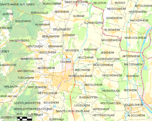
Sainte-Croix-en-Plaine (Sainte-Croix-en-Plaine)

- commune in Haut-Rhin, France
- Country:

- Postal Code: 68127
- Coordinates: 48° 0' 31" N, 7° 23' 5" E


- GPS tracks (wikiloc): [Link]
- Area: 25.77 sq km
- Population: 2902
- Wikipedia en: wiki(en)
- Wikipedia: wiki(fr)
- Wikidata storage: Wikidata: Q83246
- Wikipedia Commons Category: [Link]
- Freebase ID: [/m/03nphcw]
- Freebase ID: [/m/03nphcw]
- GeoNames ID: Alt: [2980648]
- GeoNames ID: Alt: [2980648]
- SIREN number: [216802959]
- SIREN number: [216802959]
- BnF ID: [15271997k]
- BnF ID: [15271997k]
- VIAF ID: Alt: [138820003]
- VIAF ID: Alt: [138820003]
- GND ID: Alt: [4232513-4]
- GND ID: Alt: [4232513-4]
- Library of Congress authority ID: Alt: [nr92012600]
- Library of Congress authority ID: Alt: [nr92012600]
- PACTOLS thesaurus ID: [pcrt8n5wZPFAS1]
- PACTOLS thesaurus ID: [pcrt8n5wZPFAS1]
- INSEE municipality code: 68295
- INSEE municipality code: 68295
Shares border with regions:


Logelheim
- commune in Haut-Rhin, France
- Country:
- Postal Code: 68280
- Coordinates: 48° 1' 17" N, 7° 24' 29" E
- GPS tracks (wikiloc): [Link]
- Area: 4.33 sq km
- Population: 832

Colmar
- commune in Haut-Rhin, France
- Country:
- Postal Code: 68000
- Local Dialing Code: 389
- Coordinates: 48° 4' 52" N, 7° 21' 18" E
- GPS tracks (wikiloc): [Link]
- AboveSeaLevel: 197 м m
- Area: 66.57 sq km
- Population: 70284
- Web site: [Link]


Niederhergheim
- commune in Haut-Rhin, France
- Country:
- Postal Code: 68127
- Coordinates: 47° 59' 5" N, 7° 23' 57" E
- GPS tracks (wikiloc): [Link]
- Area: 12.51 sq km
- Population: 1111


Eguisheim
- commune in Haut-Rhin, France
- Country:
- Postal Code: 68420
- Local Dialing Code: 389
- Coordinates: 48° 2' 35" N, 7° 18' 21" E
- GPS tracks (wikiloc): [Link]
- Area: 14.13 sq km
- Population: 1734
- Web site: [Link]


Dessenheim
- commune in Haut-Rhin, France
- Country:
- Postal Code: 68600
- Coordinates: 47° 58' 32" N, 7° 29' 18" E
- GPS tracks (wikiloc): [Link]
- Area: 19.16 sq km
- Population: 1360

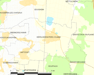
Herrlisheim-près-Colmar
- commune in Haut-Rhin, France
- Country:
- Postal Code: 68420
- Coordinates: 48° 1' 8" N, 7° 19' 34" E
- GPS tracks (wikiloc): [Link]
- Area: 7.68 sq km
- Population: 1794
- Web site: [Link]


Hettenschlag
- commune in Haut-Rhin, France
- Country:
- Postal Code: 68600
- Coordinates: 48° 0' 19" N, 7° 27' 23" E
- GPS tracks (wikiloc): [Link]
- Area: 7.71 sq km
- Population: 337

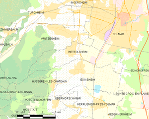
Wettolsheim
- commune in Haut-Rhin, France
- Country:
- Postal Code: 68920
- Coordinates: 48° 3' 25" N, 7° 17' 58" E
- GPS tracks (wikiloc): [Link]
- Area: 8.86 sq km
- Population: 1703


Sundhoffen
- commune in Haut-Rhin, France
- Country:
- Postal Code: 68280
- Coordinates: 48° 2' 36" N, 7° 24' 49" E
- GPS tracks (wikiloc): [Link]
- Area: 12.75 sq km
- Population: 1955