Sainte-Flaive-des-Loups (Sainte-Flaive-des-Loups)

- commune in Vendée, France
- Country:

- Postal Code: 85150
- Coordinates: 46° 36' 47" N, 1° 34' 51" E


- GPS tracks (wikiloc): [Link]
- Area: 36.11 sq km
- Population: 2362
- Web site: http://www.steflaivedesloups.fr/
- Wikipedia en: wiki(en)
- Wikipedia: wiki(fr)
- Wikidata storage: Wikidata: Q818304
- Wikipedia Commons Category: [Link]
- Freebase ID: [/m/03qhkms]
- GeoNames ID: Alt: [2980606]
- SIREN number: [218502110]
- BnF ID: [15278334q]
- INSEE municipality code: 85211
Shares border with regions:


La Chapelle-Achard
- former commune in Vendée, France
- Country:
- Postal Code: 85150
- Coordinates: 46° 35' 22" N, 1° 38' 50" E
- GPS tracks (wikiloc): [Link]
- Area: 21.57 sq km
- Population: 1985


Les Clouzeaux
- former commune in Vendée, France
- Country:
- Postal Code: 85430
- Coordinates: 46° 37' 48" N, 1° 30' 31" E
- GPS tracks (wikiloc): [Link]
- Area: 26.49 sq km
- Population: 2604
- Web site: [Link]


Landeronde
- commune in Vendée, France
- Country:
- Postal Code: 85150
- Coordinates: 46° 39' 29" N, 1° 34' 17" E
- GPS tracks (wikiloc): [Link]
- Area: 17.96 sq km
- Population: 2275
- Web site: [Link]
Le Girouard
- commune in Vendée, France
- Country:
- Postal Code: 85150
- Coordinates: 46° 34' 4" N, 1° 35' 58" E
- GPS tracks (wikiloc): [Link]
- Area: 25.1 sq km
- Population: 1009
- Web site: [Link]


Saint-Georges-de-Pointindoux
- commune in Vendée, France
- Country:
- Postal Code: 85150
- Coordinates: 46° 38' 41" N, 1° 37' 23" E
- GPS tracks (wikiloc): [Link]
- Area: 15.37 sq km
- Population: 1637
- Web site: [Link]

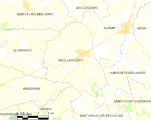
Nieul-le-Dolent
- commune in Vendée, France
- Country:
- Postal Code: 85430
- Coordinates: 46° 34' 30" N, 1° 30' 32" E
- GPS tracks (wikiloc): [Link]
- Area: 27.5 sq km
- Population: 2457
- Web site: [Link]

La Mothe-Achard
- former commune in Vendée, France
- Country:
- Postal Code: 85150
- Coordinates: 46° 37' 7" N, 1° 39' 33" E
- GPS tracks (wikiloc): [Link]
- Area: 8.73 sq km
- Population: 2940
- Web site: [Link]