Sainte-Gemme (Sainte-Gemme)

- commune in Indre, France
- Country:

- Postal Code: 36500
- Coordinates: 46° 51' 8" N, 1° 20' 21" E


- GPS tracks (wikiloc): [Link]
- Area: 32.5 sq km
- Population: 269
- Web site: http://saintegemme.over-blog.com
- Wikipedia en: wiki(en)
- Wikipedia: wiki(fr)
- Wikidata storage: Wikidata: Q1321088
- Wikipedia Commons Category: [Link]
- Freebase ID: [/m/03nw4gd]
- GeoNames ID: Alt: [6613241]
- SIREN number: [213601933]
- BnF ID: [152574977]
- PACTOLS thesaurus ID: [pcrt0ll1X6RFr3]
- INSEE municipality code: 36193
Shares border with regions:

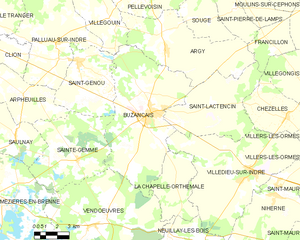
Buzançais
- commune in Indre, France
- Country:
- Postal Code: 36500
- Coordinates: 46° 53' 24" N, 1° 25' 21" E
- GPS tracks (wikiloc): [Link]
- Area: 58.64 sq km
- Population: 4473
- Web site: [Link]
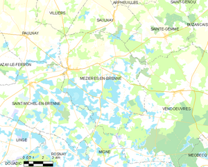
Mézières-en-Brenne
- commune in Indre, France
- Country:
- Postal Code: 36290
- Coordinates: 46° 49' 14" N, 1° 12' 38" E
- GPS tracks (wikiloc): [Link]
- Area: 57.57 sq km
- Population: 1042


Vendœuvres
- commune in Indre, France
- Country:
- Postal Code: 36500
- Coordinates: 46° 48' 6" N, 1° 21' 30" E
- GPS tracks (wikiloc): [Link]
- AboveSeaLevel: 118 м m
- Area: 96.45 sq km
- Population: 1098
Saulnay
- commune in Indre, France
- Country:
- Postal Code: 36290
- Coordinates: 46° 52' 7" N, 1° 16' 7" E
- GPS tracks (wikiloc): [Link]
- Area: 22.2 sq km
- Population: 167
- Web site: [Link]

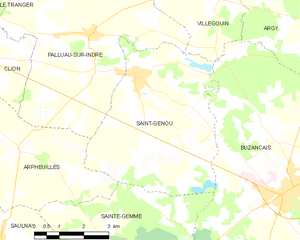
Saint-Genou
- commune in Indre, France
- Country:
- Postal Code: 36500
- Coordinates: 46° 55' 46" N, 1° 20' 17" E
- GPS tracks (wikiloc): [Link]
- Area: 24.41 sq km
- Population: 982
- Web site: [Link]
Arpheuilles
- commune in Indre, France
- Country:
- Postal Code: 36700
- Coordinates: 46° 54' 0" N, 1° 16' 40" E
- GPS tracks (wikiloc): [Link]
- Area: 22.49 sq km
- Population: 224