Sainte-Gemme-Martaillac (Sainte-Gemme-Martaillac)

- commune in Lot-et-Garonne, France
- Country:

- Postal Code: 47250
- Coordinates: 44° 21' 59" N, 0° 9' 8" E


- GPS tracks (wikiloc): [Link]
- Area: 14 sq km
- Population: 420
- Wikipedia en: wiki(en)
- Wikipedia: wiki(fr)
- Wikidata storage: Wikidata: Q222375
- Wikipedia Commons Category: [Link]
- Freebase ID: [/m/03qm2p7]
- GeoNames ID: Alt: [6435059]
- SIREN number: [214702441]
- BnF ID: [15261325v]
- INSEE municipality code: 47244
Shares border with regions:


Grézet-Cavagnan
- commune in Lot-et-Garonne, France
- Country:
- Postal Code: 47250
- Coordinates: 44° 23' 1" N, 0° 7' 55" E
- GPS tracks (wikiloc): [Link]
- Area: 12.55 sq km
- Population: 374


Labastide-Castel-Amouroux
- commune in Lot-et-Garonne, France
- Country:
- Postal Code: 47250
- Coordinates: 44° 20' 23" N, 0° 7' 31" E
- GPS tracks (wikiloc): [Link]
- Area: 11.95 sq km
- Population: 312

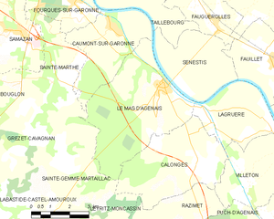
Le Mas-d'Agenais
- commune in Lot-et-Garonne, France
- Country:
- Postal Code: 47430
- Coordinates: 44° 24' 39" N, 0° 13' 2" E
- GPS tracks (wikiloc): [Link]
- Area: 21.18 sq km
- Population: 1489
- Web site: [Link]
Calonges
- commune in Lot-et-Garonne, France
- Country:
- Postal Code: 47430
- Coordinates: 44° 22' 26" N, 0° 14' 27" E
- GPS tracks (wikiloc): [Link]
- Area: 15.99 sq km
- Population: 625
- Web site: [Link]
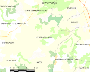
Leyritz-Moncassin
- commune in Lot-et-Garonne, France
- Country:
- Postal Code: 47700
- Coordinates: 44° 19' 38" N, 0° 9' 39" E
- GPS tracks (wikiloc): [Link]
- Area: 20.24 sq km
- Population: 214


Sainte-Marthe
- commune in Lot-et-Garonne, France
- Country:
- Postal Code: 47430
- Coordinates: 44° 24' 51" N, 0° 8' 56" E
- GPS tracks (wikiloc): [Link]
- Area: 9.65 sq km
- Population: 579
- Web site: [Link]