Sainte-Maure-de-Peyriac (Sainte-Maure-de-Peyriac)

- commune in Lot-et-Garonne, France
- Country:

- Postal Code: 47170
- Coordinates: 44° 0' 46" N, 0° 9' 9" E


- GPS tracks (wikiloc): [Link]
- Area: 23.06 sq km
- Population: 345
- Wikipedia en: wiki(en)
- Wikipedia: wiki(fr)
- Wikidata storage: Wikidata: Q1107975
- Wikipedia Commons Category: [Link]
- Freebase ID: [/m/03qm2q8]
- GeoNames ID: Alt: [6435067]
- SIREN number: [214702581]
- BnF ID: [15261339j]
- INSEE municipality code: 47258
Shares border with regions:


Poudenas
- commune in Lot-et-Garonne, France
- Country:
- Postal Code: 47170
- Coordinates: 44° 2' 47" N, 0° 12' 32" E
- GPS tracks (wikiloc): [Link]
- Area: 17.24 sq km
- Population: 253


Saint-Pé-Saint-Simon
- commune in Lot-et-Garonne, France
- Country:
- Postal Code: 47170
- Coordinates: 44° 0' 9" N, 0° 6' 6" E
- GPS tracks (wikiloc): [Link]
- AboveSeaLevel: 120 м m
- Area: 17.46 sq km
- Population: 212


Sos
- commune in Lot-et-Garonne, France
- Country:
- Postal Code: 47170
- Coordinates: 44° 2' 33" N, 0° 8' 25" E
- GPS tracks (wikiloc): [Link]
- Area: 52.89 sq km
- Population: 672
- Web site: [Link]

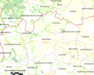
Montréal
- commune in Gers, France
- Country:
- Postal Code: 32250
- Coordinates: 43° 57' 0" N, 0° 12' 8" E
- GPS tracks (wikiloc): [Link]
- Area: 63.05 sq km
- Population: 1173
- Web site: [Link]

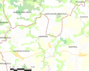
Labarrère
- former commune in Gers, France
- Country:
- Postal Code: 32250
- Coordinates: 43° 57' 35" N, 0° 8' 46" E
- GPS tracks (wikiloc): [Link]
- Area: 12.99 sq km
- Population: 209