
Montréal (Montréal)

- commune in Gers, France
- Country:

- Postal Code: 32250
- Coordinates: 43° 57' 0" N, 0° 12' 8" E


- GPS tracks (wikiloc): [Link]
- Area: 63.05 sq km
- Population: 1173
- Web site: http://www.montrealdugers.fr/
- Wikipedia en: wiki(en)
- Wikipedia: wiki(fr)
- Wikidata storage: Wikidata: Q275905
- Wikipedia Commons Category: [Link]
- Freebase ID: [/m/03gzmjh]
- Freebase ID: [/m/03gzmjh]
- GeoNames ID: Alt: [6432033]
- GeoNames ID: Alt: [6432033]
- SIREN number: [213202906]
- SIREN number: [213202906]
- BnF ID: [15255876w]
- BnF ID: [15255876w]
- MusicBrainz area ID: [7ec3830d-84c8-4232-98bd-9081e6d3a92e]
- MusicBrainz area ID: [7ec3830d-84c8-4232-98bd-9081e6d3a92e]
- INSEE municipality code: 32290
- INSEE municipality code: 32290
Shares border with regions:


Poudenas
- commune in Lot-et-Garonne, France
- Country:
- Postal Code: 47170
- Coordinates: 44° 2' 47" N, 0° 12' 32" E
- GPS tracks (wikiloc): [Link]
- Area: 17.24 sq km
- Population: 253
Sainte-Maure-de-Peyriac
- commune in Lot-et-Garonne, France
- Country:
- Postal Code: 47170
- Coordinates: 44° 0' 46" N, 0° 9' 9" E
- GPS tracks (wikiloc): [Link]
- Area: 23.06 sq km
- Population: 345

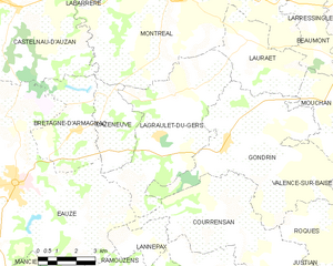
Lagraulet-du-Gers
- commune in Gers, France
- Country:
- Postal Code: 32330
- Coordinates: 43° 54' 12" N, 0° 12' 45" E
- GPS tracks (wikiloc): [Link]
- Area: 27.22 sq km
- Population: 544

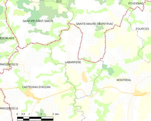
Labarrère
- former commune in Gers, France
- Country:
- Postal Code: 32250
- Coordinates: 43° 57' 35" N, 0° 8' 46" E
- GPS tracks (wikiloc): [Link]
- Area: 12.99 sq km
- Population: 209
Lauraët
- commune in Gers, France
- Country:
- Postal Code: 32330
- Coordinates: 43° 56' 4" N, 0° 14' 57" E
- GPS tracks (wikiloc): [Link]
- Area: 12.71 sq km
- Population: 255


Beaumont
- commune in Gers, France
- Country:
- Postal Code: 32100
- Coordinates: 43° 56' 47" N, 0° 17' 7" E
- GPS tracks (wikiloc): [Link]
- Area: 7.56 sq km
- Population: 140


Fourcès
- commune in Gers, France
- Country:
- Postal Code: 32250
- Coordinates: 43° 59' 35" N, 0° 13' 49" E
- GPS tracks (wikiloc): [Link]
- Area: 23.72 sq km
- Population: 269
- Web site: [Link]


Larroque-sur-l'Osse
- commune in Gers, France
- Country:
- Postal Code: 32100
- Coordinates: 43° 58' 16" N, 0° 16' 28" E
- GPS tracks (wikiloc): [Link]
- AboveSeaLevel: 132 м m
- Area: 15.07 sq km
- Population: 242
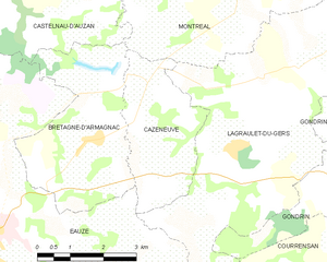
Cazeneuve
- commune in Gers, France
- Country:
- Postal Code: 32800
- Coordinates: 43° 53' 10" N, 0° 9' 42" E
- GPS tracks (wikiloc): [Link]
- Area: 8.31 sq km
- Population: 139
Bretagne-d'Armagnac
- commune in Gers, France
- Country:
- Postal Code: 32800
- Coordinates: 43° 53' 11" N, 0° 8' 17" E
- GPS tracks (wikiloc): [Link]
- Area: 12.35 sq km
- Population: 445